American businessman Randy Rolston has just submitted to the Malaysian and Chinese governments a proposal to conduct an underwater search for MH370 with a clear target for the missing plane.
Flight MH370 disappeared on March 8, 2014 while flying from Kuala Lumpur to Beijing, carrying 239 people, including 154 Chinese citizens. This disappearance has become one of the biggest mysteries in modern aviation history.
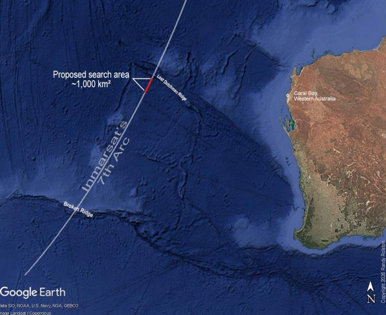
New search area zoning
Mr. Rolston's proposal comes with a 19-page technical report, summarizing various data sources to determine the potential crash site of the Boeing 777.
According to analysis, the area where the collision is likely to occur is within a range of about 1,000km2 under the Indian Ocean, along the "seventh arc" - the last satellite arc recording communication signals from MH370.
The location was determined to be in the range from 23 degrees south latitude to 24 degrees south latitude, about 1,100km off the coast of Coral Bay (West Australia).
This area is much smaller than the more than 230,000km2 of seabed that was surveyed in previous search operations in the southern Indian Ocean.
Mr. Rolston believes that the proposed area has never been searched before, and is located about 1,600km north of the area where the marine robot company Ocean Infinity concluded its most recent search campaign in January 2026.
NASA data reveals unusual traces
One of the notable points in the report is the use of satellite observation data from NASA.
Infrared satellite images recorded increased concentrations of carbon monoxide near the sea surface in the area coinciding with the 7th contact arc at the exact time it was estimated that the plane was emitting the final signal.
According to Mr. Rolston, this carbon monoxide sign may be an important clue but has not been fully considered before, possibly related to the plane's collision with the ocean.
Hypothesis about the final scenario of flight MH370
The report also mentioned several scenarios that could occur in the final stage of the flight, including the possibility of the plane crashing into deep water in Wharton Basin.
Unlike many previous studies that suggested that the plane crashed due to running out of fuel, Mr. Rolston's analysis combined data from Inmarsat satellites, Boeing fuel calculations, infrared images from NASA and drift studies from NOAA and CSIRO.
An example given is data from NOAA floats that passed through the 7th communication arc on March 8, 2014 but were not detected during a 42-day search operation at sea.
This buoy then drifted across the Indian Ocean and drifted ashore on a coral island near Réunion Island in July 2015 - just a week before the first debris of MH370 was found here.
Hope to find a solution after more than a decade
Mr. Rolston believes that with a smaller search scope and new data, the deployment of a targeted underwater survey can yield results.
“After 12 years since MH370 went missing, the families of the victims deserve an answer” - he said. “Finding the plane will help bring clarity and close the pain that has lasted for many years”.


