As soon as it appeared, the first super typhoon of the 2025 typhoon season set a historic record

Khánh Minh |

Erin, the first super typhoon of the 2025 typhoon season, has written its name in meteorological history after going through a rare period of rapid intensification in 24 hours.

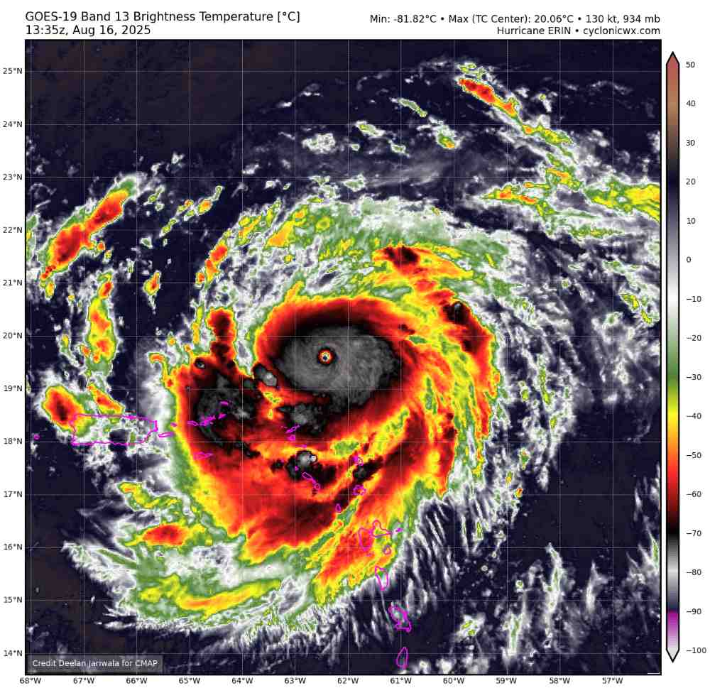
According to the latest storm/low pressure information, in less than 24 hours, storm Erin from Category 1 exploded to Category 5 with winds of nearly 260 km/h, the most rare and dangerous level in the Saffir-Simpson storm scale.

According to the National Hurricane Center (NHC), at 11:00 a.m. on August 15 (local time), Erin was a Category 1 storm with winds of 120 km/h. However, by noon the next day, it had become a Category 5 monster with winds reaching 257 km/h, entering the group of 43 Category 5 storms that were previously recorded in the Atlantic, and the 11th storm since 2016 alone.

It is worth mentioning that this super typhoon is also forecast to continue to strengthen and expand by double or even tripled in size as it moves north. This is a rare rate of increase before September - which is the peak of the storm season.

Experts say rapid intensification - when the storm increases at least 55 km/h in winds within 24 hours - is becoming more and more common as the Earth heats up. Warmer-than-normal Atlantic Ocean waters from climate change and emissions are the fuel that feeds Erin.

We are seeing a clear demonstration of the extreme degrees that warming climate can create, a meteorologist said.

The hurricane hunting crew of the National Oceanic and Atmospheric Administration (NOAA) and the US Air Force's Weathereries squadron No. 53 flew directly into the eye of Hurricane Erin to collect important data on wind speed, pressure and storm structure information that satellites could not grasp. Video: NOAA

Although not forecast to make landfall directly, Erin could still cause dangerous high waves and offshore flows along the Bahamas, the East Coast of the United States and Canada next week.

Puerto Rico, the Virgin Islands and the Leeward Islands are currently experiencing heavy rain, gusts of wind and flash flood warnings. Some places may experience up to 150mm of rain, with the risk of landslides.

Sieu bao Erin tang cap du doi trong vong 24 gio. Anh:
Superstorm Erin intensified violently within 24 hours. Photo: Cyclonicxw.com

The US Coast Guard has closed many seaports in Puerto Rico and the Virgin Islands for prevention.

The East Coast and Bermuda are still in danger if the storm changes direction unexpectedly.

Before Erin, there were four storms in the Atlantic this year, but none have exceeded tropical storm strength. Erin is not only the first strongest storm, but also signals a season with predicted extra activity than average.

This is the fourth consecutive year that a Category 5 storm has occurred in the Atlantic, following terrible names such as Hurricanes Beryl and Milton in 2024. Long-term forecasts from the US Climate Prediction Center show that the waters where Erin formed will continue to be a hurricane-producing hot spring for at least the next few weeks.

Khánh Minh
RELATED NEWS

Forecast of the path and most severely affected area of the tropical depression in the East Sea

|

The low pressure in the East Sea has strengthened into a tropical depression, causing thunderstorms, strong winds and large waves.

Storm Erin is preparing to intensify violently, heading towards the mainland

|

Hurricane Erin officially became the first hurricane of the 2025 Atlantic hurricane season.

Forecast of low pressure in the East Sea affecting Vietnam

|

The latest storm/low pressure news shows that there will be at least 4 low pressure areas in the East Sea and near the East Sea, of which 2 low pressure areas are expected to directly affect Vietnam.

Forecast of major storms, super storms in the acceleration phase

|

The storm season is forecast to explode with 9 storms, major storms, and super storms that may appear from now until the end of November.

Another major lawsuit makes Ms. Paetongtarn's Prime Minister's seat even more shaky

|

Ms. Paetongtarn Shinawatra is simultaneously facing two major legal challenges that made her Thai Prime Minister's seat even more shaky.

EVN reports a loss of more than VND44,000 billion, proposes calculating the loss in average electricity prices

|

According to EVN, if not calculated to recover in electricity prices, it will not promptly compensate for the decreased state investment capital in recent years.

Unexpected reasons Mr. Trump used to promote Ukraine's dealings with Russia

|

The meeting between Mr. Trump and Mr. Putin in Alaska has sparked controversy over a new direction for the Ukrainian conflict.

Schedule of announcing university admission scores: A series of schools announce early

|

Many universities are expected to announce their 2025 benchmarks as early as August 20.

Forecast of the path and most severely affected area of the tropical depression in the East Sea

Khánh Minh |

The low pressure in the East Sea has strengthened into a tropical depression, causing thunderstorms, strong winds and large waves.

Storm Erin is preparing to intensify violently, heading towards the mainland

Thanh Hà |

Hurricane Erin officially became the first hurricane of the 2025 Atlantic hurricane season.

Forecast of low pressure in the East Sea affecting Vietnam

Khánh Minh |

The latest storm/low pressure news shows that there will be at least 4 low pressure areas in the East Sea and near the East Sea, of which 2 low pressure areas are expected to directly affect Vietnam.

Forecast of major storms, super storms in the acceleration phase

Thanh Hà |

The storm season is forecast to explode with 9 storms, major storms, and super storms that may appear from now until the end of November.