Urgent storm news - storm number 4
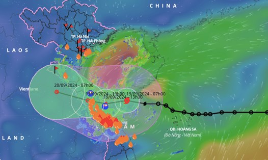
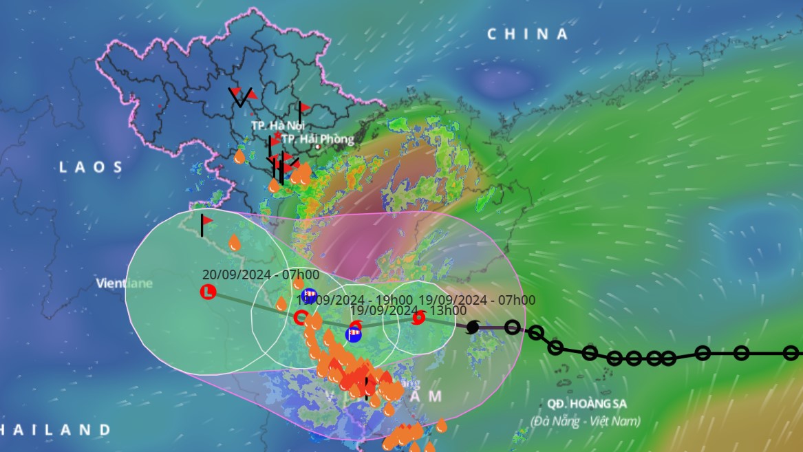
Early on the morning of September 19, the tropical depression (ATND) strengthened into a storm, storm number 4 in 2024. At Con Co (Quang Tri), there were strong winds of level 6, gusting to level 7.
Forecast until 4:00 p.m. on September 19: The center of storm No. 4 is located on the coastal waters from Quang Tri to Quang Nam, with strong winds of level 8, gusting to level 10, moving at a speed of 20-25km/h in a westerly direction.
Level 3 natural disaster risk: Western sea area of the North East Sea (including Hoang Sa archipelago); sea area from Nghe An to Quang Ngai (including Ly Son island, Cu Lao Cham, Con Co, Hon Ngu); mainland area from Ha Tinh to Quang Nam.
At 4:00 a.m. on September 20, the low pressure area was over central Laos; moving 15-20 km/h in the West Northwest direction and gradually weakening. RRTT: level 3: sea area from Nghe An to Quang Nam (including Cu Lao Cham, Con Co, Hon Ngu islands); mainland area from Ha Tinh to Quang Nam.
Strong winds, high waves and thunderstorms forecast at sea
The Department of Dyke Management and Natural Disaster Prevention and Control said that on the day and night of September 19, the West of the North East Sea (including the waters of the Hoang Sa archipelago), the South of the Gulf of Tonkin, the area from Binh Dinh to Ca Mau, the South of the Central East Sea, the South East Sea (including the waters of the Truong Sa archipelago) will have strong winds of level 6-7, gusts of level 8-9, rough seas, and waves from 2.0-5.0m high.
The area from Nghe An to Quang Ngai has strong winds of level 6-7, the area near the storm's eye has level 8, gusts of level 10, waves 2.0-4.0m high, the area near the storm's eye has 3.0-5.0m high; the area from the North of Bac Bo Gulf, Ca Mau to Kien Giang, the Gulf of Thailand and the northern sea area of the Central East Sea has strong winds of level 5-6, gusts of level 7-8, waves 2.0-3.5m high.
Level of disaster risk due to strong winds at sea: level 2, especially in the sea area from Nghe An to Quang Ngai level 3.
Warning of local heavy rain, tornadoes, lightning, strong gusts of wind in the Northern Delta and South Central regions
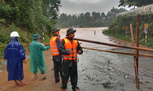
Also according to the Department of Dyke Management and Natural Disaster Prevention and Control, from September 19 to the night of September 20, the area from Ha Tinh to Da Nang will have common rain from 100-300mm, some places over 500mm; Thanh Hoa, Nghe An, Quang Nam, Quang Ngai areas will have common rain from 80-170mm, some places over 300mm.
During the day and night of September 19, the Central Highlands and the South will have widespread rain from 20-40mm, locally over 70mm; the Northern Delta and South Central regions will have widespread rain from 10-30mm, locally over 70mm (rain concentrated in the afternoon and night).
From the night of September 20, heavy rain in the areas gradually decreased. Natural disaster risk level due to heavy rain, tornadoes, lightning: level 1; area from Ha Tinh to Quang Nam: level 2.
Flood warning on rivers from Thanh Hoa to Quang Nam
From September 19 to September 21, there is a possibility of a flood occurring on rivers from Thanh Hoa to Quang Nam, with flood levels rising 3-7m upstream and 2-3m downstream.
During this flood, the peak water level in the upper reaches of Ma River, Buoi River (Thanh Hoa), and upper reaches of Ca River (Nghe An) rose to alert level 1 - 2; Ngan Sau and Ngan Pho Rivers (Ha Tinh) rose to alert level 2 - 3; the lower reaches of Ma River (Thanh Hoa) were still below alert level 1; and the lower reaches of Ca River and La River (Ha Tinh) rose to alert level 1.
Rivers from Quang Binh to Quang Nam will rise to level 1-2, some rivers will rise to level 2; small rivers in Quang Binh and Quang Tri may rise to level 3. Flood risk warning level: level 1.