From dirt routes to modern Avenue
One of the breakthroughs in infrastructure of Ho Chi Minh City is the East - West Avenue project (now Vo Van Kiet - Saigon - Mai Chi Tho river tunnel) 22km long, 42 - 100m wide, started in 2005, completed in 2011, passing through 8 districts.
The most impressive highlight on this route is the Saigon River crossing tunnel (Thu Thiem tunnel) - the first and largest river crossing tunnel in Vietnam and the largest in Southeast Asia with a total length of 1,490m, of which 371m is a underpass applying the most modern and complex construction technology at that time.
With a total capital of more than VND 8,100 billion (from ODA Japan and counterpart capital), the project has formed a continuous East-West traffic axis, reducing inner-city congestion, creating a turning point in urban development for Ho Chi Minh City.
Along with that, Hanoi Highway 15,7km long, from Saigon Bridge to Tan Van intersection, was upgraded under the BOT form with a total capital of about VND4,900 billion, expanded from 6 to 1012 lanes and built parallel roads on both sides. Started in 2010, the route was completed and began to collect tolls to recover capital from April 2021. The expansion of the route helps reduce congestion at the eastern gateway, increasing the connectivity between Ho Chi Minh City and Binh Duong and Dong Nai.
From a dirt road, Pham Van Dong Avenue has become the most modern and beautiful inner-city road in Ho Chi Minh City, connecting Tan Son Nhat airport with important traffic axes such as National Highway 1, National Highway 13 and Ring Road 2.
The route is nearly 14km long, passing through Tan Binh, Go Vap, Binh Thanh districts and Thu Duc city, 30 - 65m wide, including 6 - 12 lanes. The project is invested in the form of BT, with a total capital of about 340 million USD, started in 2008, and opened to traffic on the entire route in 2016. Notable on the route is Binh Loi Bridge - the first Nielsen arch bridge in Vietnam, with a complex technical design, marking a major step forward in the construction of modern bridges and roads.
In the south of the city, Nguyen Huu Tho route, 14km long, is part of the strategic North-South traffic axis of Ho Chi Minh City. Upgraded and put into operation since 2004, the route connects the central area with the urban area of South Saigon, Phu My Hung and especially the industrial park - Hiep Phuoc port.
The two strategic routes - Cong Hoa (3km) and Truong Chinh (4.7km) - have also been upgraded since the early 2000s with a total investment of nearly 730 billion VND. These are the main routes connecting the city center with Tan Son Nhat airport and northwestern districts such as Hoc Mon and Cu Chi.
Iconic bridges and turning points named Metro
In order to solve the problem of separating urban space by the Saigon River, Ho Chi Minh City has invested in a series of modern bridges.
Phu My Bridge is the first modern cable -stayed bridge in Ho Chi Minh City, longer than 2,000m, started in 2005 and completed in 2009 with a total investment of about VND 2,900 billion in the form of BOT. The bridge connecting the banks of the Saigon River, completing the Ring Axis 2, linking the Ho Chi Minh City - Trung Luong - Ho Chi Minh City - Long Thanh - Dau Giay highway, helping to divide and reduce traffic pressure in the central area.
Saigon 2 Bridge inaugurated in 2013, 1,450m long, 6 lanes, total investment of nearly 1,500 billion VND under the BT form to help reduce the load on the old Saigon Bridge and strengthen the connection of Hanoi highway axes.
Thu Thiem Bridge is 1,250m long, completed in 2008 with an investment capital of more than VND 1,100 billion, playing an important role in connecting the existing center with the new urban area of Thu Thiem.
Ba Son Bridge, 1,465m long, completed in 2022 with a total investment of nearly VND3,100 billion under the BT form, not only contributes to urban connectivity and reducing congestion, but is also a unique architectural highlight on the Saigon River.
After 17 years since its approval, Metro Line 1 (Ben Thanh - Suoi Tien) has officially been in operation since December 22, 2024, marking an important step forward in the development of public transport in Ho Chi Minh City. The 19.7km metro line, with 14 stations, connects the city center with Thu Duc City.
Metro No. 1 is expected to help reduce traffic congestion, with an average transportation of about 50,000 passengers/day. After nearly 4 months of operation, metro line No. 1 has contributed to reducing traffic congestion on Hanoi's highways by 80%, while emissions have decreased by 40%, thereby significantly improving the quality of the urban environment.
Modern transportation in the new era
According to Mr. Tran Quang Lam - Director of the Ho Chi Minh City Department of Transport, the city is gradually completing the framework traffic network, especially the belt road system with a total length of nearly 400km.
In particular, Ring 3 is longer than 90km is being accelerated, expected to be basically completed by the end of 2025 and the whole in 2026. 14km left of Ring 2 (64km long) is being urgently deployed to be closed. The Belt 4 project is nearly 207km long - the largest road in the Southeast region - will be submitted to the National Assembly for approval of investment policy in May, aiming to start construction in 2026 and complete in 2028.
National Highways 1, 13, 22, the North - South axis will be expanded to 60m, starting in 2026 and completed in the period of 2027 - 2028.
The Ho Chi Minh City - Moc Bai Expressway, the Ho Chi Minh City - Chon Thanh Expressway connecting road, and the expansion of expressway access routes such as Ho Chi Minh City - Long Thanh - Dau Giay, Ho Chi Minh City - Trung Luong will also be constructed in the coming time, helping the city increase regional connectivity.
Along with the road system, Mr. Tran Quang Lam said that Ho Chi Minh City also develops aviation infrastructure, railways and seaports at the same time.
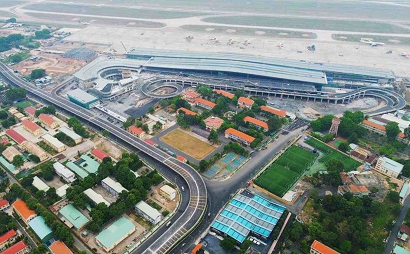
Regarding aviation, Tan Son Nhat airport's T3 terminal (capacity of 20 million passengers/year) will be completed on April 30, 2025, bringing the total capacity of the entire airport to 50 million passengers/year.
Ho Chi Minh City is promoting investment in new railway lines such as Ho Chi Minh City - Can Tho, Thu Thiem - Long Thanh. At the same time, deploy the construction of Can Gio international transit port - a key project to turn Ho Chi Minh City into a logistics center of the region.
Metro - the driving force behind modern urban planning
After Metro Line 1, Ho Chi Minh City has adjusted the planning, increasing from 8 routes with a length of less than 200km to 10 routes with a total length of 510km.
The goal is that by 2035, Ho Chi Minh City will complete 7 routes (355km) and by 2045, the entire network will be completed. The total estimated investment for the entire system is up to 40.2 billion USD.
Metro is not only a means of transportation but will become a "backbone" in planning and renovating modern and civilized urban areas - wherever metro goes, Ho Chi Minh City will develop there. HCMC is converging all the elements of natural times - land - humanity to enter the era of modern, sustainable infrastructure, worthy of becoming a global city - Mr. Tran Quang Lam emphasized.