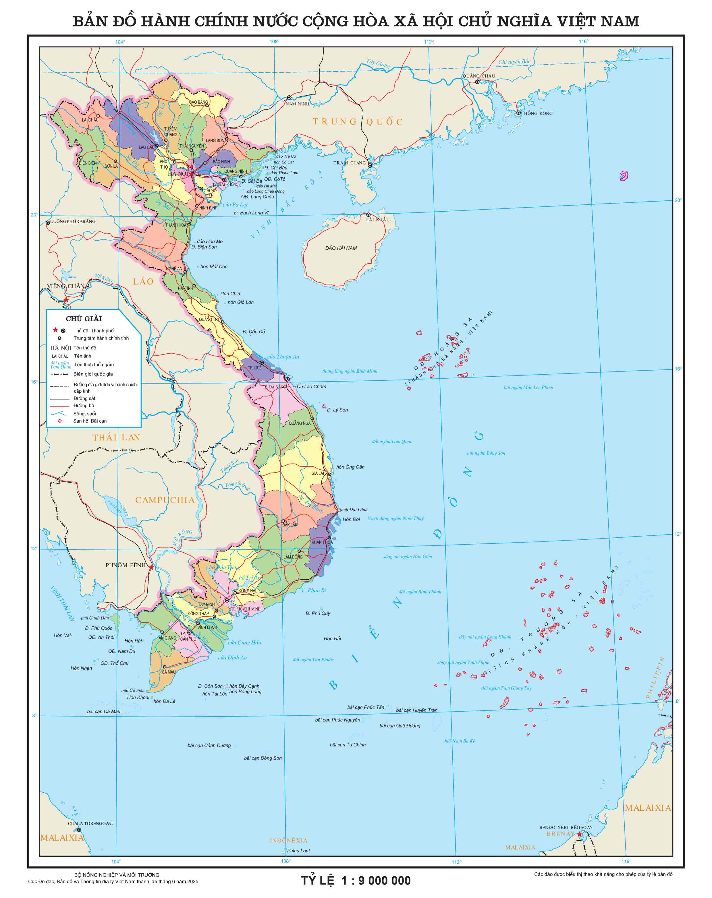
On June 12, with 461/465 delegates participating in the vote (accounting for 96.44% of the total number of National Assembly delegates), the National Assembly voted to pass the Resolution on the arrangement of provincial-level administrative units in 2025. The country has 34 provincial-level administrative units, including 28 provinces and 6 cities. The Resolution takes effect from the date of approval by the National Assembly. On the same day, a detailed administrative map of 34 new provinces and cities, updated accurately, and the largest administrative system after the reorganization was also released.
This map was developed by a team of officers and employees of the Vietnam Department of Measurement, Mapping and Geographical Information (Ministry of Agriculture and Environment). The moment the National Assembly pressed the button to pass, was a historic moment for every cadre and employee here.
Develop more than 750 different options
Speaking to Lao Dong, Mr. Tran Duy Hanh, Director of the Center for Geospatomic Infrastructure (Vietnam Department of Measurement, Mapping and Geographical Information) said that in a very short time, the Department has completed a large volume of all plans for approval. The Department has developed more than 750 maps of different options. The Department's staff have used the most modern geographic information system technology - GIS to build a new map.

Mr. Hanh said that the Department is the place to manage, store and provide unified national geographical data bases nationwide. The Department has completed and put into use the national geographical database with the ratio of 1:25,000, 1:100,000, 1:250,000, 1:500,000, 1:1,000,000. On that national geographical database, technical staff used modern GIS technologies, space analysis, analysis of terrain, transportation, hydrology and population to build maps of the plan according to the instructions and submit to the approval levels to select the most optimal plan.
"In the past period, the Department has concentrated its most elite force, working day and night, at rush hours, every day from 11am to 12pm at night. Initially, the National Assembly was expected to approve on September 1, 2025, then shorten it to August 15, 2025, July 1, 2025, and the National Assembly has just officially approved Resolution No. 202/2025/QH15 on the arrangement of provincial-level administrative units and took effect from June 12, 2025. The collective of cadres, civil servants, public employees and workers of the Department have focused and made efforts to successfully deploy, promptly providing Vietnam's administrative maps of 34 provinces and cities to organizations and individuals for access and exploitation" - Mr. Hanh said.
Providing a wide map of 34 new provinces and cities after the merger
According to Mr. Tran Duy Hanh, the Department is currently ready to provide a 1:9,000,000 Vietnam administrative map to organizations and individuals that can download and use it. Along with that, the Department provided Vietnam administrative maps at a scale of 1:1,000,000 online in the online environment.
This is a new breakthrough, allowing information systems and database management systems to integrate regular and accurate administrative background map services, ensuring full demonstration of national sovereignty and always being updated regularly. People, organizations and businesses can access the Vietnam Geospatprise Portal at https://vnsdi.mae.gov.vn to register and exploit.
Continue to build a standard map system to each commune level
Ms. Ly Thu Hang, Director of the Vietnam Geofortical Portal Management Center (a unit under the Center for Geofortical Infrastructure and Data) said that the National Assembly has just approved a plan to merge provinces, which will soon be at the commune level. The Department has prepared a plan in advance. "We have built according to the draft plans of localities to update the product. When it is official, we will review everything and promptly issue it" - Ms. Hang said.

According to Ms. Hang, for fully merged communes, that is, the whole commune is merged into another commune, it is very simple because the Department has a geographical database system and detailed commune-level boundaries. However, for the partially merged communes, it will be much more difficult because they have to use more documents and the process of determining the subjects takes more time.
The country has 34 new provincial-level administrative units, of which 11 provinces and cities that do not implement the arrangement are the provinces: Cao Bang, Dien Bien, Ha Tinh, Lai Chau, Lang Son, Nghe An, Quang Ninh, Thanh Hoa, Son La and Hanoi City, Hue City.
The 23 new provincial-level administrative units are named: Tuyen Quang, Lao Cai, Thai Nguyen, Phu Tho, Bac Ninh, Hung Yen, Hai Phong, Ninh Binh, Quang Tri, Da Nang, Quang Ngai, Gia Lai, Khanh Hoa, Lam Dong, Dak Lak, Ho Chi Minh City, Dong Nai, Tay Ninh, Can Tho, Vinh Long, Dong Thap, Ca Mau, An Giang.