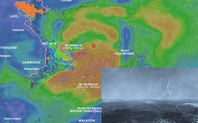
Latest update from the National Center for Hydro-Meteorological Forecasting, at 1:00 p.m. on June 10, the center of the tropical depression was at about 15.3 degrees north latitude; 114.8 degrees east longitude, about 360km east-southeast of Hoang Sa archipelago. The strongest wind near the center of the tropical depression is level 6-7 (39-61km/h), gusting to level 9. The tropical depression is moving slowly in a west-northwest direction at a speed of about 5km/h.
It is forecasted that in the next 24 hours, the tropical depression will move west-northwest, at a speed of about 5 - 10km/h and is likely to strengthen into a storm.
At 1:00 p.m. on June 11, the center of the storm was at about 16.2 degrees north latitude; 113.1 degrees east longitude, in the area east of Hoang Sa archipelago. The strongest intensity near the storm center is level 8, gusting to level 10.
The dangerous area in the East Sea in the next 24 hours will have strong winds of level 6 or higher, from latitude 13 to 19 degrees north; from longitude 111 to 117 degrees east. Level 3 natural disaster risk in the northern East Sea (including Hoang Sa archipelago) and the northern part of the central East Sea.
It is forecasted that in the next 48 hours, the storm will move west-northwest, at a speed of about 10km/h and is likely to strengthen.
At 1:00 p.m. on June 12, the center of the storm was at about 17.3 degrees north latitude; 111.3 degrees east longitude, in the northwest area of Hoang Sa archipelago. The strongest intensity near the storm center is level 9, gusting to level 11.
The dangerous area in the next 24 - 48 hours in the East Sea will have strong winds of level 6 or higher, from latitude 14 to 20 degrees north; from longitude 109.5 to 117 degrees east. Level 3 natural disaster risk: the northern part of the East Sea (including Hoang Sa archipelago), the northern part of the central East Sea and the offshore waters from Quang Tri to Quang Ngai.
In the next 48 to 72 hours, the storm is likely to change direction and move north-northeast at a speed of about 10km/h and continue to strengthen.
Regarding the impact of the tropical depression, the northern East Sea area (including the Hoang Sa archipelago), the northern part of the central East Sea area will have thunderstorms and strong winds of level 6 - 7, then increase to level 8, gusts of level11, waves from 2 - 4m high, rough seas.
In the south of the central East Sea, the southern East Sea (including the Truong Sa archipelago) has strong southwest winds of level 6, sometimes level 7, gusting to level 8 - 9; waves 2 - 4m high, rough seas.
Ship operating in the above sea areas are likely to be affected by thunderstorms, whirlwinds, strong winds and large waves.
By 3:00 p.m. on June 10, the Department of Dyke Management and Natural Disaster Prevention and Control noted that 731 vessels and boats in the central East Sea area, including Hoang Sa island district, need to quickly move out of the affected area and not enter the danger zone.
Ships in other sea areas need to closely monitor the development of the tropical depression to proactively prevent it.