Currently, a very strong storm with the international name Krathon is active in the sea north of Luzon Island (Philippines).
Latest update from the National Center for Hydro-Meteorological Forecasting, at 10:00 a.m. on September 30, the center of storm Krathon was located at about 20.2 degrees north latitude; 121.7 degrees east longitude, in the sea north of Luzon Island (Philippines). The strongest wind near the center of the storm is level 15 (167 - 183 km/h), gusting to level 17.
Moving west northwest, speed about 10km/h.
In the next 24 hours, Typhoon Krathon will move in a west-northwest direction, likely to enter the northeastern waters of the North East Sea. According to current forecasts, the typhoon is unlikely to affect coastal areas and mainland Vietnam.
At 10:00 a.m. on October 1, the center of storm Krathon was at approximately 20.8 degrees north latitude - 119.7 degrees east longitude; in the northeastern sea area of the North East Sea. The strongest wind near the center of the storm was at level 15, gusting to over level 17.
It is forecasted that in the next 48 hours, Typhoon Krathon will move north at a speed of 5 - 10 km/h. At 10:00 on October 2, the center of the storm will be at about 21.9 degrees north latitude - 119.8 degrees east longitude; in the northeastern sea area of the North East Sea.
The strongest wind near the storm center is level 15, gusting over level 17.
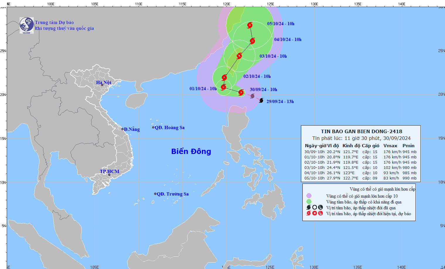
It is forecasted that in the next 72 hours, Typhoon Krathon will move north-northeast at a speed of about 15km/h, gradually weakening in intensity. At 10:00 a.m. on October 3, the center of the storm will be at about 24.4 degrees north latitude - 121.5 degrees east longitude; in the Taiwan area (China).
The strongest wind near the storm center is level 10, gusting to level 12.
From the next 72 to 120 hours, the storm will move mainly in the north-northeast direction, about 5 - 10km per hour, and its intensity will continue to weaken.
Regarding the impact of storm Krathon, the northeastern sea area of the North East Sea has strong winds of level 6 - 7. From early morning on October 1, the wind increased to level 8 - 9, waves 2 - 4m high, then increased to level 10 - 12, the area near the storm center level 13 - 15, gusts above level 17, waves 7 - 9m high; the sea is very rough.
Ships operating in the above mentioned dangerous areas are likely to be affected by storms, whirlwinds, strong winds and large waves.