Warning provinces of the risk of thunderstorms and tornadoes before super typhoon No. 9 Ragasa makes landfall

AN AN |

A representative of the meteorological agency warned that special attention should be paid to thunderstorms and tornadoes when super typhoon No. 9 Ragasa is still 300-400km from the mainland.

According to the National Center for Hydro-Meteorological Forecasting, this afternoon and evening (September 21), the area from Da Nang city to Lam Dong will have scattered showers and thunderstorms, with some places having heavy to very heavy rain.

Rainfall from 1pm to 8pm on September 21 was measured by monitoring stations over 80mm such as: Tra Giap station (Da Nang city) 80.2mm, Dak Ha 1 station (Quang Ngai) 93.4mm, Vinh An station (Gia Lai) 85.9mm, Hoa Thinh station (Dak Lak) 108mm...

According to Mr. Nguyen Van Huong - Head of Weather Forecasting Department, National Center for Hydro-Meteorological Forecasting, the Northern and Central Highlands regions on the night of September 21 are forecast to have scattered showers and thunderstorms with rainfall of 15 - 30mm, locally heavy to very heavy rain over 100mm.

Da Nang city, the South Central Coast and Southern regions in the afternoon and evening of September 22 are forecast to have scattered showers and thunderstorms with rainfall of 10 - 30mm, locally heavy rain over 70mm. Warning of the risk of heavy rain with rainfall greater than 70mm within 3 hours.

During thunderstorms, there is a possibility of tornadoes, lightning, hail and strong gusts of wind. Localized heavy rains are likely to cause flash floods on small rivers and streams, landslides on steep slopes and flooding in low-lying areas.

Ong
Mr. Nguyen Van Huong - Head of Weather Forecast Department, National Center for Hydro-Meteorological Forecasting warned of widespread heavy rain in the North and North Central regions from September 25. Photo: An An

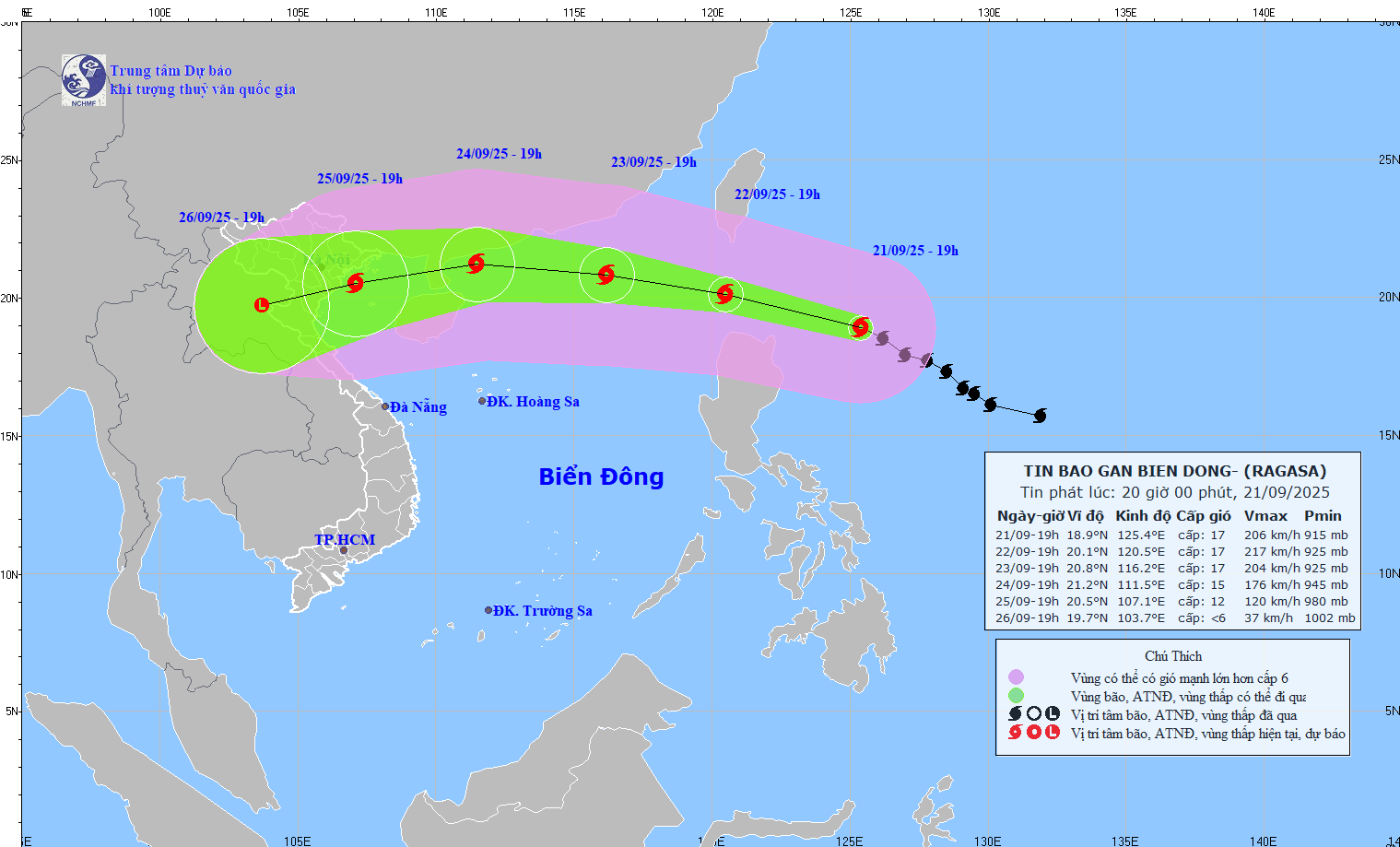
Mr. Huong also said that from September 25 to September 27, super typhoon Ragasa is likely to cause heavy rain and strong winds in the coastal areas of the North as well as the area from Thanh Hoa to Hue.

Mr. Mai Van Khiem - Director of the National Center for Hydro-Meteorological Forecasting - especially warned that before the storm makes landfall, it is necessary to be on guard against thunderstorms and tornadoes when the storm is still 300-400km from the mainland.

"Coastal areas from Quang Ninh to Hue city and Da Nang need to pay attention to thunderstorms due to the impact of the circulation in the front of the storm" - Mr. Khiem analyzed.

Currently, according to the representative of the meteorological agency, the first impact that super typhoon Ragasa needs to pay attention to is the impact of strong winds and large waves at sea on the operation of ships.

Cap nhat vi tri va duong di cua bao Ragasa vao 20 gio ngay 21.9. Nguon: Trung tam Du bao Khi tuong Thuy van Quoc gia
Updated location and path of storm Ragasa at 8:00 p.m. on September 21. Source: National Center for Hydro-Meteorological Forecasting

Due to the influence of the storm circulation in the northern area of the East Sea (including Hoang Sa special area) from tomorrow (September 23), strong winds of level 8-9, then increasing to level 10-14, near the storm's eye will pass level 15-17, gusts above level 17, waves over 10m high; the sea is very rough, possibly sinking all ships, including heavy-duty ships.

The Gulf of Tonkin sea area (including Con Co, Bach Long Vi, Co To special areas) from September 24 has strong storm winds of level 8, near the storm center level 11-13, gusting to level 15-16, very rough seas with thunderstorms, whirlwinds and heavy rain.

"Around early morning of September 25, the coastal waters from Quang Ninh to Ha Tinh will have strong winds of level 7-8, then gradually increase to level 9-10, the storm center will have a frequency of level 12-14, gusts of level 15-16, waves 4-7m high. Ship anchorage areas and aquaculture cages are at great risk of being affected by strong winds and big waves, especially the area from Quang Ninh to Ha Tinh" - Mr. Khiem emphasized.

AN AN
RELATED NEWS

Forecast of the time and focus area of super typhoon No. 9 Ragasa about to make landfall

|

According to the representative of the meteorological agency, it is forecasted that on September 25, super typhoon No. 9 Ragasa will move into the mainland of our country (focusing on the area from Quang Ninh - Ha Tinh).

Forecast of heavy rain in the South and the North

|

According to the meteorological agency, heavy rain in the Southeast will be concentrated in the afternoon and evening of September9; while the North will have thunderstorms from tonight.

Storm Ragasa is about to strengthen into a super typhoon with gusts above level 17 in the next 24 hours, entering the East Sea

|

According to the meteorological agency, in the next 24 hours, storm Ragasa is forecast to strengthen to level 16, gusting above level 17; entering the East Sea in the next 48 hours.

Image welcoming a new generation of American boats to Da Nang

|

Da Nang - The ship that made landfall at USS Tripoli and the cruiser USS Robert Smalls - two symbols of US naval power - arrived at Tien Sa port on the evening of December 8.

Quang Ninh plans to build 9 bridges connecting islands in Van Don

|

Quang Ninh - To facilitate traffic connection between islands in Van Don Special Zone, Quang Ninh province plans to build 9 bridges and 22km of road.

Japan F-35 explores damage from 7.6 Richter earthquake

|

Japan mobilized a series of aircraft, including the F-35, to explore information about the situation and damage after the 7.6 Richter earthquake on the evening of December 8.

Russia controls many key highways on the battlefield

|

On December 9, the Russian military took control of all major highways in the Kupyansk urban cluster, Ukraine.

How reservoirs in Khanh Hoa calculate floodwater and operate overflow discharge

|

Khanh Hoa - Reservoirs will calculate the amount of water in the reservoir according to meteorological bulletins and there will be a notice at least 6 hours before releasing floodwaters.

Forecast of the time and focus area of super typhoon No. 9 Ragasa about to make landfall

AN AN |

According to the representative of the meteorological agency, it is forecasted that on September 25, super typhoon No. 9 Ragasa will move into the mainland of our country (focusing on the area from Quang Ninh - Ha Tinh).

Forecast of heavy rain in the South and the North

LINH ANH |

According to the meteorological agency, heavy rain in the Southeast will be concentrated in the afternoon and evening of September9; while the North will have thunderstorms from tonight.

Storm Ragasa is about to strengthen into a super typhoon with gusts above level 17 in the next 24 hours, entering the East Sea

AN AN |

According to the meteorological agency, in the next 24 hours, storm Ragasa is forecast to strengthen to level 16, gusting above level 17; entering the East Sea in the next 48 hours.