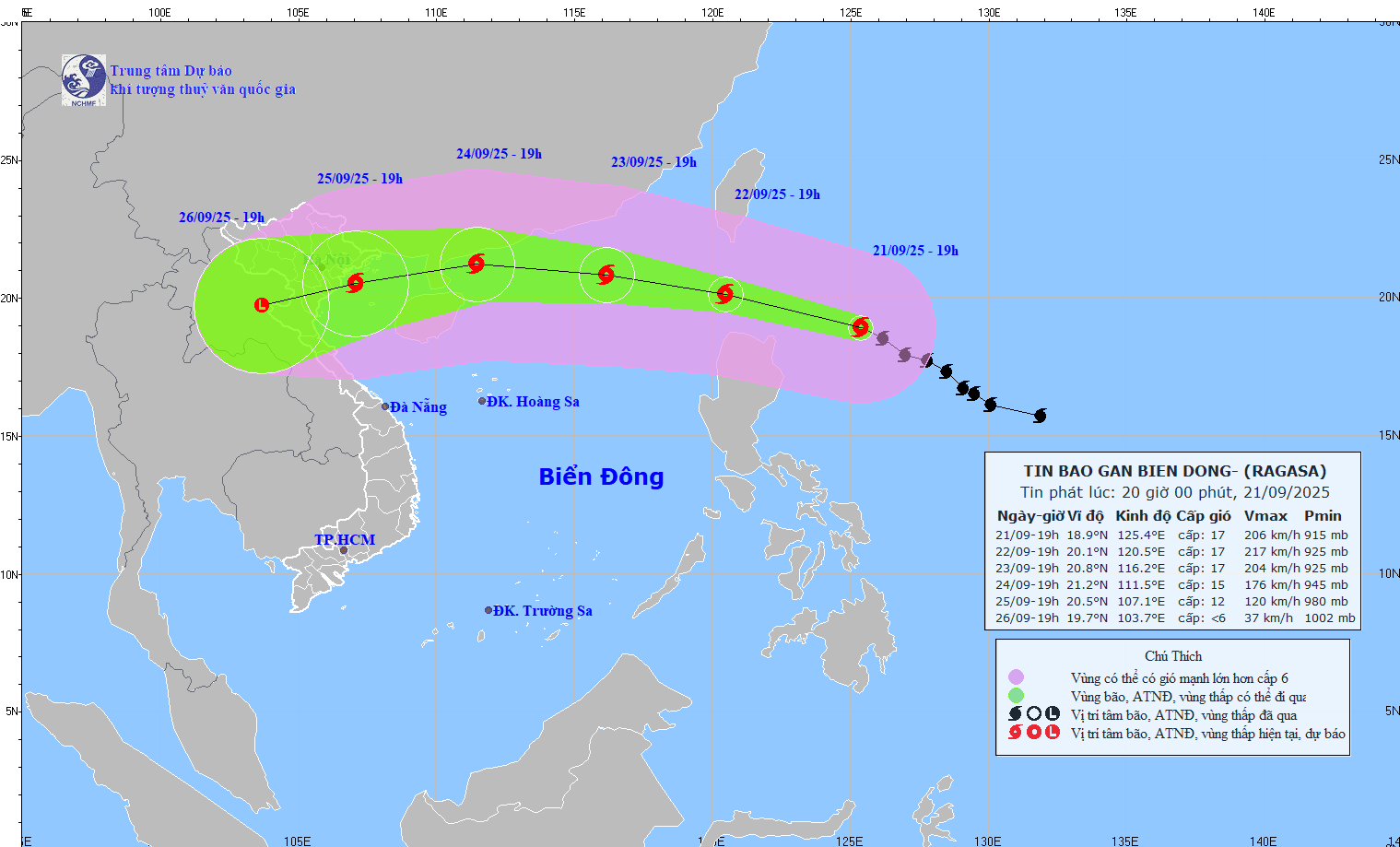
According to the National Center for Hydro-Meteorological Forecasting, at 7:00 p.m. on September 21, the center of super typhoon Ragasa was at about 18.9 degrees north latitude; 125.4 degrees east longitude, about 350km east of Luzon Island (Philippines). The strongest wind near the storm center is level 16 - 17 (184 - 221km/h), gusting over level 17. The super typhoon is moving northwest at a speed of about 15 - 20km/h.

Tonight, Typhoon Ragasa has strengthened into a super typhoon
It is forecasted that in the next 24 hours, the super typhoon will move west-northwest, at a speed of about 20km/h and continue to strengthen. At 7:00 p.m. on September 22, the center of the storm was at about 20.1 degrees north latitude; 120.5 degrees east longitude, about 120km northwest of Luzon Island. Strong intensity level 17, gust above level 17.
The danger zone is 18 degrees north latitude north of the latitude, 117.5 degrees east of the longitude east of the latitude. Level 4 natural disaster risk for the northeastern sea area of the northern East Sea.

Mr. Mai Van Khiem - Director of the National Center for Hydro-Meteorological Forecasting - said that it is forecasted that around the evening of September 22, super typhoon Ragasa will move into the East Sea and become the 9th storm in the East Sea. After that, the storm moved quickly, about 20km/h, with the maximum storm intensity of level 16-17, gusting above level 17 on September 22-23 while still in the East Sea.
"This is the same intensity as the strongest intensity of storm No. 3 Yagi in 2024" - Mr. Khiem commented.
It is forecasted that in the next 48 hours, the super typhoon will continue to move west-northwest, at a speed of about 20km/h. At 7:00 p.m. on September 23, the center of the storm was at about 20.8 degrees north latitude; 116.2 degrees east longitude, in the northern sea area of the northern East Sea. Strong intensity level 16-17, gust above level 17.
The danger zone is 18.5 degrees north latitude north of the latitude, and 114 degrees east longitude east of the latitude. Level 4 natural disaster risk for the northern sea area of the northern East Sea.
It is forecasted that in the next 72 hours, the super typhoon will move west-northwest, at a speed of 15 - 20km/h and gradually weaken. At 7:00 p.m. on September 24, the center of the storm was at about 21.2 degrees north latitude; 111.5 degrees east longitude, in the waters of Guangdong province (China). Strong intensity level 14-15, gust above level 17.
The danger zone is 18.5 degrees north latitude north of the latitude, and 109 degrees east of the longitude east of the latitude east of the latitude. Level 4 natural disaster risk for the northern East Sea area.
It is forecasted that in the next 72 to 120 hours, the super typhoon will move west-southwest, traveling about 20km per hour and the intensity will continue to weaken.
Vietnam mainland landfall on September 25
According to the Director of the Meteorological Agency, in the past 2-3 days, most models and storm forecasting centers of the international and Vietnam have simulated that this is a storm with a very large circulation, very strong intensity when operating in the East Sea, reaching super typhoon level, strongest in the period of September 22 - 23.
In particular, the maximum intensity of storm No. 9 is forecast by the Japan Meteorological Agency to be up to 195 km/h (level 16), gusting over 17. The China Meteorological Administration forecasts that it may reach 223 km/h (above level 17), gusting over 17, the Hong Kong Meteorological Administration (China) forecasts 240 km/h (above level 17), gusting over level 17.
Mr. Khiem said that the most likely scenario is on September 24, when moving to the southern sea area of Guangdong province (China), due to the northern circulation of the storm being affected by terrain friction, storm No. 9 is forecast to decrease in intensity.
When entering the Gulf of Tonkin, the storm intensity will decrease to 2-4 degrees compared to when still offshore.
"It is forecasted that on September 25, the storm will move inland in our country (focusing on the area from Quang Ninh - Ha Tinh)" - Mr. Khiem provided forecast information.
Regarding the impact of the storm at sea, from September 22, the sea area east of the northern East Sea will gradually increase to level 8-9, then increase to level 10-14, the area near the center of the super typhoon will have level 15-17, gusting above level 17. Waves are over 10m high, the sea is rough. Ship operating in the above-mentioned dangerous areas are likely to be affected by thunderstorms, whirlwinds, very strong winds and very large waves.


