Latest update from the National Center for Hydro-Meteorological Forecasting, at 7:00 p.m. on September 27, the center of storm No. 10 Bualoi was at about 15.6 degrees north latitude; 112.3 degrees east longitude, in the area south of Hoang Sa Special Zone, about 460 km east of Da Nang City. The strongest wind near the storm center is level 12 (118-133 km/h), gusting to level 15. The storm is moving west-northwest at a speed of 30-35 km/h.
The most dangerous time is around the night of September 28 - early morning of September 29
It is forecasted that in the next 12 hours, the storm will move west-northwest, at a speed of about 30 km/h and is likely to strengthen.
At 7:00 a.m. on September 28, the center of the storm was at about 16.9 degrees north latitude; 109.3 degrees east longitude, in the waters of Quang Tri - Hue city, about 200 km east of Quang Tri. Strong wind level 12-13, gust level 16.
The danger zone is latitude 13 degrees north - 19.5 degrees north, west of longitude 115 degrees east. Level 3 natural disaster risk for the northern and central East Sea (including Hoang Sa special zone), the sea area from Ha Tinh to Quang Ngai.
It is forecasted that in the next 24 hours, the storm will move west-northwest, at a speed of about 30 km/h. At 7:00 p.m. on September 28, the center of the storm was at about 18.1 degrees north latitude; 106.9 degrees east longitude, in the coastal waters of Nghe An - Quang Tri. Strong wind level 12-13, gust level 16.
The danger zone is latitude 15 degrees north - 20 degrees north, west of longitude 114.5 degrees east. The natural disaster risk level is level 4 for the coastal mainland area from Nghe An to the north of Quang Tri; level 3 for the western sea area of the northern and central East Sea (including Hoang Sa special zone), the sea area from Ha Tinh to Quang Ngai.
It is forecasted that around the night of September 28 - early morning of September 29, the storm is likely to enter the area between Ha Tinh and Quang Tri and this is also the period of strongest rain and wind.
It is forecasted that in the next 48 hours, the storm will move west-northwest at a speed of 20-25 km/h, moving deep inland and weakening into a tropical depression, then into a low pressure area.
At 7:00 p.m. on September 29, the center was at about 20.1 degrees north latitude; 102.3 degrees east longitude, in the Upper Laos area, with winds below level 6. The danger zone is north of latitude 16 degrees north, west of longitude 106.5 degrees east. Level 3 natural disaster risk for Thanh Hoa to Quang Tri (including Hon Ngu island) and the northern Gulf of Tonkin (including Bach Long Vy, Van Don, Co To, Cat Hai and Hon Dau island), mainland area from Ninh Binh to Quang Tri.
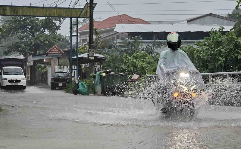
Heavy rain lasts until September 30
At sea, the sea area west of the northern and central East Sea (including Hoang Sa special zone) will have strong winds of level 8-9, near the center of the storm will have winds of level 10-13, gusts of level 16, waves 6-8 m high, near the center of the storm 8-10 m, the sea will be very rough.
The sea area from Thanh Hoa to Quang Ngai (including Hon Ngu island, Con Co and Ly Son special areas) will gradually increase to level 6-7, gusting to level 8-9, waves 3.0-5.0 m high, rough seas; from early morning of September 28, it will increase to level 8-9, near the storm's eye level 10-13, gusting to level 16, waves 5-7 m high, rough seas, extremely destructive forces, extremely strong waves capable of sinking large-load ships. From early morning on September 28, the northern area of the Gulf of Tonkin (including Bach Long Vy, Van Don, Co To, Cat Hai and Hon Dau island) will gradually increase to level 6-7, then increase to level 8-9, gust to level 11, waves 3-5 m high, very rough seas, very dangerous for ships and boats.
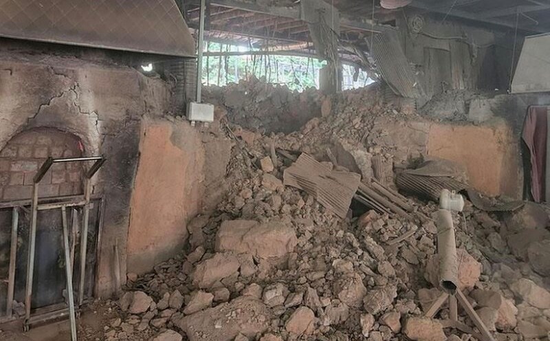
The storm surge in coastal areas and islands from Ninh Binh to Ha Tinh is 0.5-1.5 m high, while the southern Thanh Hoa to northern Ha Tinh is 1-1.1,5 m high. The risk of flooding dykes, coastal roads, riverside is due to rising sea water and big waves in the storm very high in the evening and night of September 28. The weather at sea and coastal areas during the storm is extremely dangerous and unsafe for any means of transport or works in operation. Risk of capsizing, destroying ships, cages, aquaculture areas, dykes, embankments, coastal roads due to strong winds, big waves and rising sea levels.
On land, from the afternoon of September 28, the wind from Thanh Hoa to north of Quang Tri will gradually increase to level 6-7, then increase to level 8-9, the area near the storm's eye will have level 10-12, gusting to level 14, which can cause very heavy damage; coastal areas from Quang Ninh to Ninh Binh, from southern Quang Tri to Hue city will gradually increase to level 6-7, gusting to level 8-9.
Heavy rain from the evening of September 27 to September 30 occurred in the North and the area from Thanh Hoa to Quang Ngai with a total common amount of 100-300 mm, locally over 450 mm; in the Northern Delta, southern Phu Tho and from Thanh Hoa to northern Quang Tri, it was common 200-400 mm, locally over 600 mm. Warning of the risk of heavy rain over 200 mm/3 hours.