
The latest storm and low pressure news on the afternoon of July 22nd from the Philippine Atmospheric, Geophysical and Astronomical Services Administration (PAGASA) said that low pressure 07d near the Philippines is in the PAR forecast area of this country and is highly likely to strengthen into a storm or tropical depression in the next 24 hours.
Currently, the low pressure is 950km southeast of Luzon, Philippines. Previously, at 8 am on July 22, this low pressure was 1,015km from Luzon. At 3 am on the same day, the low pressure was 1,200km from Luzon.
The low pressure when approaching the mainland of the Philippines is expected to cause heavy rain and strong gusts to Northern Luzon. It is forecasted that this system may make landfall in Cagayan, Philippines in the period from July 24 to July 25. In terms of intensity, PAGASA forecasts that this low pressure will strengthen into a tropical storm, with the strongest wind warning being level 2.
According to PAGASA's updated forecast on July 22, Philippine typhoon forecasters have raised their forecast for the possibility of strengthening into a typhoon of the low pressure near the Philippines from low to medium in previous forecasts to medium to high.
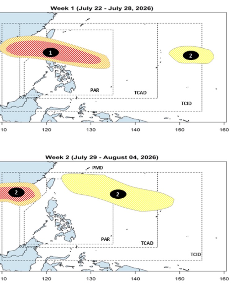
The latest forecast shows that in the period from July 22 to July 28, this low pressure area is likely to strengthen into a storm at an average to high level. Regarding the path, this system will make landfall in the Northern Luzon area - the Northern Luzon Pole, Philippines and then enter the East Sea. Next week from July 29 to August 4, this low pressure area is likely to go deep into the North of the East Sea, possibly heading towards Hainan Island (China) and Vietnam.
Also according to the updated forecast on July 22, in addition to the low pressure area that is likely to strengthen into a storm, entering the East Sea, another low pressure area will also form near the Philippines, in PAGASA's PMD forecast area, and then expand its sphere of influence throughout the forecast period. It is expected that this system will move northwest, towards northern Taiwan (China) with little chance of strengthening into a storm or tropical depression.
According to data from the Joint Typhoon Warning Center (JTWC) on the afternoon of July 22, the low pressure on the Philippine Sea 07d, called 92W by JTWC, is having maximum sustained winds of about 20-30 km/h. Analysis shows that 92W is in a favorable environment for development, with low gusts, good divergence at high altitudes and warm sea surface temperatures (29-30 degrees C).
However, JTWC storm forecasters believe that this low pressure is likely to moderately strengthen into a storm in the next 24 hours. Forecast models suggest that 92W will continue to move northwest in the next 1 to 2 days in the process of strengthening.


