
The latest typhoon and low pressure news on the morning of July 21st from the Philippine Atmospheric, Geophysical and Astronomical Services Administration (PAGASA) said that low pressure 07d is being monitored outside the Philippine Area of Responsibility (PAR). This low pressure is about 1,655km southeast of Luzon, Philippines. Philippine weather forecasters currently predict that 07d is likely to strengthen into a tropical depression in the next 24 hours.
Previously, the time of formation of low pressure 07d was confirmed at 8 pm on July 20, PAGASA said that the low pressure is about 1,740km away from Luzon with an average possibility of strengthening into a tropical depression in the next 24 hours.
If it strengthens into a storm in PAR, the Philippines will name the locality for the storm Kiyapo. This potential storm is also forecast to strengthen the southwest monsoon, causing significant rain in the Philippines from this weekend to next week.
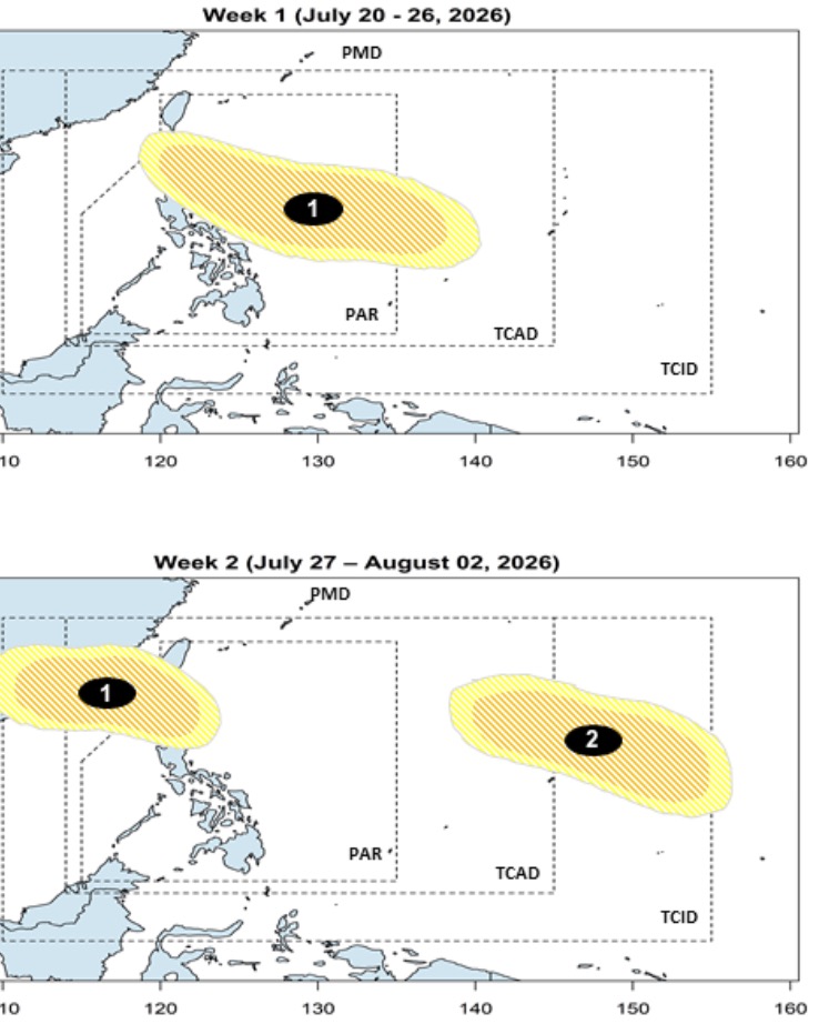
The appearance of this low pressure is consistent with PAGASA's long-term forecast announced on July 20, which stated that in the week from July 20-26, a low pressure will form at the eastern boundary of PAGASA's TCAD forecast area, then gradually move northwest, towards northern Luzon, with the possibility of strengthening into a storm or tropical depression at a low to moderate level.
However, this low pressure will continue to exist until the period from July 27 to August 2, with the possibility of passing through the Ba Sy - Balintang Strait and entering the East Sea. During its operation in the East Sea, PAGASA forecasts that this system is likely to strengthen into a storm or a tropical depression at a low to medium level.
Also in the forecast period from July 27 to August 2, PAGASA assessed that the 2nd low pressure area is likely to develop on the western border of PAGASA's TCID and TCAD forecast areas, with the possibility of strengthening into a storm or a tropical depression at a low to medium level.
Depression near the Philippines 07d is also being monitored by the Japan Meteorological Agency (JMA), which assesses that this system may become a tropical storm in the next few days, with the general direction of movement towards northern Luzon.
The latest forecast models show that this developing weather system is likely to make landfall in the north-central Luzon region on the night of July 24 or early morning of July 25. In terms of intensity, most forecast models also indicate that this low pressure will reach the intensity of a tropical storm to a strong tropical storm.
This low pressure in the Philippine Sea is also being monitored by the Joint Typhoon Warning Center (JTWC) of the US Navy, named 92W. However, JTWC storm forecasters believe that this low pressure is unlikely to strengthen into a storm in the next 24 hours. Currently, 92W has maximum sustained winds of about 30 km/h.


