The latest storm and low pressure information on the afternoon of August 5 from the Philippine Atmospheric, Geophysical and Astronomical Services Administration (PAGASA) said that at 2:00 p.m., low pressure LPA 08a was being monitored inside the Philippine Forecast Area (PAR). This low pressure will enter the Philippine forecast area from the night of August 4.
LPA 08a is located 575km east of Virac, Catanduanes, Philippines.
Philippine typhoon forecasters say LPA 08a is unlikely to intensify into a tropical depression or tropical storm within the next 24 hours.
"The possibility of developing into a tropical storm in the next 24 hours is very low. However, we expect this low pressure to cause rain, especially across Luzon, the Bicol Region and Eastern Visayas," said PAGASA weather forecaster Chenel Dominguez.
The bulletin of the US Navy's Joint Typhoon Warning Center (JTWC) calls this low pressure near the East Sea Invest 96W. The low pressure in the Philippine Sea is also forecast by the JTWC to have little chance of strengthening in the next 24 hours. Currently, Invest 96W has a maximum sustained wind speed of about 30 km/h.
The Philippines is currently in the monsoon season. Scattered showers or thunderstorms are forecast due to the southwest monsoon in the islands of Batanes and Babuyan. The rest of the country will also see scattered showers due to local thunderstorms.
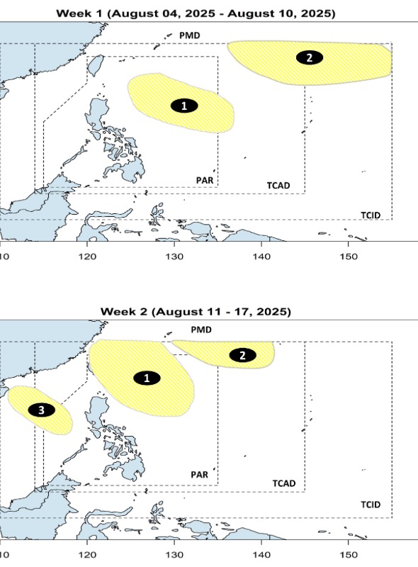
According to PAGASA's forecast on August 4, it is expected that from now until August 17, there will be 3 consecutive low pressure areas appearing around the East Sea.
The two low pressure areas near the East Sea are forecast to form during the week of August 4 to 10 and continue to affect the week of August 11-17.
These two depressions appear at the eastern boundary of PAR and the northeastern boundary of PAGASA's PMD forecast area.
The first low pressure is likely to approach the northeast of Luzon, Philippines while the second low pressure is forecast to only miss the northeast tip of PAR. Both low pressure areas are unlikely to strengthen.
Meanwhile, the low pressure in the East Sea is expected to form in the period from August 11-17. This low pressure tends to move in the northern part of the East Sea, moving northwest towards China. This low pressure in the East Sea is also unlikely to strengthen during the forecast period.


