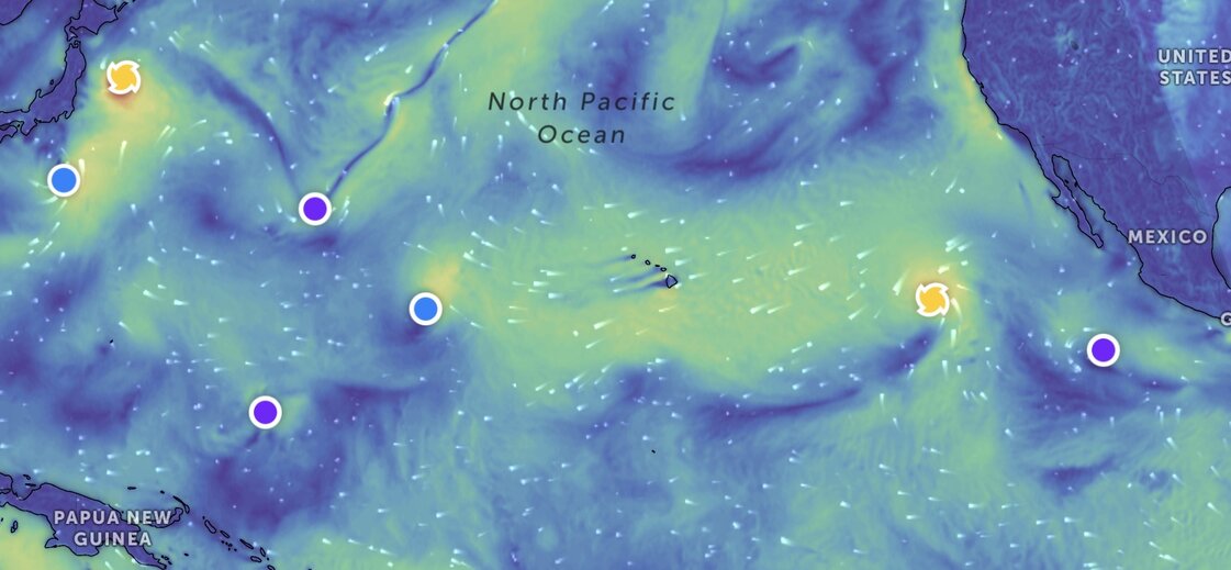
The latest storm news on August 2 said that Hurricane Gil continues to be active in the eastern Pacific but is not expected to threaten land and is likely to weaken rapidly by the end of the week.
Hurricane forecasters at the US National Hurricane Center (NHC) based in Miami said that Hurricane Gil is about 1,865km west-southwest of Baja California peninsula.
Gil has maximum sustained winds of 120 km/h and is moving west-northwest at 31 km/h.
No coastal weather warnings or monitoring have been issued due to the impact of Hurricane Gil.
Hurricane Gil is forecast to weaken from the night of August 2 and may become a tropical depression on August 3.
This is the period of active storms in the eastern Pacific basin.
In addition to Hurricane Gil, Hurricane Iona, a former hurricane, was downgraded from a tropical storm to a tropical depression as it moved in the central Pacific.
Forecasters warn that other storms may form in the coming days in the eastern Pacific.
Forecasters are also monitoring some areas that could become low pressure or tropical storms. Low pressure Invest 92C, located east of storm Iona, encountered unfavorable conditions on August 1 and is currently not expected to develop further.
Another area to watch in southwestern Mexico is likely to develop over the next 7 days. This low pressure area is forecast to have a 50% chance of developing into a tropical depression or tropical storm in the next 2 days and the possibility of strengthening up to 80% in the next 7 days.
Weather conditions are favorable for the gradual development of this system, and there is a possibility that a tropical depression will form later this week or early next week.
The activity of storms and depressions in the western Pacific basin is also very vibrant. Typhoon Krosa (Japan's Ninth Typhoon) is located 83 km southeast of Misawa, Japan and has been moving northeast at a speed of 30 km/h for the past 6 hours.
Meanwhile, tropical depression 13W, a tropical depression near the East Sea, is moving east-northeast at a speed of 31 km/h in the past 6 hours. This system near the East Sea is forecast to strengthen into a storm on August 3.
There are two newly formed depressions in the western Pacific basin, Invest 94W and Invest 95W. Both of these low pressure areas are unlikely to strengthen into tropical depressions in the next 24 hours.
The large number of storms and depressions in the Pacific basin is noteworthy as the large-scale atmospheric model that drives the activity is expected to move into the Atlantic starting next week, according to the FOX Forecast Center.