Low pressure near the Philippines rapidly intensifies into Typhoon Haishen

Thanh Hà |

The low pressure area near the Philippines has been upgraded by the Philippine weather agency to a tropical depression, while the Japanese weather agency has upgraded it to a storm.

The latest storm and low pressure news on the afternoon of July 13th from the Japan Meteorological Agency (JMA) said that the tropical depression located northeast of Palau has strengthened into a tropical storm. The latest storm is internationally named Haishen, storm number 10 named in the Western Pacific Basin (WPAC) in the 2026 storm season.
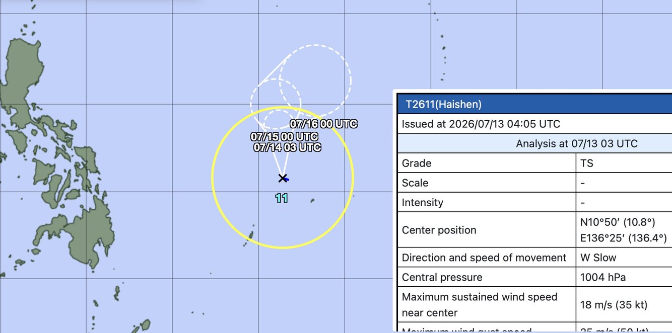
Cơ quan Khí tượng Nhật Bản đã xác định hệ thống gần Philippines là bão nhiệt đới Haishen. Ảnh: JMA
The Japan Meteorological Agency has identified the system near the Philippines as tropical storm Haishen. Photo: JMA

To date, this is the 3rd highest number of storms in this basin, equal to 1965 and the highest number of storms since 2015. Storm name "Haishen" is given by China and means "sea god" in Mandarin.

Meanwhile, the Philippine Atmospheric, Geophysical and Astronomical Services Administration (PAGASA) classifies this system as a tropical depression. The US Navy's Joint Typhoon Warning Center (JTWC) still classifies this system as a low pressure, naming it 97W.

Both PAGASA and JTWC predict that this system will enter the Philippine Area of Responsibility (PAR) in the period from the evening of July 13 to the morning of July 14. After entering PAR, the system is named Josie locally.
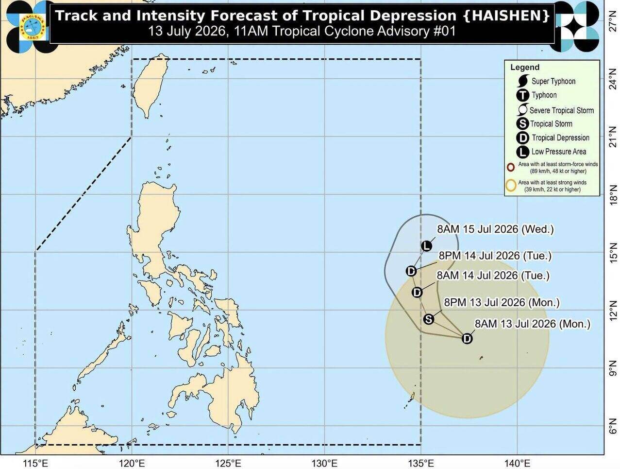
Cơn bão mới nhất sau bão Ba Vì sẽ được đặt tên là Haishen. Ảnh: PAGASA
The latest storm after Typhoon Ba Vi will be named Haishen. Photo: PAGASA

Typhoon forecasters from many agencies all predict that tropical storm Haishen is offshore and is expected not to affect any mainland areas. The latest storm formed immediately after storm Ba Vi is expected to only exist for a short time, possibly lasting 2-3 days before dissipating.

According to PAGASA's midday typhoon bulletin on July 13, tropical depression Haishen is 1,265km east of Eastern Visayas, Philippines. The maximum sustained wind is 55 km/h near the center, gusts up to 70 km/h and central pressure is 1,006 hPa. Haishen is moving west-northwest at a speed of 30 km/h with strong winds spreading up to 480km from the center.

PAGASA predicts that Haishen will continue to move west-northwest in the next 12 hours, entering PAR on the evening of July 13th or the morning of July 14th. When in PAR, the storm will move north, then turn north-northeast until it leaves PAR on July 15th.

Philippine typhoon forecasters note that Typhoon Haishen may strengthen into a tropical storm within the next 12 hours, then gradually weaken due to unfavorable weather conditions.

Thanh Hà
RELATED NEWS

Depression forecast to intensify, may change direction near the Philippines

|

The low pressure near the Philippines is having favorable conditions to strengthen further in the coming days, with the possibility of strengthening at an average level.

Low pressure connects with low pressure after storm Ba Vi, with risk of entering the East Sea

|

A new low pressure area will form immediately after Typhoon Ba Vi, in which there is a possibility of a low pressure area entering the East Sea in the coming days.

Typhoon Ba Vi made landfall twice, only 20 minutes apart

|

Typhoon Ba Vi made landfall in eastern China on the night of July 11, bringing strong winds.

Iran takes responsibility for airstrikes in Oman and Bahrain

|

The Iranian Islamic Revolutionary Guard declared the destruction of US radar systems and military facilities, expanding the scope of attack throughout the Gulf.

Low pressure near the Philippines rapidly intensifies into Typhoon Haishen

|

The low pressure area near the Philippines has been upgraded by the Philippine weather agency to a tropical depression, while the Japanese weather agency has upgraded it to a storm.

Canoe capsizing in Phu Quoc: Transferring patients with underlying diseases to Cho Ray Hospital

|

An Giang - Phu Quoc Special Zone creates all conditions and provides the most active care for the case with a background disease in the canoe capsizing incident, continuing to be transferred to Ho Chi Minh City for treatment.

Close-up of Hoa Binh Hydropower Plant discharging floodwater for the first time in 2026

|

Hoa Binh Hydropower Plant is maintaining flood discharge with 1 bottom discharge gate, creating a turbulent water flow downstream of the Da River and attracting many people to watch.

Depression forecast to intensify, may change direction near the Philippines

Thanh Hà |

The low pressure near the Philippines is having favorable conditions to strengthen further in the coming days, with the possibility of strengthening at an average level.

Low pressure connects with low pressure after storm Ba Vi, with risk of entering the East Sea

Thanh Hà |

A new low pressure area will form immediately after Typhoon Ba Vi, in which there is a possibility of a low pressure area entering the East Sea in the coming days.

Typhoon Ba Vi made landfall twice, only 20 minutes apart

Thanh Hà |

Typhoon Ba Vi made landfall in eastern China on the night of July 11, bringing strong winds.
