The Philippine Atmospheric, Geophysical and Astronomical Services Administration (PAGASA) said that at 2 pm on January 5, low pressure 1 was monitored outside the Philippine Area of Responsibility (PAR).
The center of the low pressure is located at about 6.1 degrees north latitude, 111.5 degrees east longitude, 630km south of Palawan. PAGASA forecasts that the low pressure is unlikely to strengthen into a storm in the next 24 hours.
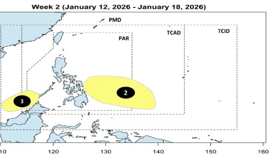
In the week from January 12-18, PAGASA forecasts that 2 new low pressures will continue to appear. Low pressure 2 is expected to appear in the southeastern Philippines, while low pressure 3 appears in the East Sea, south of Palawan, in the same position as low pressure 1. It is forecast that both of these low pressures are unlikely to strengthen into a storm.
Meanwhile, according to the Vietnam National Center for Hydro-Meteorological Forecasting, the latest low pressure in the East Sea combined with the northeast monsoon is affecting many sea areas.
On January 5th, day and night, the northern East Sea area (including Hoang Sa special zone) will have strong northeast winds at level 5, sometimes level 6, gusting at level 7-8. From near dawn on January 6th, the wind will strengthen to level 6, gusting at level 7-8, rough seas, waves 2-4m high.
The central and southern areas of the East Sea (including the Truong Sa special zone) have scattered showers and thunderstorms; in thunderstorms, there is a possibility of tornadoes and strong gusts of wind.
On January 6th, day and night, in the Gulf of Tonkin, northeast wind will be strong at level 6, gusting at level 7 - 8, rough seas, waves 2.5 - 3.5m high.
The Northern East Sea area (including Hoang Sa special zone) has strong northeast winds of level 6, sometimes level 7, gusts of level 8 - 9, strong sea waves, waves 3-5m high.
The area from South Quang Tri to Khanh Hoa and the central East Sea area will have northeast winds gradually strengthening to level 6, gusting to level 7-8, rough seas, waves 3-5m high.
The sea area from Lam Dong to Ca Mau and the western sea area of the South East Sea (including the western sea area of the Truong Sa special zone) will have northeast winds gradually strengthening to level 6, sometimes level 7, gusts of level 8 - 9, strong rough seas, waves 4-6m high.
Regarding the developments of cold air, in the late afternoon and night of January 5, cold air continued to affect places in the Northwest region, then affecting the North Central Coast, Central Central Coast. On land, northeast wind level 2-3, coastal areas level 3-4.
In the Northern region, it will be very cold, with severe cold in some mountainous areas. The North Central region will be cold, with severe cold in some places.
The lowest temperature in this cold air wave in the Northern region, Thanh Hoa and Nghe An is commonly from 10-13 degrees Celsius, the Northern mountainous region 7-10 degrees Celsius, and the high mountainous region in some places below 5 degrees Celsius.
Hanoi area: On the night of January 5, there will be light rain in some places, then no rain. It will be very cold. The lowest temperature in this cold air wave is commonly 10-13 degrees Celsius.


