The Philippine Atmospheric, Geophysical and Astronomical Services Administration (PAGASA) said that low pressure 06f combined with the southwest monsoon is causing scattered showers and thunderstorms in many areas of the Philippines.
According to the latest storm news, at 3:00 a.m. on June 24, the center of the low pressure was at about 14.1 degrees north latitude, 118.4 degrees east longitude, about 210km west-southwest of Cubi Point, Subic Bay International Airport, or 290km west of Tanauan City (Batangas). This location shows that the low pressure area is moving closer to the East Sea, with the possibility of strengthening into a tropical depression in the coming days.
The southwest monsoon is currently affecting Southern Luzon, Visayas, Mindanao and the rest of Central Luzon. The provinces of Pangasinan, Zambales and Bataan are forecast to have scattered showers and thunderstorms due to the direct impact of the low pressure area.
Meanwhile, Metro Manila, Calabarzon, Bicol region, Mimaropa, Western Visayas, Zamboanga peninsula and the rest of Central Luzon will continue to have rain due to the impact of habagat.
PAGASA warns of a high risk of flash floods and landslides in areas with localized heavy rain, especially during strong thunderstorms in the late afternoon.
Meanwhile, the US Joint Typhoon Warning Center (JTWC) named the low pressure near the Philippines as Invest 96W, saying the low pressure has formed along the monsoon trough, west of Mindoro Island (Philippines).
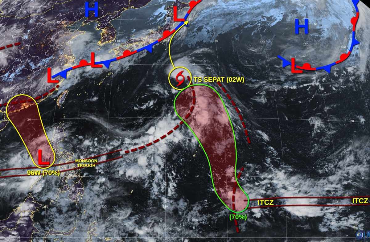
The thunderstorm area around this area is showing clearer signs of organization. Current environmental conditions are assessed to be favorable for development, and the low pressure may strengthen into a tropical depression in the next 1-2 days as the system moves northwest.
It is expected that by June 26, this system will enter the southern mainland of China (western Hong Kong, China), ending the chance of further strengthening. The possibility of tropical cyclone formation in the next 7 days is assessed at a high of 70%.
In addition, disturbance A near Chuuk (Western Pacific) is also likely to become a tropical depression in the next few days. The low pressure is forecast to form along the tropical wave in the middle of the week, then move north, crossing the Mariana Islands east. The chance of a tornado forming in the next 7 days is also at a high of 70%.
With many low pressure areas and tropical disturbances active on and near the East Sea, meteorologists warn that this year's storm season may start earlier than usual, especially in the context of the strong and continuous southwest monsoon.


