Low pressure connects to low pressure after super typhoon Dolphin, may enter the East Sea

Thanh Hà |

It is forecast that 2 low pressure areas will form immediately after the potential super typhoon Dolphin, including 1 low pressure area that may enter the East Sea.

The latest storm and low pressure bulletin from the Philippine Atmospheric, Geophysical and Astronomical Services Administration (PAGASA) on the afternoon of July 28 said that the new low pressure 07e formed from a cloud cluster in Eastern Visayas, Philippines.

At 2 pm on the same day, low pressure 07e was about 315km east of Borongan city, Eastern Samar, Philippines.

The appearance of a new low pressure near the Philippines is consistent with the long-term forecast released on July 27 by PAGASA.

According to this forecast, immediately after Typhoon Dolphin - a storm in the western Pacific basin that is forecast to strengthen into a super typhoon - there are 2 consecutive low pressures forming near the Philippines, of which 1 low pressure will form and enter the East Sea.

The bulletin stated clearly that in the forecast period until August 9, Typhoon Dolphin forming in the western Pacific basin is likely to enter the northeastern boundary of PAGASA's PMD forecast area, heading towards southern Japan.

Philippine weather forecasters point out that in the week from now until August 2, the first low pressure may form at the eastern boundary of PAGASA's TCAD forecast area. This low pressure may persist until the forecast period from August 3 to August 9, with the possibility of moving towards Japan. However, throughout its existence, the low pressure is forecast to have little chance of strengthening into a storm or tropical depression.
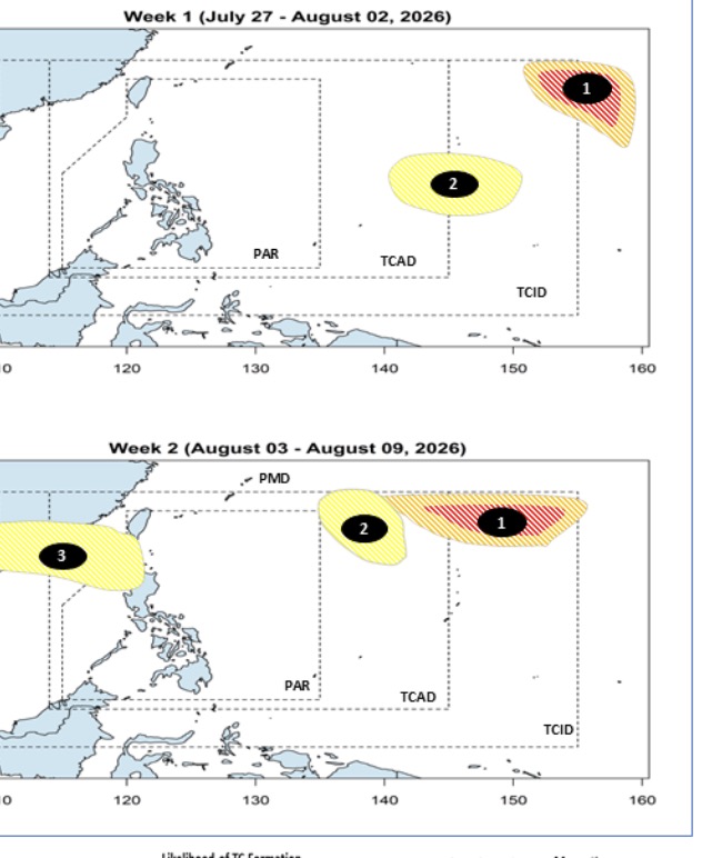
Áp thấp nối áp thấp sau siêu bão tiềm năng Dolphin. Ảnh: PAGASA
Low pressure connects to low pressure after potential super typhoon Dolphin. Photo: PAGASA

Right after this low pressure, a second low pressure is likely to form in the eastern part of the northern Philippines, with little chance of strengthening into a storm or tropical depression. However, the second low pressure is forecast to enter the East Sea, with a very wide area of influence in the northern East Sea, with the ability to affect the weather in China and Vietnam.

According to the latest storm news on the afternoon of July 28 from the US Navy's Joint Typhoon Warning Center (JTWC), Hurricane Dolphin is currently 859km southeast of Wake Island and has moved west at a speed of 20 km/h in the past 6 hours.
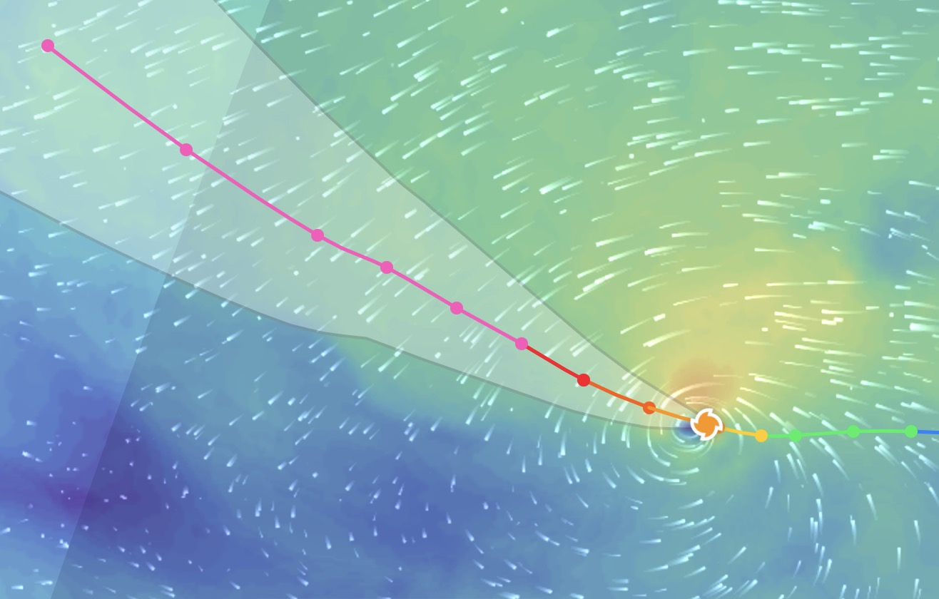
Siêu bão tiềm năng Dolphin chiều 28.7. Ảnh: Zoom Earth
Potential super storm Dolphin on the afternoon of July 28. Photo: Zoom Earth

Currently, Dolphin has rapidly upgraded from a tropical storm to a strong storm. The latest storm of the 2026 storm season is forecast to become a super typhoon with maximum winds forecast to reach 270 km/h.

The Japan Meteorological Agency (JMA) currently forecasts Dolphin is likely to become one of the strongest storms in the western Pacific (WPAC) in recent years.

To date, the storm has not posed a direct threat to any mainland areas. However, the outside rainbands of the storm may begin to affect Wake Island as early as the evening of July 28.

Thanh Hà
RELATED NEWS

Dolphin storm is about to intensify, risk of setting a record in history

|

Hurricane Dolphin may continuously intensify to become one of the most violent storms ever recorded in history.

Dolphin storm forms, likely to strengthen into super typhoon

|

Tropical depression 12W in the Western Central Pacific has strengthened into Typhoon Dolphin, with the potential to strengthen into a super typhoon.

Typhoon Genevieve becomes level 4 hurricane, the strongest since the beginning of the storm season

|

Typhoon Genevieve strongly accelerated into a Category 4 hurricane, becoming the first major hurricane since the beginning of this year's storm season.

Low pressure approaches the East Sea, likely heading towards Vietnam

|

The low pressure near the Philippines is approaching the mainland and is likely to strengthen into a storm, enter the East Sea and may affect Vietnam.

Vietnam national team tickets have not cooled down, ticket scalpers double prices

|

The "black market" ticket price for the Vietnam - Singapore match is offered for sale 1.5 - 2 times the original ticket price.

Ministry of Education and Training informs about the roadmap for organizing high school graduation exams on computers

|

The Ministry of Education and Training has just submitted to the Prime Minister for consideration and approval the Project on Organizing High School Graduation Exams on Computers for the period 2026-2036.

Traffic Police Department proposes to end borrowing the opposite lane to overtake vehicles

|

The Traffic Police Department proposes to change the traffic organization, not allowing borrowing the opposite lane to overtake vehicles.

Trick of "transforming" imported jewelry, showing signs of counterfeiting into domestic products

|

Many imported jewelry products with signs of counterfeiting major brands are turned into domestically crafted goods by sophisticated tricks.

Dolphin storm is about to intensify, risk of setting a record in history

Thanh Hà |

Hurricane Dolphin may continuously intensify to become one of the most violent storms ever recorded in history.

Dolphin storm forms, likely to strengthen into super typhoon

Thanh Hà |

Tropical depression 12W in the Western Central Pacific has strengthened into Typhoon Dolphin, with the potential to strengthen into a super typhoon.

Typhoon Genevieve becomes level 4 hurricane, the strongest since the beginning of the storm season

Thanh Hà |

Typhoon Genevieve strongly accelerated into a Category 4 hurricane, becoming the first major hurricane since the beginning of this year's storm season.

Low pressure approaches the East Sea, likely heading towards Vietnam

Thanh Hà |

The low pressure near the Philippines is approaching the mainland and is likely to strengthen into a storm, enter the East Sea and may affect Vietnam.
