Three fierce storms rise, storms Keli rapidly strengthen

Khánh Minh |

Three consecutive tropical storms formed and rapidly intensified, causing waves in the Pacific Ocean.

While January in the central Pacific near Hawaii rapidly intensified in just a few days, Tropical City Keli also appeared immediately after, and a third storm is on track to form following two previous storms.

Although none are forecast to make landfall directly in the Hawaiian Islands (US), meteorological authorities still warn that the risk may increase in some areas.

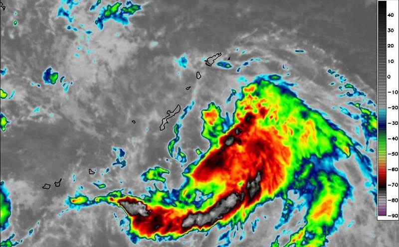
On the morning of July 29 Hawaii time, January 1 - the first in a series of three storms - strengthened into a Category 3 hurricane with winds at the center of the storm reaching 185 km/h and expected to strengthen further during the day.

Du bao duong di cua bao Iona. Anh: NOAA
Forecast of Typhoon Iona's path. Photo: NOAA

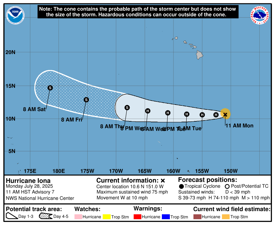
The new tropical depression on the night of July 26 on January 2 quickly strengthened to a Category 1 storm on July 28 with winds of 120 km/h, with the central pressure dropping to 993 mb. The US National Hurricane Center (NHC) said that storm Iona will continue to strengthen over the next 48 hours before gradually weakening due to contact with colder waters.

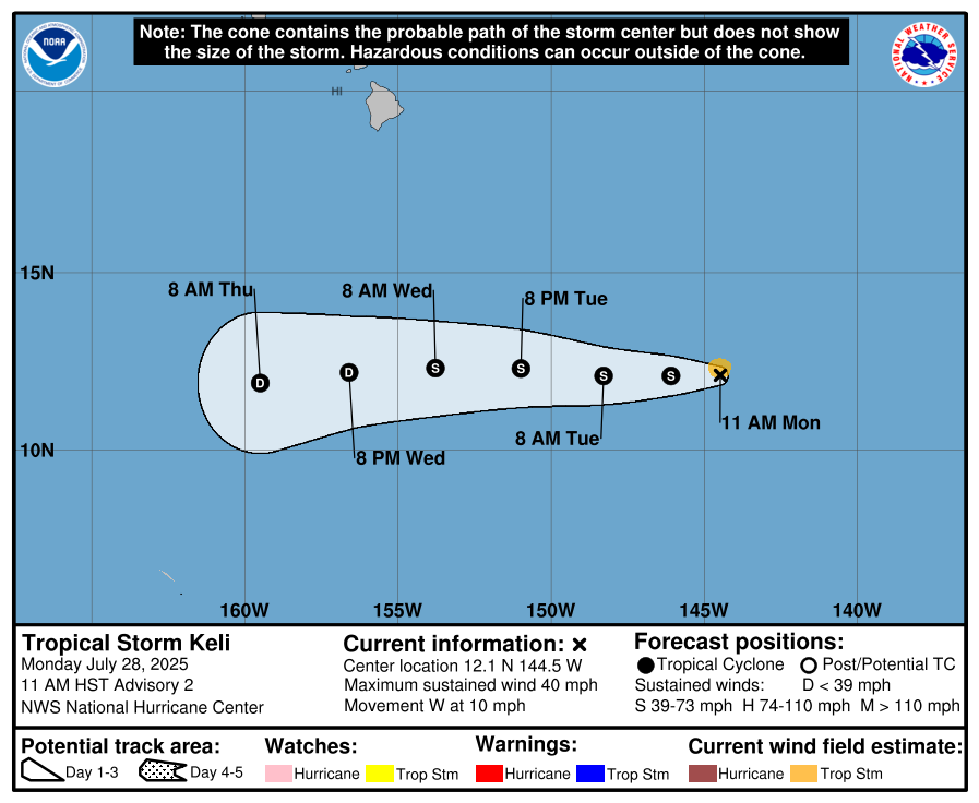
Shortly after January 1, Tropical Storm Keli formed. Although not as strong as Iona, Keli is expected to continue to increase rapidly in the next few days.

Du bao duong di cua bao Keli. Anh: NOAA
Forecast of Typhoon Keli's path. Photo: NOAA

Behind Keli, a rapidly developing tropical disturbance is likely to become the third storm in this rare chain.

Although all three storms maintain their trajectory westward and away from the Hawaiian Islands, the indirect impact of these tropical storm systems could still affect local weather.

3 storms/rupture a row in the central Pacific Ocean, near Hawaii, on July 29, 2025. Video: NOAA

According to the US National Weather Service (NWS) in Honolulu, trading winds will increase slightly as storms approach Hawaii. This phenomenon may reduce the altitude of the subtropical layer, limiting clouds and rain from July 30 to August 1.

Although the weather forecast is not too harsh, the NWS warns of a risk of forest fires at near the danger level in some dry areas of Maui and the Big Island. As storms pump moisture south, dry air flows may overflow the islands. Some places on the windy slopes may reach the minimum humidity for a few hours each afternoon. However, the wind speed is not expected to exceed the danger threshold, so an official forest fire warning has not been issued.

On July 29, the islands in Hawaii continued to experience hot and humid weather as the trough moved through, combined with weak sea winds in the windless areas. However, from July 30, the high pressure area will return, returning the weather to a dry, stable state, helping to reduce the risk of forest fires in the short term.

Although tropical storms do not make landfall directly, NWS emphasizes that it will continue to closely monitor the development of this storm chain, especially in the context of prolonged drought and the risk of forest fires in Hawaii still present.

Khánh Minh
RELATED NEWS

Forecast of storms and low pressure in the storm center near the East Sea

|

The latest storm news shows that there are currently 3 tropical cyclones active with a new pressure that is likely to develop in the storm center near the East Sea.

Comay No. 4 is a strange storm that has never been seen before, reborn many times

|

Comay No. 4 suddenly strengthened after weakening into a tropical depression and is expected to reborn once again after dissipating.

Forecast of affected areas and time of severe storm Krosa making landfall

|

According to the latest storm forecast, Typhoon Krosa has strengthened into a major and intense storm with wind gusts of 135 km/h.

Nearly 200 workers in Son La have received full salaries

|

Son La - Nearly 200 workers owed late construction costs for the Chieng Khoong Inter-level Boarding School Project have received full wages.

The aura of the football field nurtures the personal brand of the player

|

With a breakthrough tournament in their football career, many football players have changed their lives and have a full life.

Vietnamese workers abroad eagerly welcome Tet in homesickness

|

Every time peach branches and apricot branches begin to show off their colors in their homeland, in a distant corner of the sky, many Vietnamese workers celebrate Tet with a feeling of emotion that is hard to name.

Completing the year-end sea trip, Hung Yen fishermen reunite with their families

|

Hung Yen - Thai Thuy commune fishermen complete the last sea trip of the year, pack their gear from the 23rd of Tet to return to shore to reunite with their families, ending a year of sticking to the sea to earn a living.

Vietnam emerges as a new Asian tiger candidate

|

Vietnam maintains impressive growth momentum, gradually affirming its position as a rising economy in Asia.

Forecast of storms and low pressure in the storm center near the East Sea

Khánh Minh |

The latest storm news shows that there are currently 3 tropical cyclones active with a new pressure that is likely to develop in the storm center near the East Sea.

Comay No. 4 is a strange storm that has never been seen before, reborn many times

Song Minh |

Comay No. 4 suddenly strengthened after weakening into a tropical depression and is expected to reborn once again after dissipating.

Forecast of affected areas and time of severe storm Krosa making landfall

Ngọc Vân |

According to the latest storm forecast, Typhoon Krosa has strengthened into a major and intense storm with wind gusts of 135 km/h.