The most affected area of the 2 low pressure areas after storm No. 4, storm Krosa seems to have strengthened

Song Minh |

Although Comay and Franciso have weakened, they still combine with Typhoon Krosa to bring heavy rain and strong winds throughout the weekend.

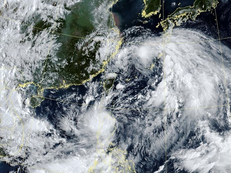
This weekend, Taiwan's weather will be dominated by the two tropical depression systems of San Francisco and Comay, causing the northern and central regions of the island to experience heavy rain, strong winds and sudden showers until the end of July 27.

According to weather forecaster Ngo Duc Vinh ( Daniel Wu) of the Taiwan Meteorological Administration (CWA), these two tropical depressions are moving around each other in the clockwise direction under the guidance of the monsoon, creating a large circulation surrounding Taiwan (China). Meanwhile, the southern provinces of the island will only have scattered showers or thunderstorms locally.

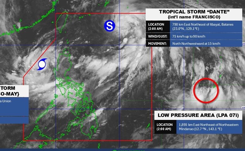
According to the latest storm information from the CWA, tropical depression Francisco is in the west of the Ryukyu Islands (Japan) and is slowly moving north of Taiwan (China). The structure of this system is quite loose, almost no longer having significant convection due to being wrapped in dry air in the East China Sea. Francisco's winds are currently only around 37-46 km/h. Francisco is likely to completely disband on July 26.

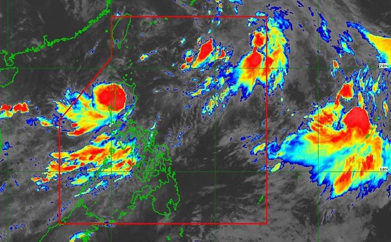
Meanwhile, tropical depression Comay is still moving northeast and may sweep across Luzon Island (Philippines) as it weakens. However, even if it does not make landfall in Taiwan (China), the influence of Comay's circulation still causes the North and Central regions of this island to suffer moderate to heavy rains, accompanied by strong winds and humid air.

Anh ve tinh cua ap thap nhiet doi Comay va ap thap nhiet doi Francisco ngay 26.7.2025. Anh: CWA
Satellite image of tropical depression Comay and tropical depression San Francisco on July 26, 2025. Photo: CWA

Meanwhile, the CWA confirmed that Tropical Storm Krosa has formed northwest of Guam, becoming the ninth named storm this year. Krosa is gradually strengthening despite harsh environmental conditions. At 2:00 a.m. on July 26, the center of the storm was at 17.5 degrees north latitude; 143.1 degrees east longitude, wind speed 85 km/h, gust 105 km/h, moving north-northeast at a speed of 10 km/h.

Satellite stations have recorded that Krosa has begun to form a small eye-like structure and the central convective system (CDO) has very low cloud temperatures, down to -90 degrees Celsius, signaling a potential storm to strengthen. However, due to the impact of strong wind shear and dry air, the storm only gradually intensified.

Krosa does not threaten Taiwan (China) because it is moving towards the northern sea and will change direction to the Northeast in the next few days. However, the Northern Mariana Islands may be affected by strong gusts of wind, heavy rain and rough seas.

On the East Sea, the Vietnam National Center for Hydro-Meteorological Forecasting said that on the day and night of July 26, the eastern sea area of the North East Sea will have winds of level 6, gusts of level 7-8, rough seas. From noon to afternoon, the wind intensity will gradually decrease.

The Central East Sea area and the sea area from Gia Lai to Ho Chi Minh City will have winds of level 6, gusting to level 7-8. Rough seas.

The sea area from Dong Thap to Ca Mau and the South East Sea area (including Truong Sa special zone) has winds of level 5, sometimes level 6, gusting to level 7-8. Rough seas.

During the day and night of July 27, the sea area south of the North East Sea (including Hoang Sa special zone); the Central East Sea area; the sea area from Gia Lai to Ho Chi Minh City will have strong southwest winds of level 6, gusting to level 7-8, waves 2-4m high, rough seas.

Song Minh
TIN LIÊN QUAN

Storm No. 4 made a second landfall this morning, 2 other storms are gathering in the storm center near the East Sea

|

Typhoon No. 4 Comay made its second landfall on the morning of July 25, with the strongest wind in 16 years in Luzon, Philippines.

Forecast of when storm No. 4 in the East Sea and storm San Francisco will make landfall

|

The storm duo, including Typhoon No. 4 in the East Sea and Typhoon Francisco, are causing heavy rain, waves up to 14m high, and unfavorable weather for the North East Sea and the Philippines.

Storm overlaps with storm near the East Sea right after storm No. 3 Wipha

|

Right after storm No. 3 Wipha in the East Sea, on July 23, storm Francisco (Dante) formed and storm Emong was waiting to follow.

The quintessence converged at the largest Vietnamese festival ever in Russia

|

Russia - For the first time, the Vietnam Cultural Festival took place at Red Square in the heart of the Moscow Capital. The festival lasts for 10 days, until August 3.

Proposal to establish another commune-level professional department in Hanoi and specific provinces

|

Hanoi - The Department of Home Affairs proposed to allow the city and some localities with large scale and development characteristics to establish an additional professional department at the commune level.

The psychology of blaming victims after the Ha Long Bay tragedy and the deterioration of compassion

|

After the tragic accident in Ha Long Bay, instead of sympathy, many people blamed the victims. This reflects the erosion of compassion.

Starting construction of trade union social housing project in Dong Thap province

|

Dong Thap - On the morning of July 26, in Dong Thap, the groundbreaking ceremony for the trade union social housing project under the trade union institution construction project in My Tho Industrial Park, Trung An Industrial Cluster took place.

The Navy will parade at sea in Khanh Hoa with the appearance of the Kilo 636 tank ofapia

|

The Navy is developing a plan to organize a parade of the armed forces at sea with the appearance of the Kilo 636 tank of water surface ships.

Storm No. 4 made a second landfall this morning, 2 other storms are gathering in the storm center near the East Sea

Khánh Minh |

Typhoon No. 4 Comay made its second landfall on the morning of July 25, with the strongest wind in 16 years in Luzon, Philippines.

Forecast of when storm No. 4 in the East Sea and storm San Francisco will make landfall

Song Minh |

The storm duo, including Typhoon No. 4 in the East Sea and Typhoon Francisco, are causing heavy rain, waves up to 14m high, and unfavorable weather for the North East Sea and the Philippines.

Storm overlaps with storm near the East Sea right after storm No. 3 Wipha

Ngọc Vân |

Right after storm No. 3 Wipha in the East Sea, on July 23, storm Francisco (Dante) formed and storm Emong was waiting to follow.