Comay No. 4 is a strange storm that has never been seen before, reborn many times

Song Minh |

Comay No. 4 suddenly strengthened after weakening into a tropical depression and is expected to reborn once again after dissipating.

According to the latest storm information from the Philippine Atmospheric, Geophysical and Astronomical Services Administration (PAGASA), at 2:00 a.m. on July 28, the center of Comay was at about 26.7 degrees north latitude; 128.3 degrees east longitude, 930km northeast of the northernmost tip of Luzon.

Maximum winds near the center of the storm are 75 km/h, gusting to 115 km/h. The storm is moving northeast at 10 km/h.

Comay is forecast to continue to strengthen and is likely to make landfall in eastern China within the next 48 hours.

According to the Joint Typhoon Warning Center (JTWC) and the Japan Meteorological Agency (JMA), the center of Comay is about 150km east of Japan's Okinawa Island. The storm is almost stuck in the large monsoon circulation west of Okinawa - an area with little direction.

The JMA said that on July 27, Comay (formerly the fourth typhoon in the South China Sea) re-strengthened off Okinawa after weakening into a tropical depression over the weekend. This is the first time since 2018 that a typhoon has been upgraded by the Japan Meteorological Agency after weakening into a tropical depression.

Despite the damaged storm structure, with a clear circulation and a distance from the main thunderstorm area, the latest satellite data still recorded strong winds in the north and northeast of the storm's center.

Du bao duong di cua bao Comay. Anh: JMA
Forecast of Comay's path. Photo: JMA

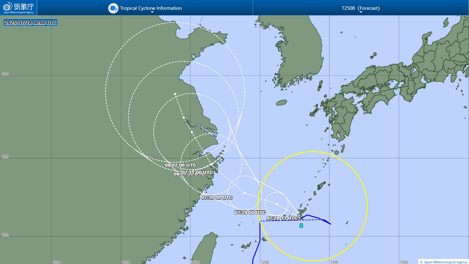
As atmospheric conditions ahead of Comay are still considered favorable, the storm is likely to strengthen slightly in the next 24 hours as it moves west-northwest, enters the East China Sea and is expected to make landfall in eastern China on the morning of July 30.

After making landfall, Comay is expected to rapidly weaken, becoming a tropical depression on July 31 and dissipating soon after.

However, some forecast models predict that Comay could reborn again as the remnants of the storm move south of the Hoang Hai sea on August 1.

Although this possibility is not high, meteorological experts emphasize that Comay was a rare case - degraded and then upgraded to a storm again. This is the first time this phenomenon has occurred in Japan since 2018.

There are currently no official warnings on land, but the JMA and JTWC warn that heavy rain and strong gusts of wind will begin affecting Okinawa Prefecture and Ryukyu Islands (Japan) from the evening of July 28. There is a possibility of flash floods and landslides in high mountainous terrain.

In Okinawa Prefecture, local authorities have warned residents to be on guard against prolonged heavy rains and closely monitor weather forecasts. Meanwhile, US military bases in Okinawa are guided to update the situation through the Stars & Stripes Pacific Storm Tracker system.

Song Minh
TIN LIÊN QUAN

Forecast of affected areas and time of severe storm Krosa making landfall

|

According to the latest storm forecast, Typhoon Krosa has strengthened into a major and intense storm with wind gusts of 135 km/h.

This year's storm forecast is stronger and more frequent

|

According to the latest storm forecasts, this year's storm season sees the frequency of landfall storms increasing in intensity.

The most affected area of the 2 low pressure areas after storm No. 4, storm Krosa seems to have strengthened

|

Although Comay and Franciso have weakened, they still combine with Typhoon Krosa to bring heavy rain and strong winds throughout the weekend.

Localities will screen and classify civil servants, opening new recruitment opportunities

|

According to the Minister of Home Affairs, there will be documents directing localities to screen civil servants, thereby opening up recruitment opportunities and adding new tasks to meet the requirements of the task.

Quickly arrange and rearrange the team of civil servants, perfecting commune-level leaders

|

The Prime Minister requested to quickly arrange and reassign the appropriate team of cadres and civil servants, especially to perfect the leadership at the commune level.

Destroyed after floods, people in the mountainous areas of Son La struggle to rise up

|

Son La - The horrific flood on the evening of July 26 with the sweep of soil and rocks that collapsed caused great damage to people and property.

Liquidity explodes, stocks hit a historic peak after 25 years

|

The VN-Index set the highest score in the trading history of the stock market with a record liquidity of nearly 2 billion USD.

Electric vehicle charging stations flourish in Ho Chi Minh City

|

HCMC - The shortage of legitimate charging infrastructure has caused many households, cafes, and parking lots in HCMC to set up charging stations for electric vehicles.

Forecast of affected areas and time of severe storm Krosa making landfall

Ngọc Vân |

According to the latest storm forecast, Typhoon Krosa has strengthened into a major and intense storm with wind gusts of 135 km/h.

This year's storm forecast is stronger and more frequent

Song Minh |

According to the latest storm forecasts, this year's storm season sees the frequency of landfall storms increasing in intensity.

The most affected area of the 2 low pressure areas after storm No. 4, storm Krosa seems to have strengthened

Song Minh |

Although Comay and Franciso have weakened, they still combine with Typhoon Krosa to bring heavy rain and strong winds throughout the weekend.