
The latest storm and low pressure news from the Philippine Atmospheric, Geophysical and Astronomical Services Administration (PAGASA) updated at 2:00 AM on September 17 (Philippines time) shows that low pressure LPA 09d has officially strengthened into a tropical storm and is named Dujuan.
Currently, Typhoon Dujuan is operating outside the Philippine Area of Responsibility (PAR). The typhoon is about 2,975km east of Luzon Island, at 17.6 degrees North latitude and 149.8 degrees East longitude. Dujuan has winds of 75 km/h, gusts of 90 km/h and moves in a north-northeast direction at a speed of about 20 km/h.
According to the forecast map, Typhoon Dujuan tends to continue to strengthen and move mainly north, then slanted to the northwest. From around September 20, the typhoon tends to shift direction to northeast and continue to move east, towards the sea near Japan between September 20-22.
The storm's wind speed is forecast to increase from about 72 km/h on September 17 to 83 km/h in the afternoon of the same day and about 91 km/h in the early morning of September 18. By September 19, the forecast wind speed will reach about 107 km/h and may remain around this level in the following days. The central pressure is forecast to decrease from about 990 hPa to 975 hPa.
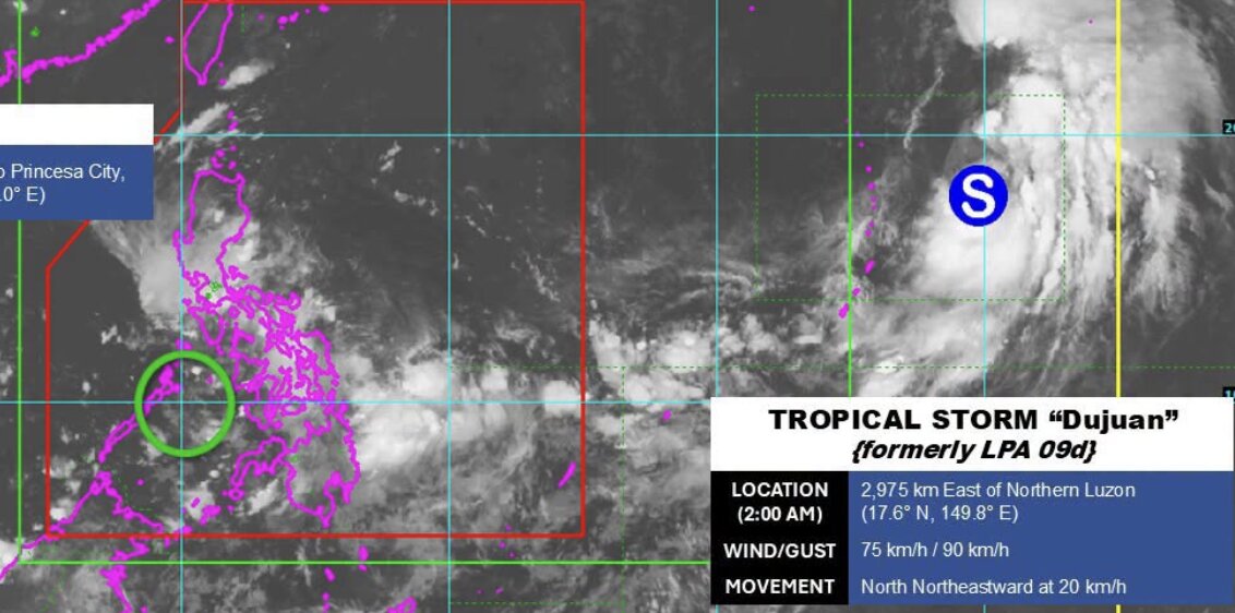
Meanwhile, a new low pressure called LPA 09e is being monitored by PAGASA inside PAR. At 2:00 AM on September 17, this low pressure was located about 135km east of Puerto Princesa city, Palawan province (Philippines), at 9.8 degrees North latitude and 120 degrees East longitude. PAGASA assesses that LPA 09e is unlikely to strengthen into a tropical depression in the next 24 hours.
Regarding weather forecasts, PAGASA forecasts that many areas in Visayas, Mimaropa, Bicol region, Zamboanga peninsula, Barmm, northern Mindanao and some provinces of Luzon, Mindanao will have cloudy skies, scattered rain and thunderstorms. Moderate rain, sometimes heavy rain can cause flash floods or landslides. Other areas of Mindanao and Luzon have showers or localized thunderstorms, also posing a risk of flash floods and landslides when strong thunderstorms occur.
In southern Luzon, Visayas and Mindanao, winds are forecast to be light to moderate, in the southwest to southeast direction. Sea areas have waves 0.6-2.5m high. The remaining areas of Luzon have light to moderate winds, in the northeast to east direction, with similar wave heights.
PAGASA recommends that people continue to update the latest bulletins on the developments of Typhoon Dujuan and low pressure LPA 09e.


