
The latest typhoon and tropical depression news on the morning of July 23rd from the Philippine Atmospheric, Geophysical and Astronomical Services Administration (PAGASA) said that tropical depression Kiyapo maintained its intensity as it moved northwest over the Philippine Sea in the eastern Central Luzon region, Philippines.
Currently, the center of the tropical depression Kiyapo is 950km east of Central Luzon, Philippines. The tropical depression near the East Sea currently has maximum sustained winds of 45 km/h near the center, gusts up to 55 km/h and a central pressure of 1002 hPa. The tropical depression Kiyapo is moving northwest at a speed of 20 km/h. Strong winds at the tropical storm level are spreading to 400km from the center of the low pressure.
Previously, the low pressure near the Philippines officially strengthened into the tropical depression Kiyapo from the evening of July 22. At that time, the tropical depression Kiyapo was 1,080km southeast of Luzon, with maximum sustained winds, gusts similar to PAGASA's data announced on the morning of July 23, but moving in a northwest direction at a speed of up to 25 km/h.
Tropical depression Kiyapo will continue to move west-northwest until July 25 towards the Luzon Strait before turning northwest in the remaining forecast period.
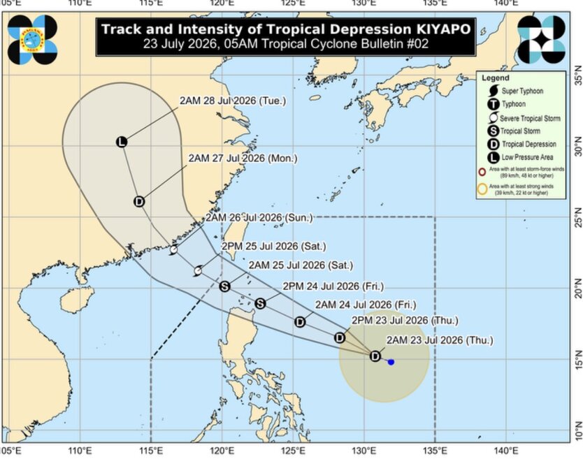
According to the latest typhoon forecast from PAGASA, Kiyapo will gradually strengthen as it moves over the Philippine Sea and may become a tropical storm on July 24. This typhoon near the East Sea will continue to strengthen as it passes through the northernmost part of Luzon and may further intensify into a strong tropical storm after passing through the Babuyan Islands. It is expected that the typhoon will weaken when it makes landfall in southern mainland China and move deeper inland.
Regarding the detailed forecast path of Typhoon Kiyapo, Philippine typhoon forecasters said that the center of Typhoon Kiyapo may approach the northeastern area of Cagayan in the middle of the morning and afternoon of July 24, then may approach or make landfall in the Babuyan archipelago area in the middle of the afternoon and evening of July 24. It is forecast that Kiyapo will enter the East Sea from July 24 and leave the Philippine forecast area in the morning or noon of July 25.
The latest storm bulletin from the US Navy's Joint Typhoon Warning Center (JTWC) also forecasts that the system near the Philippines that this agency identified as low pressure 92W (name Kiyapo in the Philippines) is likely to strengthen into a tropical storm in the next 24 hours. The maximum sustained wind speed of 92W is about 35–45 km/h. The system is in the stage of transitioning from low pressure to tropical depression and is gradually strengthening.
JTWC storm forecasters said that regional analysis shows a favorable environment for the development of the system, with moderate winds, strong winds heading west at high altitudes and warm sea temperatures, from 29-30 degrees Celsius. Global forecast models all agree that 92W will continue to strengthen in the next 24 hours.


