According to the storm forecast bulletin of the Philippine Atmospheric, Geophysical and Astronomical Services Administration (PAGASA), at 3:00 a.m. on August 10, the center of Typhoon Podul was at about 21.5 degrees North latitude, 139.9 degrees East longitude, operating outside the Philippine Forecast Area (PAR), about 1,875km east of the northernmost tip of Luzon Island.
Maximum winds near the center of the storm are 110 km/h, gusting to 135 km/h, moving west at a speed of about 15 km/h. The storm-force wind zone has a radius of up to 280km from the center.
Weather forecast for 10.8: Ilocos, Batanes and Babuyan Islands will have cloudy skies with scattered showers and thunderstorms, with the risk of flash floods or landslides during moderate to heavy rains.
Metro Manila, Zambales, Bataan, Cavite, Batangas, Occidental Mindoro and Palawan: Rarely to cloudy, with scattered showers or thunderstorms, with the risk of flash floods and landslides during strong thunderstorms.
In the rest of the Philippines, the weather is similar to scattered showers or thunderstorms due to local thunderstorms.
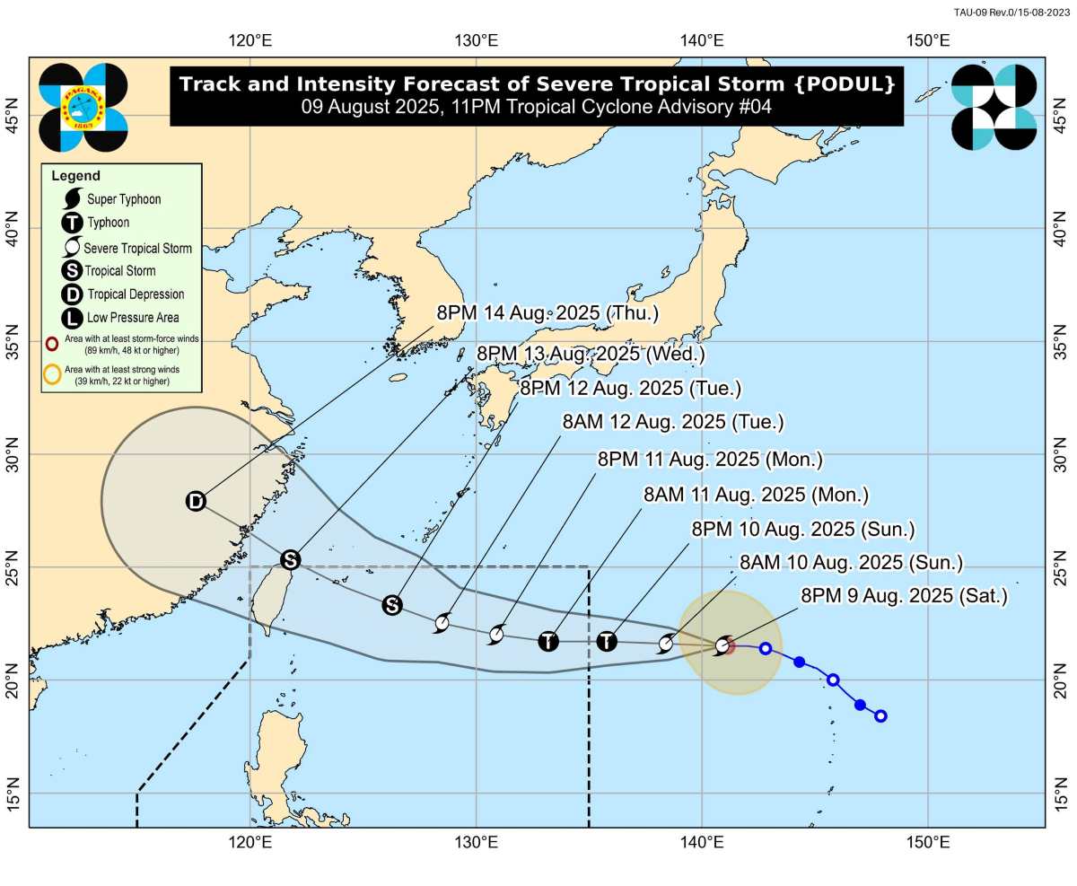
According to the US Joint Typhoon Warning Center (JTWC), Typhoon Podul is likely to reach typhoon level tonight (August 10). However, from the evening of August 12, when approaching northern Taiwan (China), the storm will encounter unfavorable atmospheric conditions, causing its intensity to weaken rapidly from August 13 and continue to decrease in the following days.
The Central Meteorological Administration of Taiwan (CWA) is expected to issue a sea warning for Typhoon Podul as early as the morning of August 12.
If Podul maintains its strong intensity and moves closer, the storm could bring heavy rain to northern coastal areas of Taiwan (China) on August 13, with the heaviest rain expected to fall on August 13-14. After that, rainfall in northern and central Taiwan (China) will gradually decrease as the storm moves away, but showers may continue in the south and east.
Before the storm, from August 10-12, the weakening of the subtropical high pressure in the Pacific will cause many thunderstorms in the western and eastern mountainous areas of Taiwan (China) in the afternoon, posing a potential risk of local heavy rain.
In the East Sea, according to the Vietnam National Center for Hydro-Meteorological Forecasting, on the morning of August 10, the South East Sea (including the special waters of Truong Sa), Ca Mau to An Giang, and the Gulf of Thailand will have scattered showers and thunderstorms.
Day and night on August 10, the North East Sea area (including Hoang Sa special zone), South East Sea area (including Truong Sa special zone), the sea area from Lam Dong to Ca Mau, Ca Mau to An Giang and the Gulf of Thailand, will have scattered showers and thunderstorms. There is a possibility of tornadoes and strong gusts of wind. Wave height from 2-3m
All ships operating in the above areas are at risk of being affected by tornadoes, strong gusts of wind and high waves.
Regarding rain forecast: Day and night of August 10, the mountainous areas of the North will have scattered showers and thunderstorms, locally heavy rain of 10-30mm, some places 80mm (concentrated in the early morning, evening and night).
The Central Highlands, the South and the East of Lam Dong will have rain, moderate rain and scattered thunderstorms, locally heavy rain of 15-40mm, some places over 80mm.