As the Atlantic hurricane season enters its most intense phase, meteorologists are also monitoring two other storms in the Pacific Ocean at the same time.
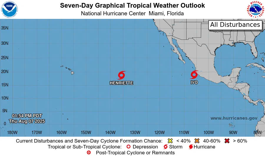
The latest storm information from the US National Hurricane Center (NHC) said that on the morning of August 9, tropical storm Ivo was about 620km southeast of the southernmost tip of Baja California (Mexico), moving northwest at a speed of 34 km/h, with the strongest wind near the center of the storm at 96 km/h, gusting more strongly.
They are forecast to strengthen into a hurricane on August 9, starting to move away from the coast of Mexico and turning westward, away from land. Rainfall of 50-100mm, locally 150mm, could fall on the states of Guerrero, Michoacan de Ocampo and Colima, accompanied by large waves and dangerous offshore flows.
In addition to Ly counties, Henriette is also moving about 1,925km east of Hawaii, with winds of 72km/h. Hurricane Henriette is forecast to change direction to the northwest over the weekend and not directly affect Hawaii.
In the North Atlantic, Dexter still maintains winds of 96 km/h, when it is 628 km south-southeast of Newfoundland ( Canada). The Dexter will strengthen on August 8 but will weaken over the weekend, not threatening land.
The US National Oceanic and Atmospheric Administration (NOAA) continues to forecast that the 2025 hurricane season will be more active than average, with 13-18 named storms, of which 5-9 may become major hurricanes, and 2-5 become strong Category 3-5 hurricanes.
So far, the 2025 hurricane season has produced four named Andrea, Barry, Chantal and Dexter. The next name on the list is Erin. The average Atlantic hurricane season has a first on August 11.
No storm is the same, emphasized Ken Graham, director of the National Weather Service. Each storm can cause a fatal risk to both coastal areas and inland areas. Have a plan and know what actions to take before, during and after the storm.
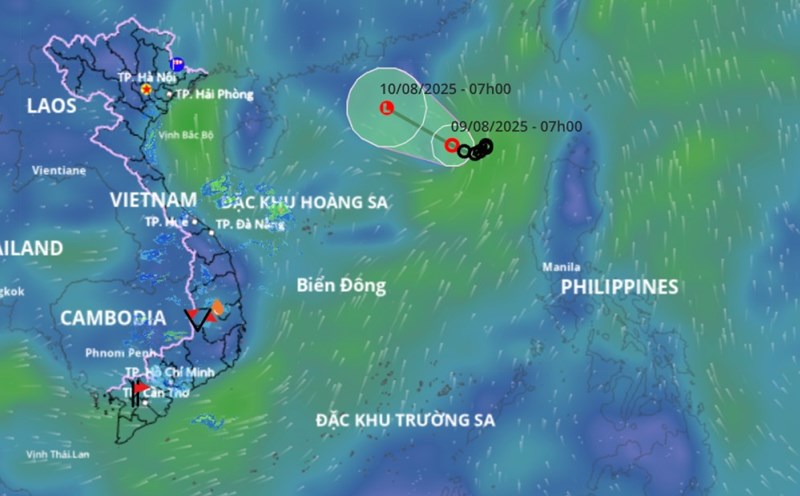
In the East Sea, the Vietnam National Center for Hydro-Meteorological Forecasting is monitoring a tropical depression in the eastern sea of the North East Sea.
It is forecasted that by 1:00 p.m. on August 9, the center of the tropical depression will be at about 19.6 degrees North latitude, 115.5 degrees East longitude, about 480km northeast of Hoang Sa archipelago. The strongest wind near the center of the tropical depression is level 6, gusting to level 8, moving in the west-northwest direction, traveling about 10km per hour.
Dangerous area: 18.0-21.0 degrees North latitude; 114.5-112.5 degrees East longitude. The eastern sea area of the North East Sea is at risk of level 3 natural disasters.
It is forecasted that by 1:00 p.m. on August 10, the center of the tropical depression will be at 20.9 degrees North latitude, 114.2 degrees East longitude; in the northern sea area of the North East Sea. The intensity decreases to below level 6.