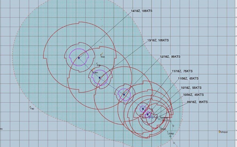
The latest typhoon news on the afternoon of April 12 from the US National Weather Service (NWS) said that Typhoon Sinlaku may strengthen into a super typhoon with winds up to about 241 km/h as it approaches the Mariana Islands area.
Sinlaku may reach super typhoon status (about 241 km/h, equivalent to level 4 strong) as it approaches the area. The wide circulation of the typhoon will cause increasingly strong gusts, heavy to very heavy rain and strong sea waves from the evening of April 13" - the bulletin stated.
Guam Island has been placed in a tropical storm warning status since 2 pm on April 12, while still maintaining storm monitoring status.
A tropical storm warning means that strong winds from 63-117 km/h can occur within 24 hours. While storm monitoring means that storm conditions, including winds from 119 km/h or more, are likely to occur within 48 hours.
The US National Weather Service also emphasized that the wide circulation of Typhoon Sinlaku will continue to cause strong gusts of wind, heavy rain to torrential rain and more violent rough seas on the evening of April 13.
Although the latest trajectory shows that the storm tends to slightly sway north as it moves near Rota Island, strong tropical storm winds causing damage are still forecast to affect Guam and other islands in the Mariana Islands from the end of April 13.
At 1:00 PM on April 12, the center of Typhoon Sinlaku was at about 10.2 degrees North latitude, 151.0 degrees East longitude, about 764km east-southeast of Guam. The latest typhoon of the typhoon season is moving north-northwest at a speed of about 14 km/h, with maximum sustained winds of about 201 km/h.
According to the Joint Information Center, due to the impact of Typhoon Sinlaku, Guam may begin to record strong winds from 63 km/h or more on the evening of April 13 and this situation may last continuously until the evening of April 15.
Also forecasting the developments of Typhoon Sinlaku, the Philippine Atmospheric, Geophysical and Astronomical Services Administration (PAGASA) said that Sinlaku may enter the Philippine Area of Responsibility (PAR) next week.
However, the possibility of the storm directly affecting the mainland of the Philippines is low.
PAGASA weather expert Veronica Torres stated in the storm bulletin: "The possibility of the storm entering PAR next weekend cannot be ruled out. However, the possibility of landfall is low and no direct impact on any area of the Philippines has been seen yet.
Currently, PAGASA's typhoon forecasters recorded Typhoon Sinlaku about 2,745km northeast of Mindanao, Philippines, still outside PAR. The maximum sustained wind is about 150 km/h, gusts up to 185 km/h. The typhoon is moving slowly north.
If entering PAR, Typhoon Sinlaku will be named Caloy in its local name.