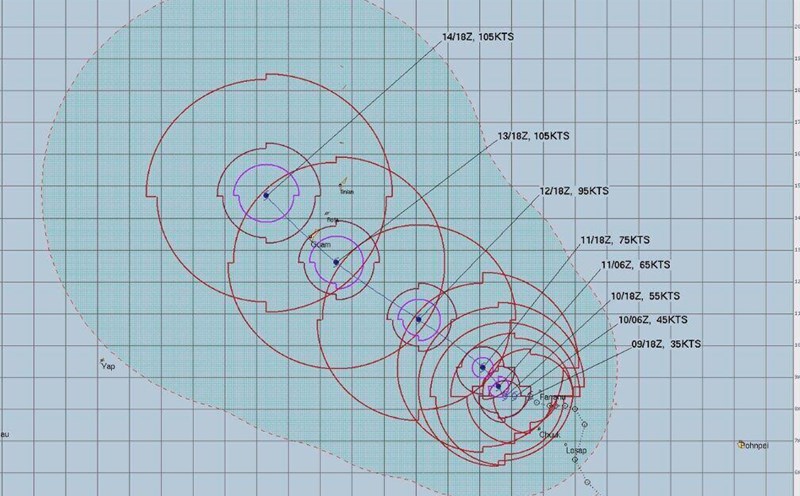
Latest typhoon news from the United Information Center in Guam at 10:30 am on December 12. 4 typhoon Sinlaku's path has slightly shifted northward and is likely to pass through the north of Rota Island.
Any change in the storm's path could still cause Guam to suffer very strong storm winds, equivalent to Category 4 storms, with wind speeds up to 193-209 km/h.
Currently, no secondary weather system is being monitored after Typhoon Sinlaku.
Typhoon Sinlaku is forecast to move through the Mariana Islands area with a Category 4 storm intensity.
Previously, international meteorologist Tyler Roys of AccuWeather said that Typhoon Sinlaku could reach intensity equivalent to a Category 3 storm when approaching or sweeping through southern Guam island early next week.
This storm is a serious threat to Guam Island. Sinlaku will cause devastating winds and heavy rain leading to flooding, likely causing power outages and damage to infrastructure" - Mr. Tyler Roys said.
The US Coast Guard is warning people in this territory to take proactive precautions, and at the same time dispatching patrol boats to leave Apra port to be ready for emergency response after the storm, including search and rescue missions.
The Joint Typhoon Warning Center (JTWC) of the US Navy said that Sinlaku may approach Guam from the night of April 13 to April 14. The US National Weather Service in Guam also warned that the storm may soon head towards the Mariana Islands.
Storm warnings, with the possibility of strong winds from 119 km/h or more in the next 48 hours, have also been extended to neighboring islands including Rota, Tinian and Saipan. Guam authorities said they are ready to open emergency shelters.
Flash floods could become a serious problem in Guam because Typhoon Sinlaku could pour heavy rain in a short time. Water-saturated soil also increases the risk of landslides," warned storm forecaster Tyler Roys.