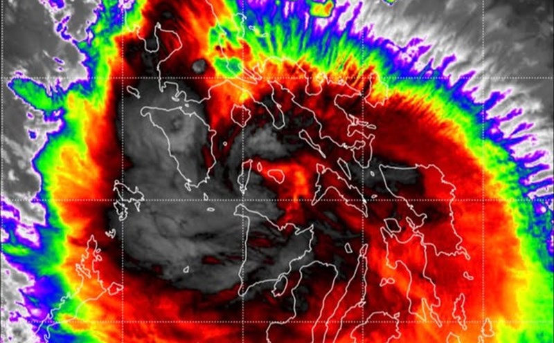
The Philippine Atmospheric, Geophysical and Astronomical Services Administration (PAGASA) said that this morning, storm Bualoi (storm No. 10) is continuing to strengthen in the West Philippine Sea (South China Sea).
At 4:00 a.m. on September 27, the center of the storm was at 14.2 degrees North latitude, 116.2 degrees East longitude, about 580km East Southeast of Hoang Sa Special Zone. Maximum winds near the center of the storm are 120 km/h, gusting up to 150 km/h and central pressure is 970 hPa.
The storm is moving west-northwest at a speed of 30 km/h. The affected area is up to 400km from the center of the storm.
As of September 26, at least 10 people have been confirmed dead in the Philippines after Typhoon Bualoi made landfall in Eastern Samar on September 25 before entering Masbate and sweeping through the Bicol region. At least 13 others were reported missing, mainly fishermen from three Central provinces, who were still unknown after being at sea before the storm made landfall.
The storm has left devastating consequences, forcing thousands of people to evacuate, who have already struggled with the devastation of Super Typhoon No. 9 Ragasa.
According to the National Disaster Risk Reduction and Management Council of the Philippines, as of September 26, nearly 433,000 people (about 120,888 families) have been evacuated nationwide.
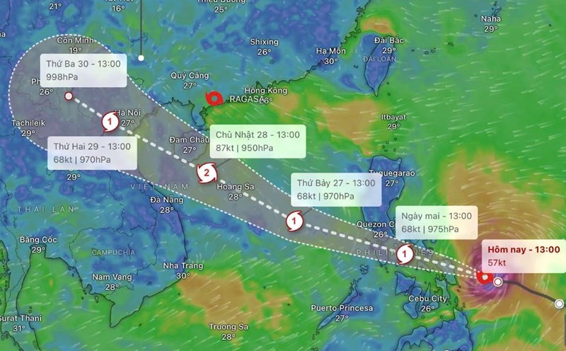
Meanwhile, according to the latest storm information from the Vietnam National Center for Hydro-Meteorological Forecasting, storm No. 10 moves very quickly (nearly double the average speed), is strong, has a wide range of influence, and can cause combined impacts such as strong winds, heavy rain, floods, flash floods, landslides and coastal flooding.
Forecast of storm developments (24-72 hours)
4:00 a.m. on September 28
Location: 16.3 degrees North latitude - 110.0 degrees East longitude, in the western sea of Hoang Sa province, about 180km east of Da Nang.
Movement: West Northwest, 30-35km/h, likely to strengthen. Intensity: Level 12-13, gust level 16.
Affected areas: North and Central East Sea (including Hoang Sa); sea area from Ha Tinh to Quang Ngai.
16:00 on September 28
Location: 17.4 degrees North latitude - 107.6 degrees East longitude, in the sea area from Ha Tinh - Thua Thien Hue, about 160km East Southeast of Bac Quang Tri.
Affected areas: the northwest sea of the East Sea (including Hoang Sa), the northwest of the central East Sea; from Thanh Hoa to Quang Ngai (hon Ngu, Con Co, Ly Son) and the northern Gulf of Tonkin (Bach Long Vy, Van Don, Co To, Cat Hai, Hon Dau); mainland from Ninh Binh to Thua Thien Hue.
4:00 a.m. on September 29
Location: 18.5 degrees North latitude - 105.5 degrees East longitude, on land from Nghe An to Bac Quang Tri.
Affected areas: The northwest sea area of the East Sea (including Hoang Sa), from Thanh Hoa to Quang Ngai (hon Ngu, Con Co, Ly Son), the northern Gulf of Tonkin (Bach Long Vy, Van Don, Co To, Cat Hai, Hon Dau); mainland from Ninh Binh to Thua Thien Hue.
4:00 a.m. on September 30
Location: 20.8 degrees North latitude - 101.1 degrees East longitude, in the Upper Laos region. Movement: West Northwest, 20-25km/h, weakening into a low pressure area.