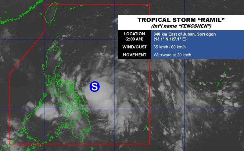
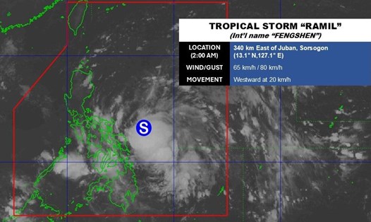
The latest storm news on the evening of October 18 from the Philippine Atmospheric, Geophysical and Astronomical Services Administration (PAGASA) said that Typhoon Fengshen is having sustained winds of 65 km/h near the center, gusts of up to 90 km/h. The winds in Typhoon Fengshen extend up to 400km from the center of the storm. The storm is currently moving slowly westward.
Philippine typhoon forecasters said Typhoon Fengshen will continue moving west-northwest across the mainland or coastal waters of the Bicol region until the morning of October 19. The storm will then approach or make landfall in the Polillo Islands on the morning of October 19 and make a final landfall in the vicinity of Aurora in the morning or afternoon of October 19.
The possibility of the latest typhoon in the Philippines making landfall in northern Quezon or southern Isabela instead of Aurora is also not ruled out.
According to the forecast track, after making landfall in Aurora, Typhoon Fengshen will pass through Northern Luzon and enter the East Sea, in the coastal waters of Pangasinan or La Union, Philippines, on the evening of October 19.
PAGASA said that Typhoon No. 12 will leave the Philippine forecast area on the morning of October 20. After entering the East Sea, the possibility of storm No. 12 continuing to strengthen is very high.
Many other weather agencies in the region are also issuing warnings about storm No. 12 in the East Sea.
Due to the influence of the northeast monsoon and Typhoon Fengshen, people in northern and eastern Taiwan (China) should be vigilant for potential disasters due to heavy rain starting from the night of October 18 to October 22. Heavy rain is forecast to hit the northern and northeastern mountainous areas of the island most severely, while residents in Hoa Lien and Dai Dong districts should also be vigilant, said independent meteorologist Wu Der-rong.
Typhoon Fengshen is moving northwest at a speed of 27 km/h towards Hainan Island, China and is not expected to directly affect Taiwan (China) - the CWA said in its latest typhoon report.
The Hong Kong (China) Weather Forecast Agency said it could issue a Category 3 storm warning on October 20 as Typhoon Fengshen moves closer to the coast of Guangdong, China. Typhoon No. 12 is forecast to be 800km from Hong Kong (China) on October 19 and closest approach Hong Kong (China) on October 21.
Tse Kwan-shu - a forecaster at the Hong Kong Meteorological Station (China) - noted that Hong Kong (China) will be affected by two consecutive weather systems: the monsoon affecting the southern coast of China on October 19 and storm No. 12 Fengshen. Due to this double effect, cloudy weather and rain will be recorded here until mid-week.
The latest storm news from the Thai Meteorological Department said that Typhoon No. 12 Fengshen is moving north of the East Sea and Hainan Island of China.
The storm's path announced by the Thai Meteorological Department shows that from October 18-19, Fengshen will pass through the northern regions of the Philippines before moving into the sea area above the East Sea.
From October 21-21, the storm will enter Hainan Island, China. Here, storm No. 12 is expected to weaken and dissipate rapidly.
Thai weather forecasters stress that Typhoon No. 12 will not directly affect Thailand, but the outer circulation of the storm is expected to bring heavy rain and strong winds across the southern part and the Gulf of Thailand.
Satellite images and radar taken on October 18 showed widespread thunderstorms covering the southeastern provinces of Thailand and the Gulf of Thailand, especially in the Chumphon and Surat Thani areas.