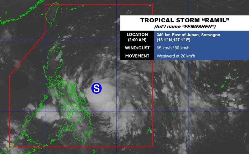
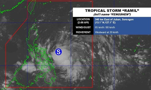
The latest storm information from the Philippine Atmospheric, Geophysical and Astronomical Services Administration (PAGASA) at noon on October 18 said that Typhoon Fengshen (called Ramil in the Philippines) is slowing down as it moves west-northwest over the sea east of Sorsogon, Philippines.
The center of the storm is 260 km east of Juban, Sorsogon. The storm is moving west-northwest at a speed of 15 km/h. Maintained winds of 65 km/h near the center of the storm and gusts of up to 80 km/h.
Philippine typhoon forecasters say that the 18th typhoon of the Philippines in 2025 will move mainly west-northwest, towards the Central - South Luzon area. According to the forecast track, the center of the storm could make landfall or pass near Catanduanes this afternoon or evening (18.18).
The storm will then continue moving west-northwest, passing near the islands of Vinzons, Camarines Norte and Polillo on the morning of October 19.
By the morning or afternoon of October 19, Typhoon Fengshen will turn northwest and may make landfall again in Aurora or Isabela. After making landfall, the storm will pass through the rugged terrain of Northern and Central Luzon and will enter the East Sea in the afternoon or evening of October 19.
During its operation in the South China Sea as Typhoon No. 12, Fengshen will leave the Philippines' forecast area on the morning of October 20.
Changing its path north or south could lead to the storm having another landfall area.
Before making landfall in the Philippines for the first time, Typhoon Fengshen is forecast to strengthen over the Philippine Sea. The possibility of strengthening into a severe tropical storm before making landfall cannot be ruled out.
After sweeping across the Philippine mainland, the storm may maintain its intensity or weaken slightly and is likely to strengthen further when it becomes the 12th storm in the East Sea.
The latest storm news from the Hong Kong Meteorological Station (China) said that Typhoon Fengshen will have maximum sustained winds of about 75 km/h, moving west at a speed of about 30 km/h on October 18. As it approaches the Luzon area of the Philippines, the storm is likely to intensify.
By the morning of October 19, the storm will become a severe tropical storm with winds of 90 km/h, making landfall in central Luzon before continuing to move northwest across the island and into the East Sea.
Forecasting the path of Typhoon No. 12 in the East Sea, typhoon forecasters from the Hong Kong Meteorological Station (China) said that the typhoon will be about 800km southeast of Hong Kong (China) by the evening of October 19. The storm will continue to move northwest and strengthen.
By the morning of October 20, Typhoon Fengshen could be about 500km from Hong Kong (China) and by the morning of October 21 about 400km from Hong Kong (China), reaching typhoon strength, with maximum sustained winds of up to 120km/h.
However, the strong northeast monsoon from the south is expected to create a strong 90-degree turn, shifting storm No. 12 southwest and weakening the storm, potentially returning to tropical storm status on the morning of October 22.
Hong Kong (China) weather forecasters note that the time and location of this turning point are still uncertain. The approach of Typhoon No. 12 will bring significant changes in the weather for Hong Kong (China).