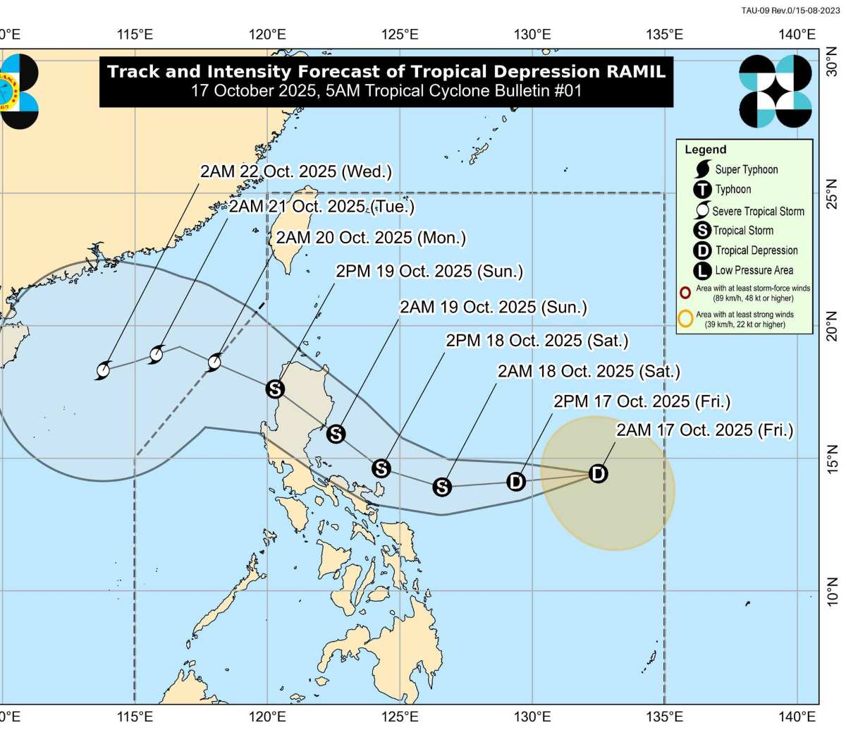
The latest storm information from the Philippine Atmospheric, Geophysical and Astronomical Services Administration (PAGASA) said that the low pressure area that the agency has been monitoring for many days has strengthened into a tropical depression at 2:00 a.m. on October 17, after entering the Philippine Forecast Area (PAR) at noon on October 16. The system is named Ramil, the 18th tropical cyclone of the Philippines in 2025.
At 4:00 a.m. on October 17, the center of tropical depression Ramil was located about 1,145 km southeast of Luzon, moving slowly in a west-northwest direction, with maximum sustained winds of 45 km/h, gusting to 55 km/h.
According to PAGASA, Ramil may approach Catanduanes in the morning or afternoon of October 18, then make landfall in the Aurora or Quezon areas on October 19. However, the agency warned that if the epidemic trajectory goes south, the landfall area could change.
Ramil is forecast to strengthen into a tropical storm on the morning of October 18, and the possibility of reaching strong typhoon status (violent tropical storm) before approaching the Luzon mainland is not ruled out. If it passes the Philippines and enters the East Sea, it will be the 12th storm of the year in the region.
If the storm follows PAGASA's forecast and crosses Luzon Island, the system could enter the South China Sea as early as October 19, becoming the 12th storm, expected to directly affect Central and Northern Vietnam in the last days of October.
However, the path and affected area of the storm are still uncertain, as it may be affected by the cold air mass moving from the north to Vietnam.
According to the Vietnam National Center for Hydro-Meteorological Forecasting, on the day and night of October 17, the following sea areas will have scattered showers and thunderstorms: The sea area from Quang Tri to Ca Mau; the sea area from Ca Mau to An Giang; the Gulf of Thailand; the South East Sea area (including Truong Sa special zone).
During thunderstorms, there is a possibility of tornadoes, strong gusts of wind of level 6-7, waves over 2m high.
Regarding today's weather forecast:
Hanoi
Lowest temperature: 23-25 degrees Celsius Highest temperature: 31-33 degrees Celsius Cloudy, sunny during the day, showers and thunderstorms in some places in the evening and at night.
Light wind
Northwest
Lowest temperature: 21-24 degrees Celsius, some places below 21 degrees Celsius Highest temperature: 29-32 degrees Celsius, some places above 32 degrees Celsius Cloudy, sunny during the day, showers and thunderstorms in some places in the evening and at night.
Light wind
Northeast
Lowest temperature: 22-25 degrees Celsius, mountainous areas below 22 degrees Celsius Highest temperature: 30-33 degrees Celsius Cloudy, sunny during the day, showers and thunderstorms in some places in the evening and at night.
Light wind
Thanh Hoa to Hue
Lowest temperature: 23-26 degrees Celsius Highest temperature: 28-31 degrees Celsius The North is cloudy, with scattered showers and thunderstorms, locally heavy rain (rain concentrated in the afternoon and night); the South is cloudy, with moderate rain, heavy rain and thunderstorms, locally very heavy rain.
Light wind.During thunderstorms, there is a possibility of tornadoes, lightning and strong gusts of wind.
Ho Chi Minh City
Lowest temperature: 24-26 degrees Celsius Highest temperature: 30-32 degrees Celsius Cloudy, scattered showers and thunderstorms in some places; In the afternoon and evening, there will be scattered showers and thunderstorms, locally heavy rain in some places.
Light wind.During thunderstorms, there is a possibility of tornadoes, lightning and strong gusts of wind.