Storm No. 13 Kalmaegi devastates the Philippines, forecast to make landfall in Vietnam

Song Minh |

After devastating the Philippines, killing at least 46 people, storm No. 13 Kalaegi has entered the East Sea, about to make landfall in Vietnam.

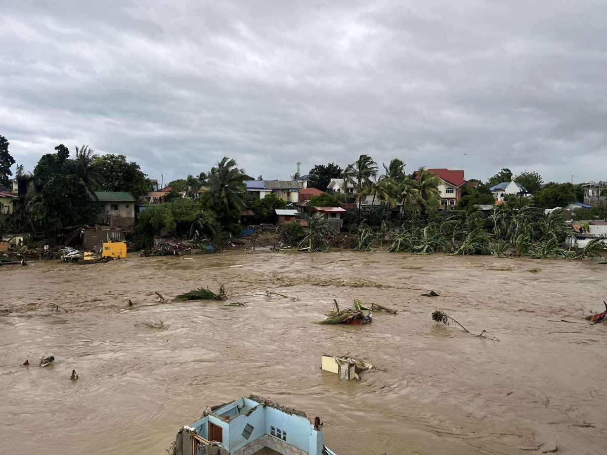
The Philippines is struggling to cope with the consequences of Typhoon No. 13 Kalmaegi (local name Tino) with terrible showers and flash floods over a wide area.

At least 46 people have died due to flooding in the central region of the country, hundreds of homes were swept away or deeply submerged in mud, and many arterial roads were cut off.

Data from the Japan Aerospace Research Agency (JAXA) shows that rainfall in the central Philippines over the past 3 days has exceeded 610mm - equivalent to the average rainfall for the whole month of November. Strong winds, high waves and high tides have completely isolated many coastal areas.

Lu lon sau bao so 13 tan pha nhieu ngoi nha tai Sitio Isla Verde, Barangay San Isidro, thanh pho Talisay, tinh Cebu. Anh: Philippine Weather System/Pacific Storm Update
Heavy flooding after storm No. 13 devastated Barangay San Isidro, Talisay, province of concubines. Photo: Philippine Weather System/Pacific Storm Update

While the Philippines is still overcoming the consequences, the meteorological world warns that another storm is forming in the eastern Pacific. The tropical depression passing south of Guam is forecast to strengthen into Typhoon Fung-wong (Uwan) in the middle of this week.

The new typhoon is expected to move west-northwest, likely reaching strong intensity before approaching the northern Philippines or Taiwan (China) early next week.

Natural disasters have hit the Southeast Asian island nation in a matter of weeks after a 7.4-magnitude earthquake rocked the southern Philippines.

Meanwhile, according to the latest storm information from the Vietnam National Center for Hydro-Meteorological Forecasting, early this morning (November 5), storm Kalmaegi entered the eastern sea area of the central East Sea, becoming the 13th storm in the East Sea in 2025.

Du bao duong di va vung do bo Viet Nam cua bao so 13. Anh: Trung tam Du bao Khi tuong Thuy van Quoc gia Viet Nam
Forecast of the path and landing area of storm No. 13 in Vietnam. Photo: Vietnam National Center for Hydro-Meteorological Forecasting

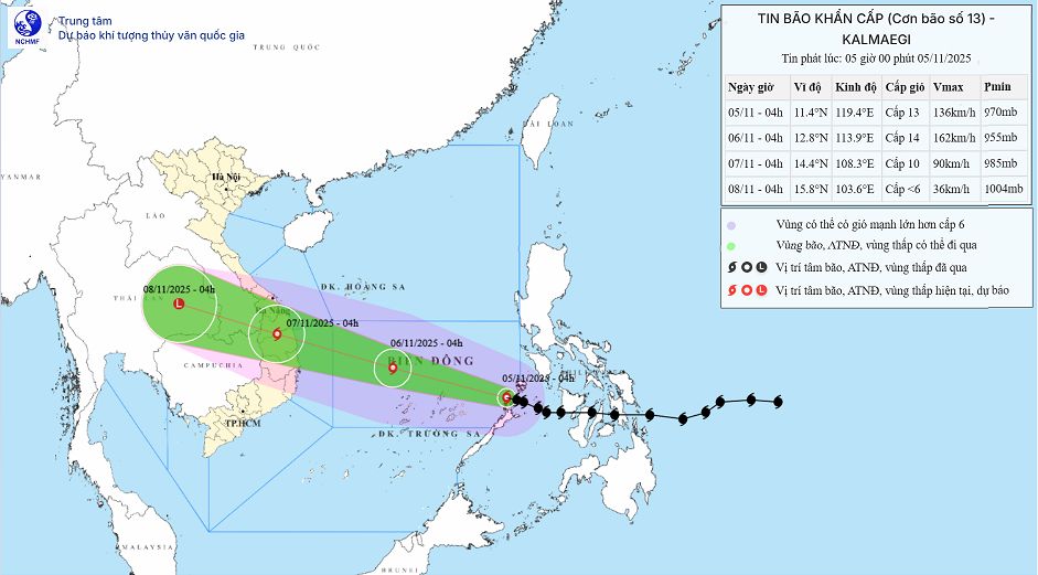
At 6:00 a.m. on November 5, the center of the storm was at about 11.4 degrees north latitude; 119.0 degrees east longitude, about 510km east of Song Tu Tay Island. The strongest wind is level 13 (134-149 km/h), gusting to level 16. It is forecasted that in the next 3 hours, the storm will move west-northwest, at a speed of about 20-25 km/h.

It is forecasted that by 4:00 a.m. on November 6, the center of the storm will be at 12.8 degrees north latitude, 113.9 degrees east longitude; about 550km east-southeast of the Gia Lai province coast. The storm is likely to strengthen, reaching level 14, gusting to level 17, moving west-northwest, about 25km/h.

It is forecasted that by 4:00 a.m. on November 7, the center of the storm will be at 14.4 degrees north latitude, 108.3 degrees east longitude, on the mainland from Quang Ngai to Dak Lak. The storm will gradually weaken, become stronger at level 9-10, gusting to level 12, moving west-northwest, about 25 km/h.

The center of storm No. 13 is forecast to enter the northern area of Phu Yen and southern Quang Ngai, but may change. Forecast time for the center of the storm to make landfall around the evening of November 6 and the morning of November 7. However, the center of the rain is before the storm, so there will be heavy rain from noon on November 6.

Rain forecast from November 6-7: The area from Da Nang City to Dak Lak will have very heavy rain with common rainfall of 200-400 mm/ods, locally over 600 mm/ods; the area from southern Quang Tri to Hue City, Khanh Hoa and Lam Dong will have heavy rain with common rainfall of 150-300 mm/ods, locally very heavy rain over 450 mm/ods. From November 8, heavy rain in the above areas tends to decrease.

From November 7-8, the northern area from Quang Tri to Thanh Hoa will have moderate rain, heavy rain with common rainfall of 50-150 mm/ods, locally very heavy rain over 200 mm/ods. Warning of the risk of heavy rain (>200 mm/3 hours).

Song Minh
RELATED NEWS

The predecessor of storm No. 13 weakens, unpredictable developments are forecast when entering the East Sea

|

Typhoon Kalmaegi - the predecessor of Typhoon No. 13 - is moving slowly and weakening but is forecast to still have the potential to intensify when it enters the East Sea on November 5.

Low pressure forecast after storm No. 13 Kalmaegi may reach super typhoon level

|

The low pressure area after storm No. 13 Kalmaegi in the eastern Philippines is forecast to strengthen into a strong storm, not excluding the possibility of becoming a super typhoon.

Forecast of the possibility of storm No. 13 suddenly intensifying before making landfall

|

It is not ruled out that Typhoon Kalmaegi - the predecessor of Typhoon No. 13 - will suddenly accelerate before making landfall, when the storm is at or near its peak intensity.

German court tries Vingroup case against Le Trung Khoa

|

On November 4, a court in Berlin, Germany held a trial of the Vingroup/VinFast case against Le Trung Khoa for defamation and slander.

Gia Lai market caught fire at night, 86 kiosks burned

|

Gia Lai - The authorities are investigating the cause of the fire at 86 kiosks at Binh Duong market that occurred overnight, causing damage to many properties.

AFC expresses view after Malaysia's failed appeal

|

The Asian Football Confederation affirmed that it will not interfere in FIFA's dismissal of Malaysia's appeal and wait for the verdict from the Court of Arbitration for Sport.

President Putin requests to build a strategy for Russia's rare earths

|

President Vladimir Putin has just asked the Russian government to build a long-term strategy for the rare earth metal mining and production industry.

Plane crash in the US, smoke and fire cover, many injured

|

The US plane crash that occurred on November 4 (local time) in the state of Kentucky left many people injured.

The predecessor of storm No. 13 weakens, unpredictable developments are forecast when entering the East Sea

Song Minh |

Typhoon Kalmaegi - the predecessor of Typhoon No. 13 - is moving slowly and weakening but is forecast to still have the potential to intensify when it enters the East Sea on November 5.

Low pressure forecast after storm No. 13 Kalmaegi may reach super typhoon level

Song Minh |

The low pressure area after storm No. 13 Kalmaegi in the eastern Philippines is forecast to strengthen into a strong storm, not excluding the possibility of becoming a super typhoon.

Forecast of the possibility of storm No. 13 suddenly intensifying before making landfall

Khánh Minh |

It is not ruled out that Typhoon Kalmaegi - the predecessor of Typhoon No. 13 - will suddenly accelerate before making landfall, when the storm is at or near its peak intensity.