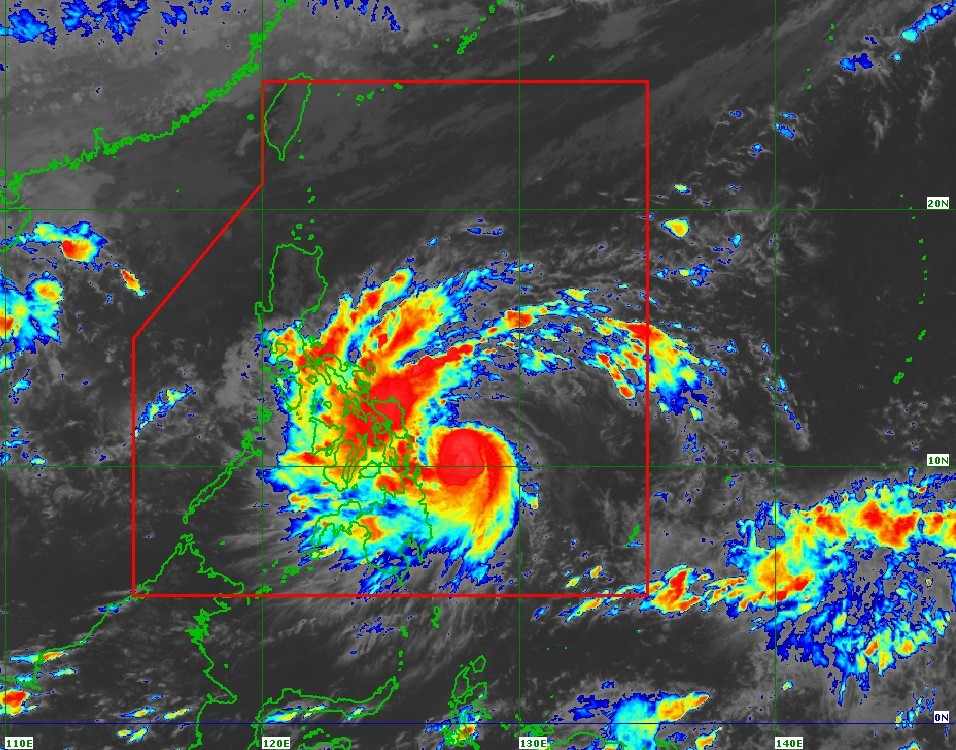
On the afternoon of November 3, typhoon Kalmaegi (local name Tino) maintained its strength as it moved straight into the sea east of the Philippines, carrying level 15 gusts and widespread heavy rain, causing many places in the central Philippines to begin to be deeply submerged in water.
The latest storm information from the Philippine Atmospheric, Geophysical and Astronomical Services Administration (PAGASA) said that at 2:00 p.m. on November 3, the center of typhoon Kalmaegi was located 215km from Guiuan, Eastern Samar, with maximum sustained winds of 130 km/h, gusts of 160 km/h, central pressure of 975 hPa and moving west at a speed of 25 km/h.
The strong wind radius extends up to 300km from the center of the storm, covering many areas of the central Philippines. PAGASA warned that extremely heavy rains, strong winds and dangerous rising water could occur not only in the area where the storm made landfall but also in neighboring areas, as the storm's path is still likely to shift within the forecast range.
In the next 24 hours, the storm is expected to sweep across the southern provinces of Eastern Samar, Leyte, Southern Leyte or Dinagat Island tonight or early tomorrow morning, November 4. The storm will then pass through the Visayas and northern Palawan, before moving into the South China Sea on the afternoon of November 5. It is forecasted that by the morning of November 6, the storm will continue to be strong and may continue to increase in intensity in the East Sea.
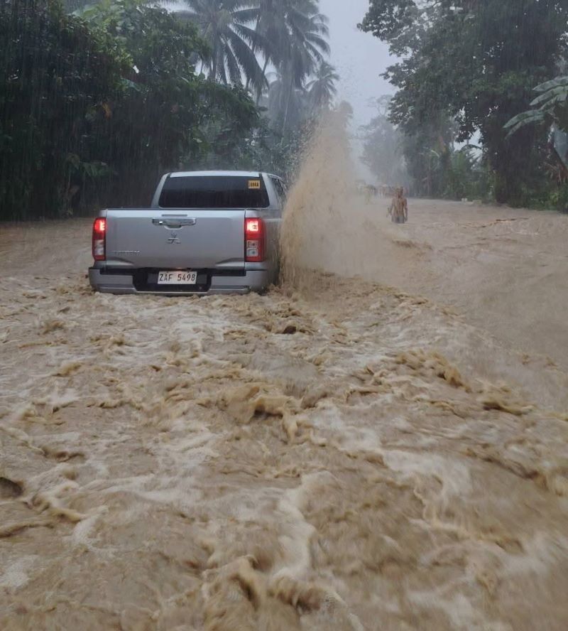
In Cagayan de Oro City, authorities have given civil servants a day off from work from the afternoon of November 3 to 4 to ensure safety, after prolonged heavy rains flooded many roads. Dozens of areas in Agusan del Norte province also recorded rapid flooding, especially in Barangay Concepcion ( Cabadbaran city), where floodwaters have overflowed people's houses.
The Civil Aviation Authority of the Philippines (CAAP) announced that about 30 flights had been canceled as of noon on November 3.
The Philippine Power Department said that some areas in the Central region have suffered widespread power outages, and technical forces are on duty to restore power soon after the weather conditions allow.
It is forecasted that when entering the East Sea, storm No. 13 will strengthen again after weakening due to contact with many islands in the Philippines. The strongest intensity in the East Sea may range from level 13-15, gusting to level 15-17, the storm axis will head towards the mainland of Central Vietnam on November 7, which was heavily damaged by previous historic floods.
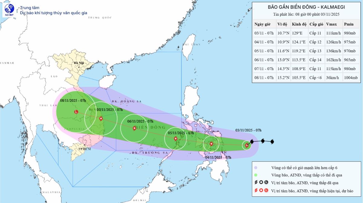
The vast majority of international storm forecast models have issued bad forecasts for storm No. 13 as it prepares to make landfall in Vietnam, with the most dangerous area being from Binh Dinh to Da Nang - Hue.
The Vietnam National Center for Hydro-Meteorological Forecasting forecasts that storm No. 13 will be strong at level 14, gusting to level 17 at 1:00 p.m. on November 6 when the storm is about 340km southeast of the Gia Lai province coast.
The Japan Meteorological Agency (JMA) forecasts maximum sustained winds near the center of the storm at 148 km/h, gusting to 210 km/h (level 17.0 gust), while still about 50 km from the coast of Binh Dinh at around 9am on November 7.
The US Joint Typhoon Warning Center (JTWC) forecasts the strongest wind speed at 194 km/h, gusting to 240 km/h ( gusting above level 17) when it was about 100 km from the coast of Binh Dinh - Quang Ngai at around 7am on November 7.
It is not excluded that storm No. 13 may still shift south to Khanh Hoa - Phu Yen, with rainfall of over 500mm within 24 hours from Khanh Hoa to Hue from about November 6-8.


