The predecessor of storm No. 13 weakens, unpredictable developments are forecast when entering the East Sea

Song Minh |

Typhoon Kalmaegi - the predecessor of Typhoon No. 13 - is moving slowly and weakening but is forecast to still have the potential to intensify when it enters the East Sea on November 5.

The latest storm information from the Philippine Atmospheric, Geophysical and Astronomical Services Administration (PAGASA) said that at 1:00 p.m. on November 4, the center of storm Kalmaegi (local name: Tino) was at 10.6 degrees north latitude; 122.5 degrees east longitude, in the sea off Jordan, Guimaras province, Philippines.

Maximum winds near the center of the storm are 130 km/h, gusting up to 180 km/h, central pressure 970 hPa. The storm is moving west-southwest at a speed of 20 km/h, causing strong winds and heavy rain over a wide area in the central Philippines.

The range of strong storm winds extends up to 300km from the center, seriously affecting the island area of Guimaras, the provinces of Antique, Iloilo, Aklan, Capiz and part of Negros.

PAGASA is currently maintaining a level 4 storm warning for many localities, warning of strong winds of 118-184 km/h, seriously threatening life and property.

Lu lon sau bao cuon troi nhieu nha dan o Sitio Isla Verde, Barangay San Isidro, thanh pho Talisay, tinh Cebu, Philippines, sang 4.11. Anh: Philippine Weather System/Pacific Storm Update
Heavy floods after the storm swept away many houses in Sitio Isla Verde, Barangay San Isidro, Talisay City, Philippines province, on the morning of November 4. Photo: Philippine Weather System/Pacific Storm Update

Neighborhoods such as the Cuyo Islands, northern Palawan, Negros Occidental and Cebu are also in the level 2-3 warning area, where strong winds could reach 90-120 km/h with heavy rain and the risk of landslides.

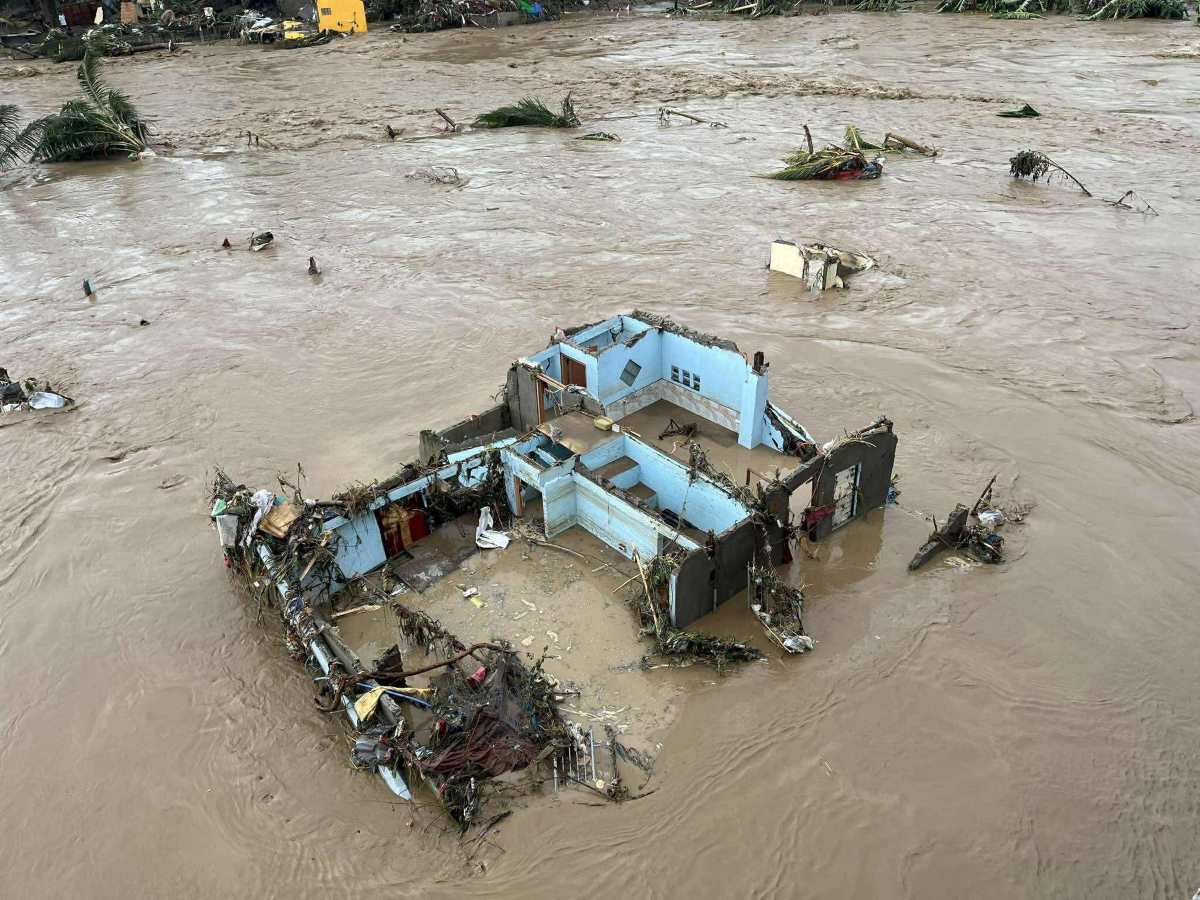
Due to the simultaneous influence of the strengthening and low-pressure northeast monsoon, many coastal areas such as Romblon, Mindoro, Palawan and Western Visayas are at risk of being affected by waves 3-6m high and storm surge exceeding 3m. Rescue agencies have warned people in low-lying coastal areas to evacuate urgently due to the risk of deep flooding and sudden high waves.

PAGASA said all maritime activities are dangerous, requiring ships to anchor at ports safely or avoid going to sea until the sea is calm again.

It is forecasted that in the next 24 hours, storm Kalmaegi will continue to weaken as it moves through the Western Visayas, then out into the Sulu Sea and enter the East Sea on November 5, becoming storm No. 13.

When entering the East Sea, the storm will move rapidly west and west-northwest at a speed of 25 km/h, the possibility of the storm will strengthen, forming an extremely large eye and a very strong convection of storm clouds around the eye, the maximum intensity in the East Sea can reach level 14-15, gusting above level 17.

The Vietnam Center for Hydro-Meteorological Forecasting also said that at 1:00 p.m. on November 6, the center of storm No. 13 was at 13.1 degrees north latitude; 111.9 degrees east longitude; in the central East Sea, about 320km east-southeast of the Gia Lai province coast. The storm is likely to strengthen, reaching level 14, gusting to level 17. Moving west-northwest, about 25 km/h.

Du bao duong di cua bao Kalmaegi. Anh: Trung tam Du bao Khi tuong Thuy van Quoc gia Viet Nam
Forecast track of Typhoon Kalmaegi. Photo: Vietnam National Center for Hydro-Meteorological Forecasting

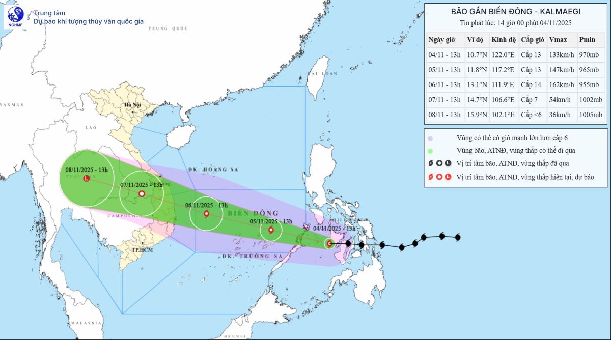
At 1:00 p.m. on November 7, the storm is forecast to be at 14.7 degrees north latitude; 106.6 degrees east longitude, in the Southern Laos area. The storm gradually weakened into a tropical depression, strong at level 7, gusting to level 8.

Regarding rain forecasts, the area affected by heavy rain and strong winds of storm No. 13 is expected to be from Hue - Khanh Hoa, focusing on Quang Nam (old) - Quang Ngai - Binh Dinh - Phu Yen, the heavy rain will expand to the entire Quang Tri - North Central region, even the Northern Delta on November 8-9.

Song Minh
RELATED NEWS

Low pressure forecast after storm No. 13 Kalmaegi may reach super typhoon level

|

The low pressure area after storm No. 13 Kalmaegi in the eastern Philippines is forecast to strengthen into a strong storm, not excluding the possibility of becoming a super typhoon.

Typhoon No. 13 Kalmaegi devastates the Philippines, reminiscent of super typhoon Hai Yen 2013

|

Typhoon Kalmaegi - storm No. 13 - made landfall in the central Philippines last night, evoking the horrifying memories of super typhoon Haiyan in 2013.

Forecast of the possibility of storm No. 13 suddenly intensifying before making landfall

|

It is not ruled out that Typhoon Kalmaegi - the predecessor of Typhoon No. 13 - will suddenly accelerate before making landfall, when the storm is at or near its peak intensity.

20h News: The highest personal income tax rate is expected to be 35%

|

20h News on November 4: The highest personal income tax rate is expected to be 35%; Son Hai Group speaks out after the information about the project inspection conclusion;...

Penalty for the case of a brother-in-law who caused a series of accidents in Thai Nguyen

|

Thai Nguyen - Without steering, a young man still stood up to take over his brother-in-law after he caused an accident and was fined 2.5 million VND.

Tea room fire at the foot of An Duong bridge, Hai Phong

|

Hai Phong - On November 4, there were 2 fires in houses in Le Chan ward and An Hai ward in the city.

Continued landslides in Ha Tinh while workers are crossing the route, 2 people injured

|

Ha Tinh - A worker driving a excavator and a truck driver while clearing rocks and soil to clear the route continued to slide, causing both the vehicle and the engine to collapse, injuring 2 people.

There will soon be regulations for foreign investors to place orders through global securities brokerage companies

|

A representative of the State Securities Commission said that many policies are being built to raise market standards, expand products and attract investors.

Low pressure forecast after storm No. 13 Kalmaegi may reach super typhoon level

Song Minh |

The low pressure area after storm No. 13 Kalmaegi in the eastern Philippines is forecast to strengthen into a strong storm, not excluding the possibility of becoming a super typhoon.

Typhoon No. 13 Kalmaegi devastates the Philippines, reminiscent of super typhoon Hai Yen 2013

Khánh Minh |

Typhoon Kalmaegi - storm No. 13 - made landfall in the central Philippines last night, evoking the horrifying memories of super typhoon Haiyan in 2013.

Forecast of the possibility of storm No. 13 suddenly intensifying before making landfall

Khánh Minh |

It is not ruled out that Typhoon Kalmaegi - the predecessor of Typhoon No. 13 - will suddenly accelerate before making landfall, when the storm is at or near its peak intensity.