According to the latest storm information at 9:00 a.m. on November 4 from the Japan Meteorological Agency (JMA), the low pressure area located east of Mindanao, outside the Philippine Forecast Area (PAR) officially became a tropical depression on the morning of November 4.
According to forecast models, the tropical depression will move west-northwest as it passes through the Philippine Sea in the coming days.
According to GFS's storm forecast model, the tropical depression will rapidly strengthen over the next 48-72 hours, possibly reaching typhoon or super typhoon strength before making landfall.
Meanwhile, the ECMWF model predicts weaker intensity, but a similar trend suggests a storm could strengthen as it approaches land.
The tropical depression/storm is expected to enter PAR between Thursday evening and Friday morning (November 6-7, 2025). When it enters PAR, PAGASA will name it Typhoon Rain.
As the tropical depression is likely to strengthen, Luzon residents, especially in Northern and Central Luzon, should prepare and focus on possible further scenarios.
Forecast of the direction and intensity of tropical depressions/storm rain in the coming days may change depending on atmospheric conditions such as high pressure area intensity, wind shear and sea water temperature.
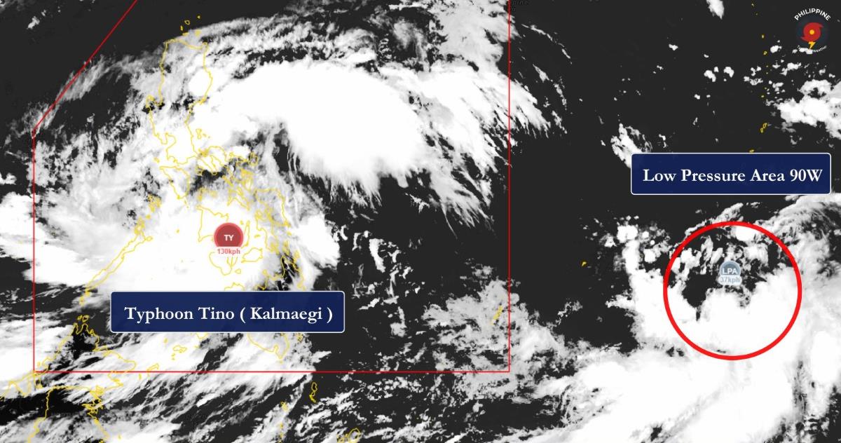
Meanwhile, storm Tino (international name Kalmaegi - the predecessor of storm No. 13 in the East Sea) made its second landfall at around 5:10 a.m. on November 4 in Borbon, Philippines. The storm made its first landfall in Silago, Southern Leyte, shortly after midnight.
At 7:00 a.m. on November 4, the center of the storm was at about 10.7 degrees north latitude; 123.5 degrees east longitude, in the central Philippines. The strongest wind near the storm center is level 13 (134-149 km/h), gusting to 205 km/h (level 16). The storm is moving west-northwest at a speed of about 20 km/h.
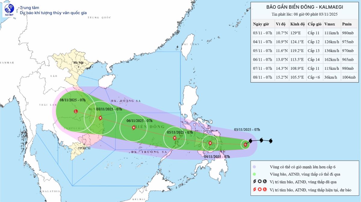
According to the Vietnam National Center for Hydro-Meteorological Forecasting, at 7:00 a.m. on November 5, the storm was at about 11.5 degrees north latitude; 118.7 degrees east longitude; in the sea east of the central East Sea. Storm intensity level 13, gusts level 16, moving into the East Sea, west-northwest, speed 20-25 km/h.
At 7:00 a.m. on November 6, the center of the storm was at 12.8 degrees north latitude; 113.4 degrees east longitude; in the central East Sea, about 500km east-southeast of the Gia Lai province coast. The storm is likely to strengthen, reaching level 14, gusting to level 17, moving west-northwest, about 25 km/h.
At 7:00 a.m. on November 7, the center of the storm was at 14.4 degrees north latitude; 108.0 degrees east longitude; in the mainland provinces from Quang Ngai to Dak Lak. The storm will gradually weaken, become stronger at level 10-11, gusting to level 13, moving west-northwest, about 25 km/h.


