The predecessor of storm No. 13 Kalmaegi opens its eyes, preparing to explode in strength

Song Minh |

The eye of Typhoon Kalmaegi - the predecessor of Typhoon No. 13 - has begun to "open", signaling that the power could explode in the next few hours.

The latest storm information from the Philippine Atmospheric, Geophysical and Astronomical Services Administration (PAGASA) said that at 4:00 a.m. on November 3, the center of typhoon Kalmaegi (local name: Tino) was about 430 km east of Guiuan, Eastern Samar province, moving west-southwest at a speed of 30 km/h.

The strongest wind near the center of the storm reached 110 km/h, gusting to 135 km/h; central pressure 980 hPa. The storm-force wind radius will expand to 300km.

It is forecasted that in the next 12 hours, storm Kalmaegi will continue to strengthen and may reach strong storm or super typhoon level, with expected winds of 150-165 km/h, and may even reach 185 km/h if the rapid intensification process is complete.

The conditions at sea in the Philippines are currently very favorable: High sea surface temperatures and weak wind shear - two ideal factors for storms to "increase".

If it does not change direction, Typhoon Kalmaegi is expected to make landfall in Eastern Samar, Leyte or Dinagat Island at midnight on November 3 or early tomorrow morning (November 4), then sweep across the Visayas and north of Palawan, then out into the East Sea on November 5, becoming Typhoon No. 13.

The intensification of storm Kalmaegi. Video: Zoom Earth

The coastal areas of Eastern Visayas, Bicol and northern Mindanao will experience heavy to very heavy rains, with the risk of flash floods and landslides in mountainous areas.

Strong winds will also spread across the central Philippines, affecting southern Luzon.

Sea level rise from 5 to 9 meters along the east coasts of Samar, Leyte and Siargao Island, endangering all types of vessels.

PAGASA warns that all sea travel activities are extremely risky, especially for small boats and fishing boats. Ship at sea need to quickly find a safe shelter.

The US Joint Typhoon Warning Center (JTWC) also confirmed that Typhoon Kalmaegi is "entering a rapid intensification phase", as the convective cloud structure around the center begins to close, forming a clear eye of the storm on satellite imagery. This means that the storm is reaching high stability and the wind will increase rapidly in the next few hours.

The Philippine Meteorological Department stressed that although Kalmaegi may weaken slightly when it makes landfall, the storm will remain strong throughout its journey through the country, before entering the East Sea.

The storm forecast bulletin at 2:00 a.m. on November 3 of the Vietnam National Center for Hydro-Meteorological Forecasting said that due to the influence of storm Kalmaegi, from around the afternoon of November 4, the sea area east of the central East Sea will have winds gradually increasing to level 6-7, then increasing to level 8-9; the area near the storm center will be strong at level 10-12, gusts of level 14-15, waves 5.0-7.0m high. The sea is rough.

Du bao duong di cua bao Kalmaegi. Anh: Trung tam Du bao Khi tuong Thuy van Quoc gia Viet Nam
Forecast track of Typhoon Kalmaegi. Photo: Vietnam National Center for Hydro-Meteorological Forecasting

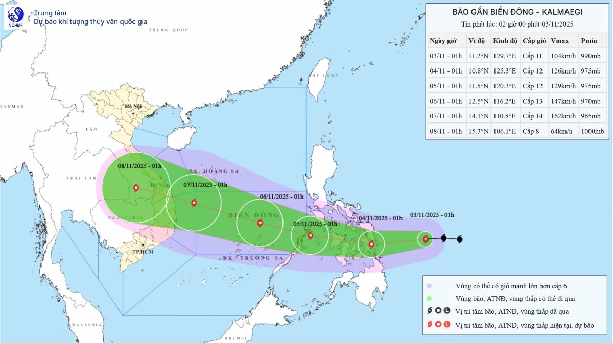
Warning: Around November 5-6, the central East Sea area (including Truong Sa special zone), the sea area off the coast of Da Nang - Khanh Hoa area is likely to be affected by strong winds of level 12-14, gusting above level 17, waves 8.0-10.0m high. The sea is rough.

All ships and works operating in the above-mentioned danger zone were greatly affected by thunderstorms, whirlwinds, strong winds, and large waves.

Song Minh
RELATED NEWS

Storm No. 13 Kalmaegi warning is similar to super typhoon Hai Yen 2013

|

Typhoon Kalmaegi, the predecessor to Typhoon No. 13 in the East Sea, does not rule out the possibility of reaching super typhoon level, with a similar trajectory to Typhoon Haiyan in 2013.

Storm No. 13 has the potential to strengthen rapidly, forecasting the first landfall area

|

Typhoon Kalmaegi - the predecessor of Typhoon No. 13 in the East Sea - is forecast to make landfall with gusts of over 150 km/h and widespread heavy rain.

Forecast of the possibility of storm No. 13 suddenly intensifying before making landfall

|

It is not ruled out that Typhoon Kalmaegi - the predecessor of Typhoon No. 13 - will suddenly accelerate before making landfall, when the storm is at or near its peak intensity.

International beauties, used cars add sparkling beauty to Da Lat streets

|

Da Lat - Da Lat City of Thousands of Flowers is more sparkling with the participation of nearly 80 international beauties and dozens of ancient cars participating in the parade through the streets.

Electricity says Ecohome Nhon Binh lacks cooperation in power generation

|

Gia Lai - Regarding the prolonged power outage at Ecohome Nhon Binh Social Housing Apartment, the Electricity sector said it has provided full support but the repair process is still very slow.

Thien Khoi FC crowned champion of the 2025 National 7-a-side Football Cup

|

Defeating Dai Tu in a dramatic final match, Thien Khoi FC became the champion of the 2025 Hyundai Thanh Cong Cup National 7-a-side Football Cup (VSC-S5).

Traffic ban on Prenn Pass to Da Lat from tomorrow afternoon, December 8

|

Lam Dong - The ban on traffic on Prenn Pass will take place from 11am to 5pm on December 8 to cut down trees at risk of falling, causing traffic insecurity.

Gia Bac Pass in Lam Dong opens to traffic after 5 days of paralysis due to serious landslides

|

Lam Dong - At 5:00 p.m. this afternoon, Gia Bac Pass officially opened the route, vehicles on National Highway 28 began traveling again after a period of paralysis due to landslides.

Storm No. 13 Kalmaegi warning is similar to super typhoon Hai Yen 2013

Song Minh |

Typhoon Kalmaegi, the predecessor to Typhoon No. 13 in the East Sea, does not rule out the possibility of reaching super typhoon level, with a similar trajectory to Typhoon Haiyan in 2013.

Storm No. 13 has the potential to strengthen rapidly, forecasting the first landfall area

Song Minh |

Typhoon Kalmaegi - the predecessor of Typhoon No. 13 in the East Sea - is forecast to make landfall with gusts of over 150 km/h and widespread heavy rain.

Forecast of the possibility of storm No. 13 suddenly intensifying before making landfall

Khánh Minh |

It is not ruled out that Typhoon Kalmaegi - the predecessor of Typhoon No. 13 - will suddenly accelerate before making landfall, when the storm is at or near its peak intensity.