The latest typhoon bulletin from the Philippine Atmospheric, Geophysical and Astronomical Services Administration (PAGASA) said that at least one to two tropical storms may make landfall in the Philippine forecast area (PAR) in November.
PAGASA weather forecaster Benison Estareja said based on records going back to 1948, tropical storms used to make landfall in November.
Tropical storms near the Philippines this month also have the potential to reach typhoon or even super typhoon strength, Estareja noted.
"Tropical storms typically make landfall every November in Luzon, Visayas and until recently in the Caraga Region. The chances of changing course or returning to the Philippine Sea are getting smaller," said Estareja.
"For November, in terms of intensity, we can still have typhoons and super typhoons. And especially in November this year, one to two tropical storms could enter the Philippine PAR," added typhoon forecaster Estareja.
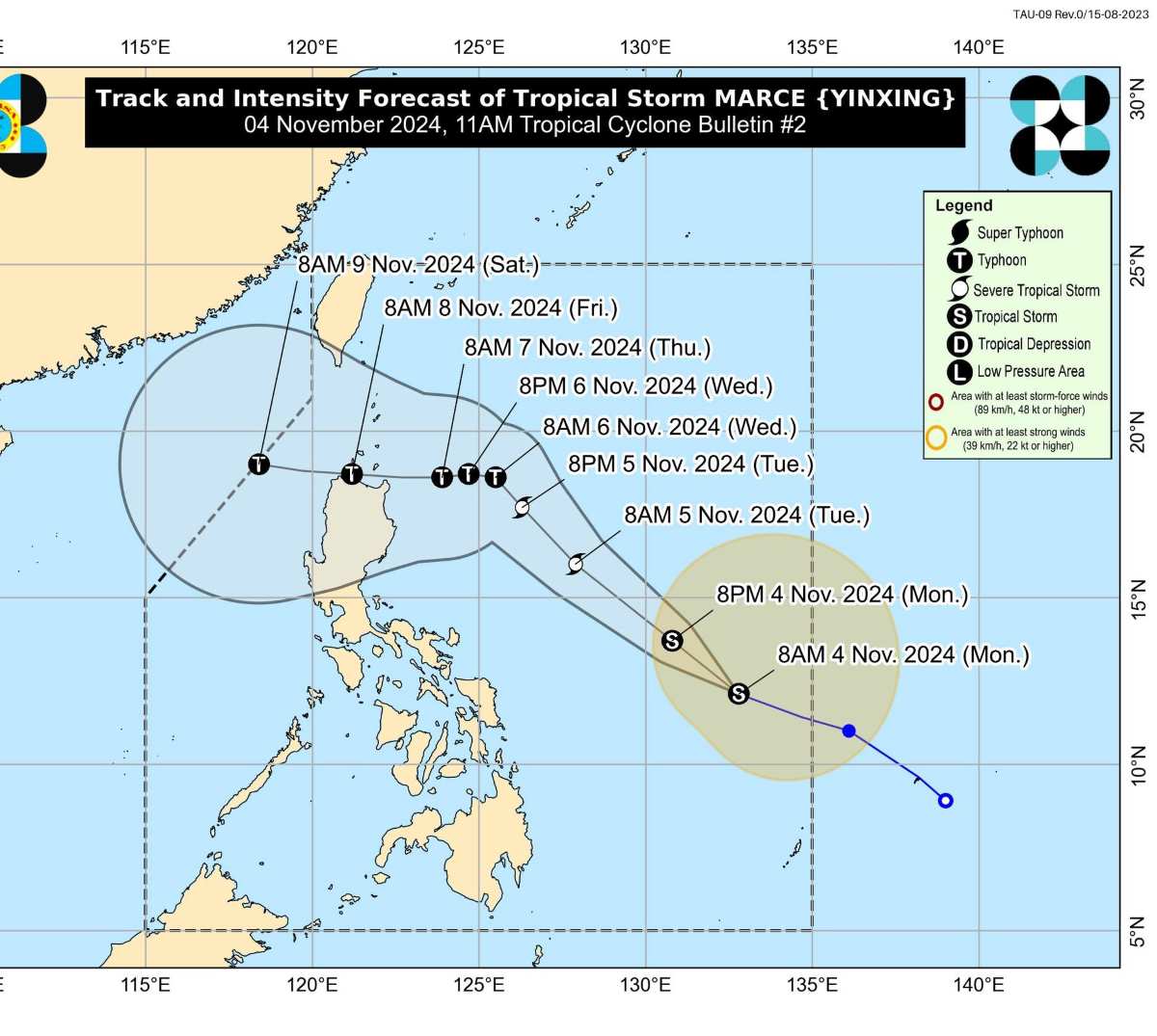
According to the latest storm news on November 4 from PAGASA, storm Marce (international name Yinxing) is strengthening as it moves west-northwest over the Philippine Sea.

At 10:00 a.m. on November 4, the center of tropical storm Marce was at approximately 12.4 degrees north latitude, 132.5 degrees east longitude, 775 km east of Borongan City, Eastern Samar.
The strongest winds near the storm center reached 75 km/h, gusting up to 90 km/h and the central pressure was 998 hPa. The storm moved west-northwest at 35 km/h. Hurricane-force winds covered 580 km from the storm center.
Typhoon Marce is forecast to move mainly west-northwest until November 5 before turning west at a slow speed over the Philippine Sea, east of Northern Luzon.
According to the forecast track, Typhoon Marce will make landfall in the vicinity of Babuyan Islands or the northern mainland of Cagayan late Thursday (November 7) or early Friday (November 8).
Due to uncertainty over the intensity of the high pressure area north of Typhoon Marce, the storm's track could still change and bring it to landfall in the Cagayan-Isabela region.
The tropical storm is expected to gradually strengthen and could reach severe tropical storm status by November 5. It could also reach typhoon status by the evening of November 5 or early morning of November 6.
Meanwhile, the European Centre for Medium-Range Weather Forecasts (ECMWF) said that Typhoon Yinxing could enter the central area of the northern East Sea this week.
The Japan Meteorological Agency (JMA) also forecasts that Typhoon Yinxing will enter the East Sea around November 8-9 at typhoon level with the strongest wind near the storm's center expected to be at 126 km/h, gusting up to 180 km/h.
Immediately after Typhoon Yinxing (Marce), PAGASA forecasts that a new low pressure area will appear in the eastern part of PAGASA's forecast area (PMD) during the week from November 4-10, 2024. During this period, the possibility of the low pressure area strengthening into a typhoon is assessed by PAGASA at low to medium.


