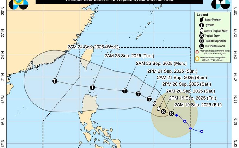
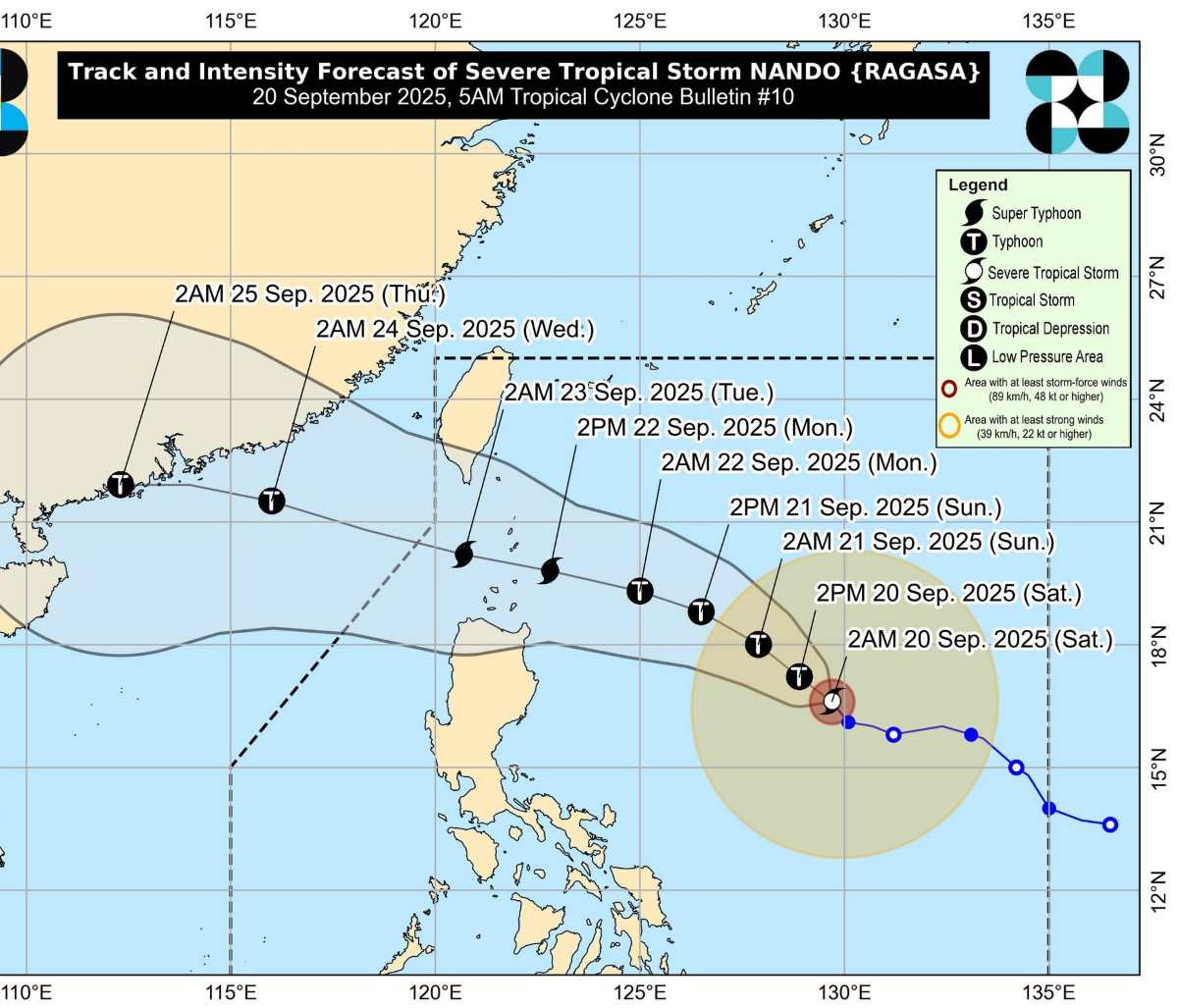
The latest storm information from the Philippine Atmospheric, Geophysical and Astronomical Services Administration (PAGASA) on the morning of September 20 said that Typhoon Ragasa (local name Nando) has strengthened into a severe storm and tends to continue to rapidly strengthen as it moves over the Philippine Sea.
PAGASA forecasts that Ragasa may reach super typhoon level just before approaching the Batanes and Babuyan Islands early next week (September 22).
At 5:00 a.m. on September 20, the center of the storm was at 16.7 degrees north latitude, 129.4 degrees east longitude, about 780 km east of Casiguran Town (Aurora, Philippines). The strongest wind near the center reaches 100 km/h, gusting up to 125 km/h, moving northwest at a speed of 10 km/h. PAGASA said that today, there is a possibility that a No. 1 wind warning will be issued for the Northern Luzon area.
According to the forecast track, the center of the storm could sweep across or make landfall directly on Batanes or Babuyan Islands from Monday afternoon to evening (22.9), then exit the Philippine Forecast Area (PAR) in the morning or afternoon of Tuesday (23.9).
As it moves, the storm is expected to continue to strengthen, reaching typhoon level in the next 12 hours and may become a super typhoon before approaching Northern Luzon.
The impact of the storm's low trough caused many areas to have prolonged thunderstorms. The Cagayan Valley, Bicol region, Eastern Visayas, Aurora and Quezon will have scattered showers, with the risk of thunderstorms.
Meanwhile, Metro Manila, Mimaropa, Pangasinan, the rest of Central Luzon and Calabarzon will also experience cloudy weather, with showers and thunderstorms due to the southwest monsoon triggered by the storm. The remaining areas of the Philippines will have localized showers due to the combined impact of monsoon and tropical thunderstorms.
Regarding the sea, the coastal areas east of Luzon are forecast to have moderate to strong winds, medium to high waves; the northern Luzon area has moderate winds, moderate rough seas. Other areas across the country will maintain light to moderate winds and light to moderate sea rough seas.
Meteorological experts warn that the intensification of Typhoon Ragasa will take place rapidly from today, September 20 to September 22. From September 22, the storm will reach its strongest intensity of level 15-16, gusting above level 17 when about 150km north-northeast of Luzon Island (Philippines).
Typhoon Ragasa is forecast to have an orbit in the East Sea and is likely to become the ninth typhoon of 2025. With a rapid strengthening, this storm is at risk of causing widespread heavy rain, strong winds and dangerous waves in the coming days.
People in Northern Luzon, especially Batanes and Babuyan, are advised to prepare for emergency response to the risk of strong storms making landfall. Meanwhile, countries along the East Sea, including Vietnam, need to closely monitor the developments of this "potential super typhoon" to have timely prevention scenarios.