This storm near the East Sea threatens to cause heavy rain, strong gusts of wind, dangerous high waves and the risk of flash floods and serious landslides.
The latest storm information from the Philippine Atmospheric, Geophysical and Astronomical Services Administration (PAGASA) said that at 4:00 a.m. on July 18, the center of Typhoon Wipha was at about 17.2 degrees north latitude, 124.8 degrees east longitude, about 335km east of Echague ( Isabela).
The strongest wind near the center of the storm reached 65km/h, gusting up to 80km/h, central pressure 996 hPa. The storm is moving northwest at a speed of 20km/h.
Worryingly, the area of strong to gusts of wind of level 6-8 extends up to 500km from the center of the storm, causing many areas in Northern Luzon to fall into a state of high alert.
According to the Philippine Atmospheric and Geophysical Agency (PAGASA), 18 provinces and areas in Luzon are currently in the area directly affected by the storm. A level 2 warning has been issued for areas such as: Cagayan (including Babuyan Islands), Batanes, Ilocos Norte, Ilocos Sur (North), Isabela (East), Apayao and part of Abra and Kalinga provinces. These areas face the risk of level 8-9 gusts of wind, which could cause minor to moderate damage to homes, crops and infrastructure.
Not only bringing strong winds, Typhoon Wipha also combined with the southwest monsoon, creating a wide range of rain covering most of Luzon, Visayas and part of Mindanao.
It is forecasted that from July 18-20, many areas including the capital Manila, the regions of CALABARZON, MIMAROPA, Western Visayas, Zamboanga and even Davao may experience prolonged heavy rain, increasing the risk of urban flooding, flash floods and landslides.
A warning of high waves and strong winds has also been issued since early this morning. According to PAGASA, the Batanes could see waves as high as 5 meters, while the northern Cagayan, Ilocos Norte and Isabela could see waves as high as 3.5 to 4 meters.
It is forecasted that in the next 12 hours, Typhoon Wipha will continue to move northwest and may make landfall in Cagayan province or Babuyan Islands this afternoon or evening (18.7). The storm will then pass through the northernmost part of Luzon and is expected to leave the Philippine forecast area tomorrow afternoon (July 19).
However, before leaving the mainland, Wipha is likely to strengthen into a strong tropical storm (Severe Tropical Storm) in the morning or afternoon of July 19.
Meanwhile, the storm forecast bulletin at 2:00 a.m. on July 18 of the Vietnam National Center for Hydro-Meteorological Forecasting said that storm Wipha will strengthen to level 8 (62-74 km/h), gusting to level 10.
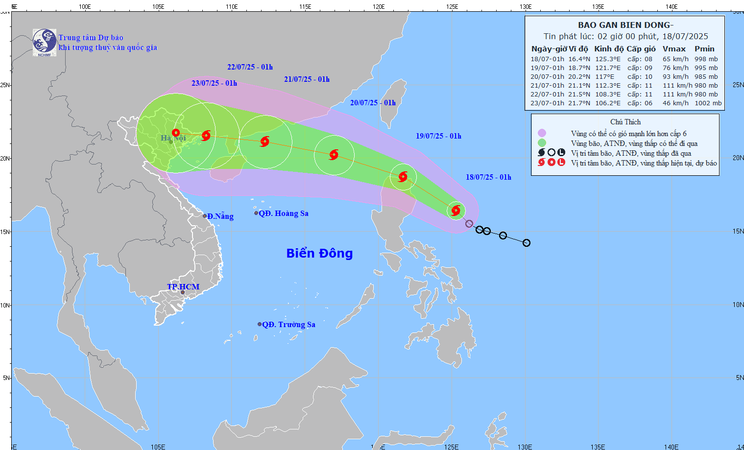
By 1:00 a.m. on July 19, Typhoon Wipha is expected to be at level 8-9, gusting to level 11, in the sea north of Luzon Island (Philippines).
By 1:00 a.m. on July 20, the storm is likely to enter the East Sea and strengthen, about 740 km east-southeast of Zhejiang Peninsula (China). Intensity: level 10, gust level 12. Natural disaster risk level: Level 3 in the northeastern sea area of the North East Sea
It is forecasted that by 1:00 a.m. on July 21, the storm will be at level 11, gusting to level 14, about 220km east of Zhejiang Peninsula (China). Natural disaster risk level: Level 3 in the northern sea area of the North East Sea.
From the afternoon of July 18, the northeastern sea area of the East Sea will have strong winds of level 6-7, gusting to level 9. Waves are 2.5-3.5m high, rough seas.