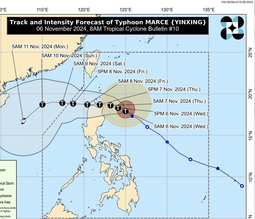
The latest storm bulletin from Philippine weather agency PAGASA said Typhoon Yinxing is slowing down as it moves over the Philippine Sea in the eastern part of Northern Luzon.
The bulletin released at 8:00 a.m. on November 6 said that the center of Typhoon Yinxing was 335 kilometers east of Tuguegarao City, Cagayan. The storm is currently moving slowly westward, with maximum sustained winds of 140 kilometers per hour near the center of the storm and gusts of up to 170 kilometers per hour.
PAGASA forecasters said that Typhoon Yinxing will mainly move west-northwest on November 6. The latest storm near the South China Sea is then forecast to turn westward from November 7 when it approaches the Babuyan Islands and northern Cagayan, Philippines.
According to the forecast track, Typhoon Yinxing will make landfall or approach the Babuyan Islands or the northern part of mainland Cagayan from the afternoon of November 7 to the morning of November 8. Typhoon Yinxing is expected to leave the PAR forecast area of the Philippines by the evening of November 8.
The storm, expected to become the seventh typhoon in the East Sea, will continue to strengthen and may reach its peak intensity on November 6 before making landfall or approaching Babuyan or Cagayan Islands on November 7, according to PAGASA.
Yinxing is the 13th typhoon of this year's typhoon season in the Philippines and the first typhoon in November. PAGASA forecasts that 1 to 2 typhoons may form within or enter the Philippine PAR forecast area in November.

Many computer storm forecasting models suggest that Typhoon Yinxing may be pushed southwest and enter the South China Sea, where it may weaken. Typhoon Yinxing is forecast to be about 400 km from Hong Kong (China) by November 10.
According to ABS-CBN's latest typhoon bulletin, PAGASA has warned Northern Luzon residents of heavy rains, strong winds and high waves due to Typhoon Yinxing.
"We should not only prepare for the rains. Typhoon Yinxing is forecast to intensify into a typhoon before making landfall, so there could be high waves in Cagayan," PAGASA expert Juanito Galang warned.
Typhoon Yinxing is forecast to continue to strengthen to typhoon strength over the Philippine Sea, so Mr. Galang urged people to prepare before the storm makes landfall.
"We will feel the severe impacts of Typhoon Yinxing before it makes landfall - as early as November 7 until the storm passes through Northern Luzon," he said.
Although the wind field of Typhoon Yinxing may be smaller than that of Typhoon Tra Mi (Kristine in the Philippines) and Super Typhoon Kong-rey (Leon in the Philippines), PAGASA forecasters warn of heavy rain and gusty winds. Tropical Storm Trami has already brought torrential rains to Southern Luzon while its path is in Northern Luzon. The fierce winds of Super Typhoon Kong-rey have devastated Batanes.
The circulation of Typhoon Yinxing brought rain to Northern Luzon and the eastern part of Luzon from late on November 5. However, forecasters in the Philippines said it was still early to assess the amount of rain from Typhoon Yinxing compared to that from Typhoon Tra Mi and Typhoon Kong-rey. In addition to bringing heavy rain and strong winds, Typhoon Yinxing is also forecast to increase the northeast monsoon this week in the Philippines.


