The East Sea faces the risk of strong storms due to La Nina

Khánh Minh |

La Nina could form before the end of 2025, increasing the risk of strong storms and heavy rains in the East Sea.

The Philippine Atmospheric, Geophysical and Astronomical Services Administration (PAGASA) said that the neutral ENSO phenomenon ( El Nino - Southern fluctuations) is likely to last until October. However, climate models show a high probability of a short-term La Nina occurring between September and December, with a chance of over 55%.

La Nina is a cold phase of ENSO, characterized by colder-than-average sea surface temperatures in the central and eastern equatorial Pacific. This phenomenon often causes the number of tropical storms and super typhoons to increase sharply towards the end of the year, and causes unusually heavy rain, leading to the risk of widespread flooding and landslides.

PAGASA emphasized: History shows that previous La Nina rains have always been associated with severe monsoons, severe agricultural damage and deep flooding in many areas. This agency called on local authorities, natural disaster prevention forces and people to promptly prepare and proactively take response measures.

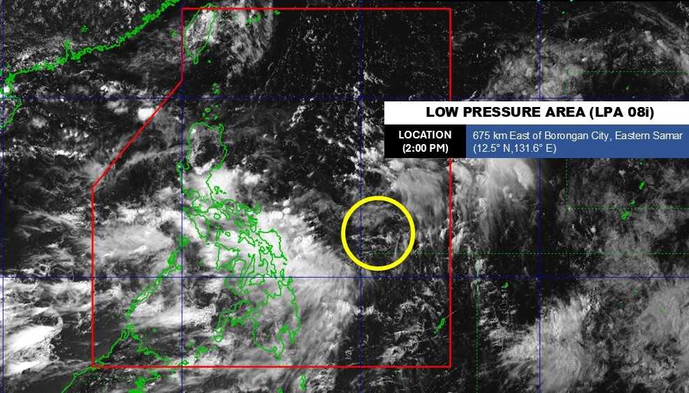
Currently, at 2:00 p.m. on August 31, a low pressure area (LPA 08i) is being monitored within the Philippine Forecast Area (PAR). The center of the low pressure is located at 12.5 degrees north latitude, 131.6 degrees east longitude, 675km east of Borongan City, Eastern Samar.

Although there is a low possibility of developing into a tropical depression in the next 24 hours, this is considered a notable signal in the context of storm No. 6 in the East Sea having just dissipated.

Vi tri tam ap thap 08i hoi 14h ngay 31.8.2025. Anh: PAGASA
Location of the center of low pressure 08i at 2:00 p.m. on August 31, 2025. Photo: PAGASA

Not only PAGASA, meteorologists from the US National Oceanic and Atmospheric Administration (NOAA) have also issued a La Nina Watch warning, and forecast that the world is likely to maintain a neutral ENSO state until the end of 2025 and the whole year of 2026. However, if La Nina occurs, it may only last for a short time before turning to neutral.

According to NOAA, ENSO often operates as a current between La Nina and El Nino, each lasting from 9 months to 1 year, but not in a fixed cycle. It is this unusual thing that makes storms in the Pacific and the East Sea increasingly unpredictable.

In the context of strong climate change, the possibility of La Nina appearing at the end of this year means that the 2025 storm season in the East Sea is at risk of becoming more severe, requiring countries in the region to raise their vigilance and proactively respond early.

Khánh Minh
RELATED NEWS

Storm No. 6 Nongfa has just dissipated and appeared 2 new low pressure areas in a row

|

After Typhoon No. 6 Nongfa weakened and dissipated, the Philippine Meteorological Agency continued to monitor two new low pressure areas at the same time.

The biggest danger forecast from storm No. 6 Nongfa for Central Vietnam

|

The most worrying point of Typhoon No. 6 Nongfa is not the wind power, but the amount of rainfall caused by the storm in areas that have not yet recovered from Typhoon No. 5 Kajiki.

Potential storm No. 6 has not yet made landfall in the Central region, new low pressure has appeared

|

The tropical depression in the East Sea is expected to strengthen into storm No. 6 and make landfall in Central Vietnam on the evening of August 30, while a new low pressure has appeared.

The streets of Ho Chi Minh City are brightly decorated with flags and flowers, celebrating the 80th anniversary of National Day on September 2

|

HCMC - These days, the streets of the city named after Uncle Ho are filled with the colorful flags and flowers of the people celebrating National Day on September 2.

Many experiences in watching the A80 parade successfully

|

The commemoration, parade, and parade to celebrate the 80th anniversary of the August Revolution and National Day on September 2 are solemn events. Tourists should prepare carefully.

Hanoi wears red flag with yellow star, brilliantly celebrating the National Day

|

Hanoi - These days, the capital is brilliant with the red flag with yellow star, wearing a heroic and atmospheric appearance to welcome the September 2 holiday.

Inside the military equipment gathering place before the 2.9 parade

|

Hanoi - Many people flocked to the F1 racetrack to watch the blocks of vehicles, military fireworks, and police special vehicles practicing before the parade and parade on the occasion of the 80th anniversary of National Day.

To receive National Day gifts, a woman went into labor and received additional gifts

|

Quang Tri - When coming to the commune to receive a National Day gift, the woman suddenly gave birth at the health station, then was supported to make a birth certificate to receive an additional gift.

Storm No. 6 Nongfa has just dissipated and appeared 2 new low pressure areas in a row

Song Minh |

After Typhoon No. 6 Nongfa weakened and dissipated, the Philippine Meteorological Agency continued to monitor two new low pressure areas at the same time.

The biggest danger forecast from storm No. 6 Nongfa for Central Vietnam

Song Minh |

The most worrying point of Typhoon No. 6 Nongfa is not the wind power, but the amount of rainfall caused by the storm in areas that have not yet recovered from Typhoon No. 5 Kajiki.

Potential storm No. 6 has not yet made landfall in the Central region, new low pressure has appeared

Khánh Minh |

The tropical depression in the East Sea is expected to strengthen into storm No. 6 and make landfall in Central Vietnam on the evening of August 30, while a new low pressure has appeared.