Low pressure forecast near the East Sea in the next 2 weeks

Thanh Hà |

The low pressure near the East Sea is forecast to appear in the last days of February and early March.

The latest storm and low pressure forecast bulletin on February 21 of the Philippine Atmospheric, Geophysical and Astronomical Services Administration (PAGASA) stated that during the week from February 21 to 27, storm and low pressure forecast models found that there was little chance of a low pressure appearing in the East Sea and near the East Sea.

However, it is forecasted that during the week from February 28 to March 6, a new low pressure is likely to form east of Mindanao and Visayas, Philippines. This low pressure near the East Sea is unlikely to strengthen into a tropical storm.

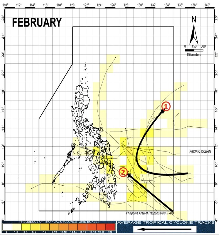
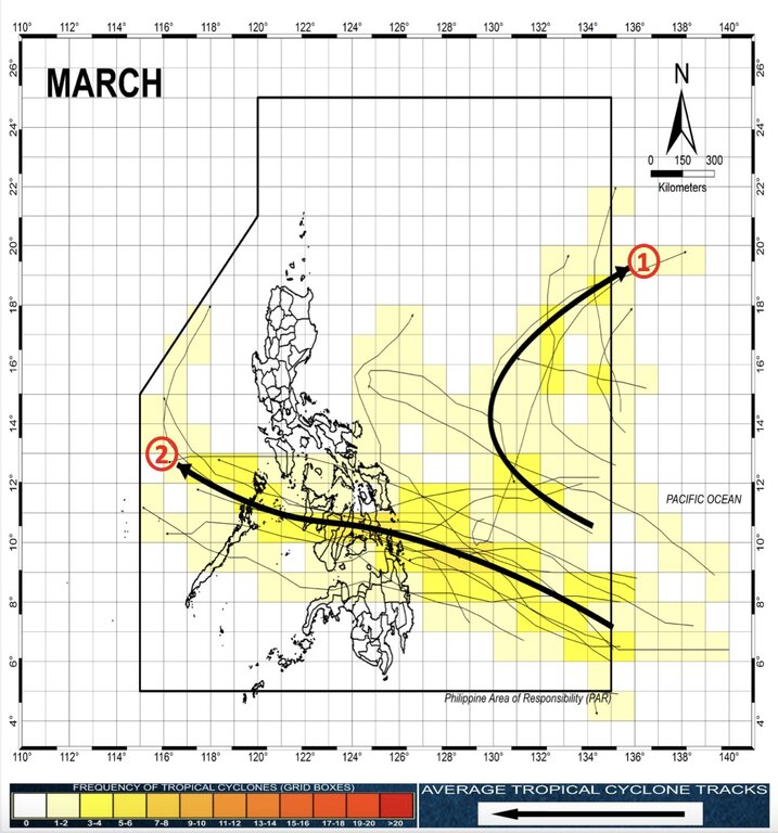
In the bulletin, PAGASA also outlined a scenario for the forecast path of tropical cyclones forming in the Philippine PAR forecast area in February and March, although the storm is unlikely to appear in the two months.

In February, the path of storms near the East Sea will have 2 directions: First, storms form in the western Pacific then enter PAR and return to the Pacific; Second, storms form in the western Pacific, enter PAR and head straight towards the Philippine mainland but dissipate before making landfall.

Typhoons in March near the Philippines typically go in two directions: First, storms form in the Western Pacific then enter PAR and circle back into the Pacific; Second, storms form in the Western Pacific, enter PAR and make landfall in the central Philippines before entering the East Sea and dissipating in the East Sea.

The Philippines will see at least 18 typhoons in the 2024 typhoon season, including at least 6 strong typhoons Kristine (Trami), Leon (Kong-Rey), Marce (Yinxing), Nika (Toraji), Ofel (Usagi), Pepito ( Man Yi) that will appear from October to November 2024.

For the 2025 typhoon season, the Philippines has announced 25 typhoon names to name when the typhoon enters the PAR forecast area - an area designated by the World Meteorological Organization for the Philippine weather agency to monitor the weather.

The storm names for the 2025 typhoon season in the Philippines include: Auring, Bising, Crising, Dante, Emong, Fabian, Gorio, Huaning, Isang, Jacinto, Kiko, Lannie, Mirasol, Nando, Opong, Paolo, Quedan, Ramil, Salome, Tino, Uwan, Verbena, Wilma, Yasmin, Zoraida.

PAGASA names tropical storms locally as they enter the PAR forecast area. This practice began in 2019.

Thanh Hà
RELATED NEWS

Shocking forecast of future storm developments

|

The number of storms is forecast to double, becoming stronger in intensity and frequency over the next decade in the Atlantic.

Storm and low pressure forecast near the East Sea in the second half of February

|

According to the latest storm news, there are currently no storms in the East Sea, but strong northeast winds cause natural disaster risks.

Forecast of the probability of storms near the East Sea after low pressure

|

The tropical depression in the East Sea did not strengthen into a storm but weakened into a low pressure area.

Dumping garbage right under the no-entry sign, next to schools, people propose installing AI cameras

|

Hanoi - The situation of littering domestic waste indiscriminately in some areas of Ngoc Ha ward causes pollution, people hope to soon install AI cameras to monitor and handle it.

Oil and gas stocks strongly profit-taken after a series of hot days of increase

|

After a few strong breakthrough sessions thanks to benefiting from Middle East tensions, oil and gas stock groups faced strong profit-taking pressure and simultaneously fell to the floor price.

Iran announces missile launch to burn US oil tanker

|

Iran claims to have attacked a US oil tanker in the Persian Gulf, threatening to block all ships linked to the US or Israel through the Strait of Hormuz.

Forecast of the start time and intensity of summer heat this year

|

It is forecast that summer heat in 2026 will appear early, last longer and increase in intensity compared to the multi-year average.

Shocking forecast of future storm developments

Thanh Hà |

The number of storms is forecast to double, becoming stronger in intensity and frequency over the next decade in the Atlantic.

Storm and low pressure forecast near the East Sea in the second half of February

Khánh Minh |

According to the latest storm news, there are currently no storms in the East Sea, but strong northeast winds cause natural disaster risks.

Forecast of the probability of storms near the East Sea after low pressure

Song Minh |

The tropical depression in the East Sea did not strengthen into a storm but weakened into a low pressure area.