The latest storm and low pressure forecast by the Philippine Atmospheric, Geophysical and Astronomical Services Administration (PAGASA) on February 5 said that two low pressure areas are expected to appear in the East Sea and one low pressure area near the East Sea between February 5 and February 18.
PAGASA forecasters said the first low pressure system will form in the South China Sea during the week of February 5-11. The latest low pressure system is expected to develop in the southwestern part of the Philippine PAR forecast region. Typhoon experts said that this low pressure system is unlikely to strengthen into a typhoon in the South China Sea.
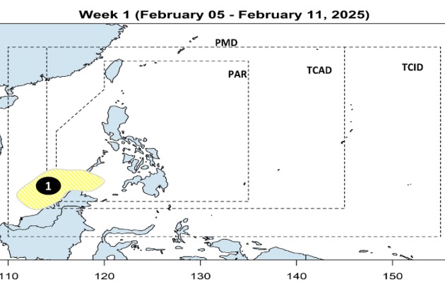
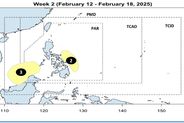
During the forecast period from February 12 to 18, PAGASA’s typhoon forecast models predict that two depressions will form within PAGASA’s PAR forecast area. Both of these depressions have a low probability of strengthening into tropical storms.
A low pressure area near the South China Sea is expected to form near eastern Visayas and Mindanao, Philippines. Meanwhile, a low pressure area over the South China Sea is likely to develop southwest of the PAR.
Previously, in the storm and low pressure forecast for February 3, PAGASA stated that during the week from February 3 to February 9, a new low pressure is expected to form near the Philippines. The new low pressure is likely to appear south of the PAR forecast area and is likely to enter the East Sea.
The second low pressure is expected to be formed in the East of the Philippines from 10 to 16.2.
Both low pressure areas in PAGASA's February 3 forecast are considered unlikely to strengthen into storms.
In its 2025 typhoon season forecast, PAGASA said that 19 to 20 storms are expected to enter the PAR forecast area. Of those, one is likely to appear by the end of February. Meanwhile, March is forecast to see one or no storms forming near the Philippines, PAGASA chief Nathaniel Servando told the Manila Times.
In addition, PAGASA also announced a list of 25 storm names for the 2025 storm season, including: Auring, Bising, Crising, Dante, Emong, Fabian, Gorio, Huaning, Isang, Jacinto, Kiko, Lannie, Mirasol, Nando, Opong, Paolo, Quedan, Ramil, Salome, Tino, Uwan, Verbena, Wilma, Yasmin and Zoraida.
PAGASA also prepared 10 additional backup storm names for the 2025 typhoon season, including Alamid, Bruno, Conching, Dolor, Ernie, Florante, Gerardo, Hernan, Isko and Jerome.
The 2024 typhoon season in the Philippines recorded 17 storms, with 6 of these storms appearing in the last 3 months of the year, causing heavy damage.
The 2024 typhoon season report in the Philippines compiled by Reliefweb.int shows that 6 strong storms have hit Luzon, Philippines in just 25 days, causing damage to the Bicol, Cagayan Valley, Central Luzon, Cordillera and Ilocos regions. The first strong storm in this series was Typhoon Kristine (international name: Typhoon Trami), which brought heavy rains to 17 regions of the Philippines, leading to floods and landslides.