The latest storm news from the Philippine Atmospheric, Geophysical and Astronomical Services Administration (PAGASA) this week said that 4 to 11 tropical storms may affect the Philippines from February to July 2026.
At the 192nd Climate Forum on January 21, PAGASA weather forecaster Joseph Basconcillo said that the number of tropical storms will increase from February to July.
From February to April 2026, PAGASA forecasts that there will be 0 to 1 storm per month, while May and June may have 1 to 2 storms per month.
The number of tropical storms will then increase in July, with 2 to 4 storms expected to affect the Philippines.
According to PAGASA, the number of areas with "dry days" is higher from February to April, while from May to July, many areas will have more rainy days. "Dry days" are days with rainfall below 1mm.
Regional analysis shows that from February to May, the western areas of northern and central Luzon will have rainfall from low to below average, while the areas of Mimaropa, Bicol and western Visayas will have rainfall below average in some months.
Most of Visayas and Mindanao are forecast to record near-average rainfall, with some points having rainfall below average and above average.
Rain forecast for June and July near normal across the Philippines.
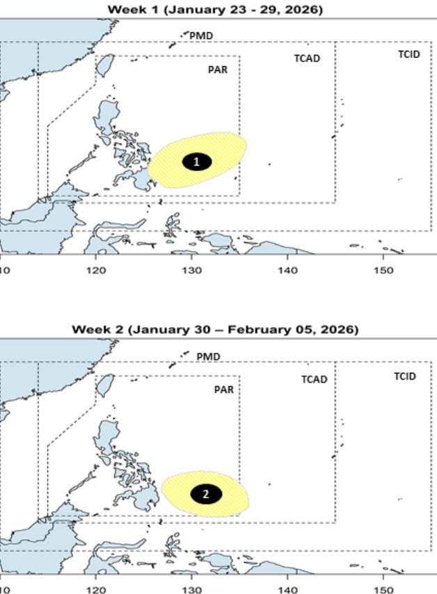
According to PAGASA's short-term storm and low pressure forecast announced on January 23rd, 2 low pressure areas are expected to form near the Philippines from now until February 5th.
Accordingly, the first low pressure area is expected to form in the week from January 23 to January 29 in the southeast of the Philippine Area of Forecast (PAR) with little possibility of strengthening into a storm or tropical depression.
The second low pressure is expected to appear in the southeast of PAR and is also unlikely to strengthen.
Regarding the weather forecast for January 24, PAGASA said that northeast monsoon and intermittent winds are forecast to cause widespread showers across the Philippines.
Areas in Luzon expected to be cloudy and with showers include: Cagayan Valley, Apayao, Calinga, Mountain Province, Ifugao, Aurora, Quezon, Oriental Mindoro, Marinduque, Bicol Region
The remaining areas of Luzon, including Metro Manila, are expected to be cloudy to foggy with the possibility of light rain.
In Palawan and Visayas, it is forecast to be cloudy to gloomy, with the possibility of light rain, especially Eastern Samar and Southern Leyte are forecast to have heavy rain due to contact between the northeast monsoon and the east wind.
Meanwhile, the low pressure area (formerly Typhoon Ada) is 560km east of Hinatuan, Surigao del Sur and is unlikely to strengthen.
PAGASA's forecaster Eastareja said that it is highly likely that this low pressure area will dissipate in the coming days as it moves near the eastern area of Mindanao.


