
On August 27, according to storm and low pressure news from the Philippine Atmospheric, Geophysical and Astronomical Services Administration (PAGASA), after forecasting 5 ridges likely to form or enter the monitoring area in the period from August 26 to September 8, PAGASA updated that there are currently 3 ridges likely to form or enter the monitoring area in the period from August 27 to September 9.
In the week from August 27 to September 2, there are currently no storms in the PAGASA Monitoring Region (PMD).
However, a vortex characterized by tropical cyclones (TCLV) is forecast to form in the Philippine Area of Responsibility (PAR), with a high probability of developing into a storm.
Another vortex, coded TCLV (2), is forecast to form in the eastern boundary area of Tropical Cyclone Information Zone (TCID) and Tropical Cyclone Warning Zone (TCAD). The possibility of TCLV (2) developing into a storm in the week from August 27 to September 2 is assessed from low to medium.
Next week from September 3 to 9, TCLV (2) is forecast to move closer to the northeastern boundary of PAR. The possibility of developing into a storm of this vortex is assessed from low to medium.
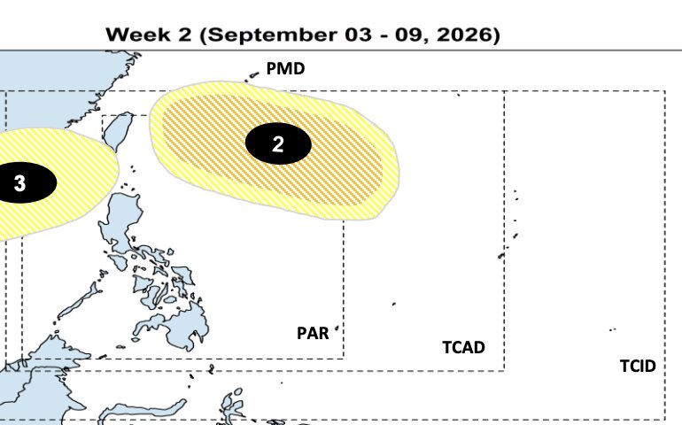
Meanwhile, another TCLV (3) region is likely to form in the northwest area of PMD. PAGASA assesses the possibility of TCLV 3 developing into a storm at a low level.
Thus, compared to previous forecasts, the number of cyclones monitored by PAGASA in the next 2 weeks has decreased from 5 to 3. However, PAGASA still warns of the risk of tropical cyclones appearing at a high level next week and are likely to continue to appear in the following week.
PAGASA recommends that people continue to follow the latest weather bulletins to update on changes in forecasts, especially about the location and development potential of cyclones in the coming days.


