Forecast of the possibility of consecutive super typhoons appearing in October

Song Minh |

Record high sea temperatures make it entirely possible for super typhoons to appear consecutively in October.

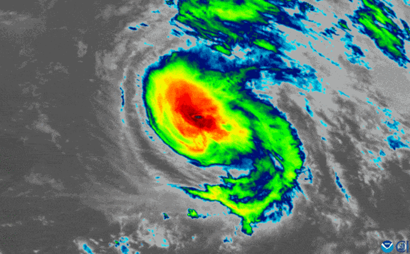
After a slow start, the 2025 Atlantic hurricane season suddenly exploded with Hurricane Humberto - the third strongest storm and the second Category 5 superstorm of the year.

Meanwhile, Tropical Depression 9 is also increasing in strength, threatening to bring heavy rain and flash flooding to the southeastern coastal areas of the United States.

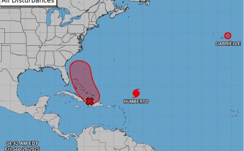
The latest storm news on September 28 from the US National Hurricane Center (NHC) confirmed that Hurricane Humberto has rapidly intensified, reaching winds of 257 km/h, surpassing the Category 5 storm threshold - the strongest level on the Saffir-Simpson hurricane scale. Hurricane Humberto is currently currently weaving about 560km north-northeast of the Leeward Islands and is expected to maintain the intensity of a super typhoon for many days to come.

Anh: NOAA
Superstorm Humberto reached 257 km/h winds on September 28. Photo: NOAA

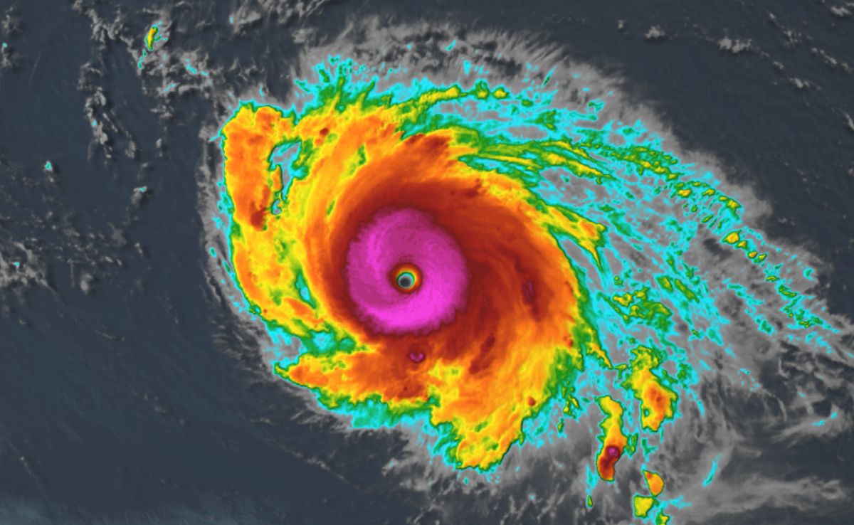
According to the NHC, although it is unlikely to make landfall directly on the US mainland in the next few days, Humberto will still create extremely dangerous high waves and offshore flows. High waves are expected from the Caribbean, Puerto Rico, Bermuda to the East Coast early this week. Some hydrological buoys have recorded waves 3m higher as the center of the storm is still hundreds of kilometers away.

These waves could cause rough seas and death by offshore rushing, the NHC warned.

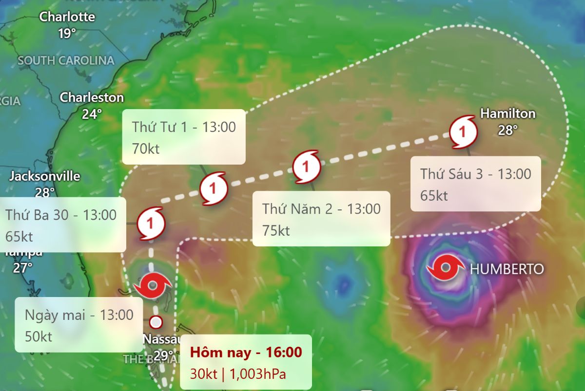
In parallel with Hurricane Humberto, Tropical Depression 9 is also gradually strengthening as it moves slowly in northwestern Cuba. According to the NHC's storm forecast, on September 29 local time, the depression will strengthen into storm Imelda, possibly even intensifying in the middle of this week.

Typhoon Humberto (right) and Depression No. 9 (left) on September 28. Video: NOAA

As Imelda approaches the US mainland, coastal areas from Georgia, the two states of Carolina to the Central Atlantic coast could experience flash flooding, urban flooding and river flooding.

North Carolina Governor Josh Stein declared a state of emergency on September 28 in preparation for heavy rain and flooding risks.

The South Carolina governor has also declared a state of emergency, urging people to closely monitor weather forecasts and proactively prepare for response.

Du bao duong di cua sieu bao Humberto va bao Imelda tiem nang. Anh: Windy.com
Forecast of potential path of Imelda. Photo: Windy.com

The 2025 Atlantic hurricane season is expected to be more active than average, but it will not really take off until late September. In less than two weeks, the Atlantic has seen three major hurricanes in a row: Hurricane Erin, Hurricane Gabrielle and now Humberto.

According to meteorologist Philip Klotzbach ( Colorado State University), this is the first time since 2015, that the first three storms of the season have reached major hurricane status (level 3 or higher).

Experts warn that record-high sea temperatures of nearly 31 degrees Celsius are providing abundant fuel for storms, making it entirely possible for super typhoons to appear consecutively in October.

Song Minh
RELATED NEWS

Hurricane Paolo forecast after storm No. 10 Bualoi in early October

|

As soon as Typhoon No. 10 Bualoi left the Philippines, a new disturbance area appeared that could strengthen into Typhoon Paolo.

Danger of dangerous double storm, Imelda may cause historic heavy rain

|

The double Threat of Humberto - Imelda is lurking, with the next storm Imelda being a concern, forecast to bring heavy rain and severe flooding in the US.

Storm No. 10 quickly makes landfall in Central Vietnam after devastating the Philippines

|

Storm No. 10 is forecast to move nearly double the average speed, heading towards Central Vietnam after devastating the Philippines, killing many people.

Forecast of heavy rain, strong winds due to super typhoon Gabrielle

|

An urgent warning was issued on September 24 as super typhoon Gabrielle, a Category 4 storm with winds of 220 km/h, approached the Atlantic. The Pacific Ocean has another storm Narda.

9 crew members missing on the Gianh River in Quang Tri

|

Quang Tri - At the traditional anchorage area of fishermen on the North bank of Gianh River, 2 fishing boats drifted, leaving 9 crew members missing.

Rescuing 8 people in Nghe An trapped after storm No. 10

|

Nghe An - Fire police promptly rescued 8 victims trapped due to houses and constructions blown off in storm No. 10.

Da River dries up in the rainy season, revealing many sand dunes at the foot of hydropower plant

|

Phu Tho - The water level of the Da River has dropped, many sand dunes and rocky beaches are clearly visible at the foot of the Hoa Binh Hydropower Plant, creating a unique landscape.

Duc Phuc: I spent billions of dong, I wanted the audience to hold their breath for 3 minutes, and have goosebumps

|

After winning the Intervision 2025 international music competition, Duc Phuc shared about his international journey and a gift for his parents.

Hurricane Paolo forecast after storm No. 10 Bualoi in early October

Khánh Minh |

As soon as Typhoon No. 10 Bualoi left the Philippines, a new disturbance area appeared that could strengthen into Typhoon Paolo.

Danger of dangerous double storm, Imelda may cause historic heavy rain

Song Minh |

The double Threat of Humberto - Imelda is lurking, with the next storm Imelda being a concern, forecast to bring heavy rain and severe flooding in the US.

Storm No. 10 quickly makes landfall in Central Vietnam after devastating the Philippines

Khánh Minh |

Storm No. 10 is forecast to move nearly double the average speed, heading towards Central Vietnam after devastating the Philippines, killing many people.

Forecast of heavy rain, strong winds due to super typhoon Gabrielle

Châu Anh |

An urgent warning was issued on September 24 as super typhoon Gabrielle, a Category 4 storm with winds of 220 km/h, approached the Atlantic. The Pacific Ocean has another storm Narda.