Forecast of more low pressure likely to enter the East Sea

Thanh Hà |

The low pressure near the East Sea will have the first effects on the weather in the Philippines and a new low pressure is forecast to enter the East Sea in the coming weeks.

The latest storm and low pressure information from the Philippine Atmospheric, Geophysical and Astronomical Services Administration (PAGASA) said that the low pressure area located in the northern part of the Sulu Sea will continue to cause rain in many areas of the Philippines on May 8.

According to PAGASA weather expert Benison Estareja, the low pressure was last detected 80 km northeast of Cuyo, Palawan, Philippines.

"This low pressure is not yet forecast to become a storm and is likely to dissipate within the next 24 hours. However, the low pressure will still bring rain to much of Southern Luzon, the Visayas and northern Mindanao, said Benison Estareja, a weather expert.

Ap thap gan Bien Dong dang cach Cuyo, Palawan, Philippines 80 km ve phia dong bac. Anh: PAGASA
The low pressure near the East Sea is 80 km northeast of Cuyo, Palawan, Philippines. Photo: PAGASA

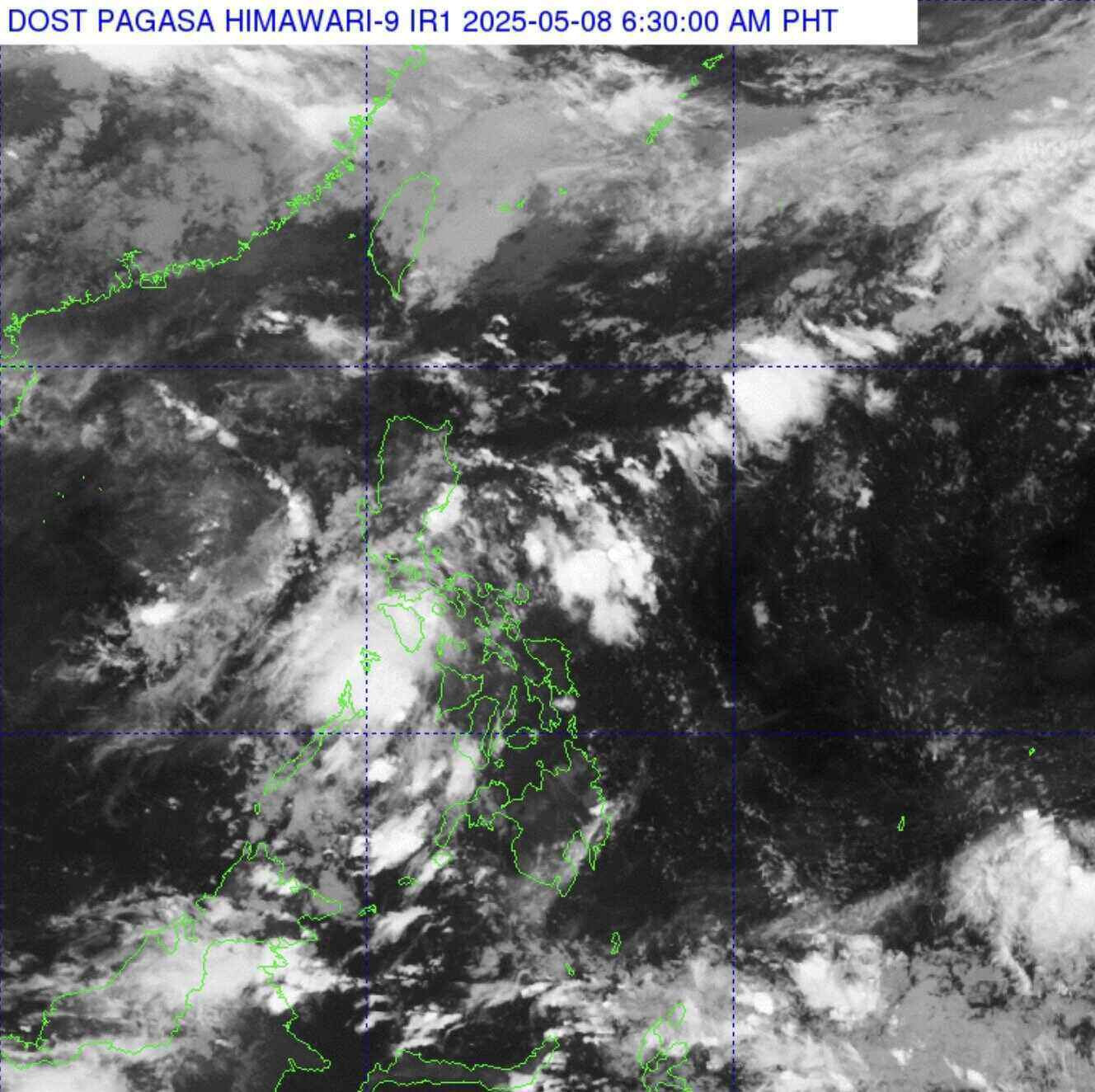
Meanwhile, PAGASA's weather bulletin on May 8 also noted that the easterly winds will cause rain in the rest of the Philippines, especially in eastern Luzon, Metro Manila area, as well as eastern Mindanao.

In the rest of Luzon and Mindanao, the sky is cloudy to clear with the possibility of scattered thunderstorms, especially in the afternoon and evening.

According to the latest storm forecast on May 7 from PAGASA, right after the low pressure is active near the East Sea, a new low pressure is forecast to form and is likely to enter the East Sea.

The bulletin said that during the week from May 14 to May 20, the low pressure near the East Sea is expected to appear at the eastern boundary of the Philippine PAR forecast area.

Du bao ap thap moi co kha nang di vao Bien Dong trong tuan tu ngay 14.5 den 20.5. Anh: PAGASA
The new low pressure is forecast to enter the East Sea during the week of May 14 to May 20. Photo: PAGASA

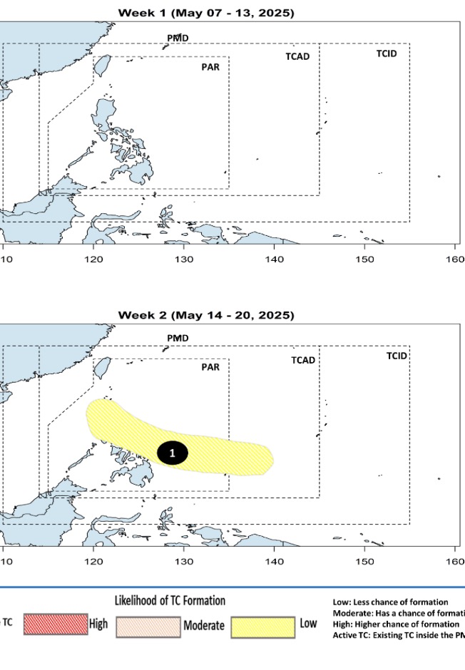
Current forecast models predict that this low pressure will have little chance of strengthening into a storm. However, throughout the forecast period, this low pressure will move northwest, near Visayas and Southern Luzon, with the possibility of passing through the Philippines and entering the East Sea.

PAGASA's early May forecast bulletin said that there are forecasts for 1 to 2 storms forming in the PAR area this month. At that time, PAGASA weather expert Benison Estareja predicted that the likelihood of typhoons would increase as the Philippines was entering the typhoon season.

"This year, in May 2025, we are expecting one or two tropical storms. The first will be named Auring, followed by Bising," he said.

An average of 20 typhoons occur in the Philippines each year, with 8-9 of them likely to make landfall. January to May every year is often considered a quiet period for tropical depression and storm activity in the northwest Pacific basin, an area that includes the Philippines.

According to PAGASA, in May and June, there may be 1 to 2 storms forming or entering the Philippine forecast area. From July, August and September 2025, there will be 2 to 3 storms/month.

Thanh Hà
RELATED NEWS

2 consecutive low pressure areas appear around the East Sea

|

The low pressure near the East Sea appeared in the context of the low pressure in the East Sea that has been active for the past few days.

East Sea welcomes consecutive low pressure, early signal for the 2025 storm season

|

The low pressure in the East Sea is forecast to move north of the East Sea in the next few days.

New low pressure appears soon, forecast to have 2 storms near the East Sea in May

|

The latest storm forecast from the Philippine Atmospheric, Geophysical and Astronomical Services Administration (PAGASA) predicts two storms near the East Sea in May.

Hanoi will develop bus routes on the basis of BRT fast bus routes

|

In the 2030-2035 period, Hanoi will develop bus routes on the BRT express bus route and urban railway, attracting people to use public transport.

Experts talk about the issue of increasing retirement age

|

Many opinions say that it is necessary to improve the skills and productivity of young workers to promote economic growth instead of extending the retirement age.

Mr. Tran Huy Tuan was elected to hold the position of Chairman of the Ninh Binh Provincial People's Committee

|

Ninh Binh - On the afternoon of November 12, Mr. Tran Huy Tuan - Deputy Secretary of the Ninh Binh Provincial Party Committee was elected by the Provincial People's Council to hold the position of Chairman of the Provincial People's Committee with 100% of the votes.

Current status of Can Tho Stadium proposed to be relocated

|

Can Tho - After being renovated in 2019, Can Tho Stadium now has many items that are gradually deteriorating.

Da Nang discusses solutions to urgently salvage the ancient ship that was just discovered on Hoi An coast

|

The Hoi An Cultural Heritage Conservation Center and the Department of Culture, Sports and Tourism of Da Nang City discuss and find solutions to salvage and relocate ancient ships on the coast of Cam An.

2 consecutive low pressure areas appear around the East Sea

Thanh Hà |

The low pressure near the East Sea appeared in the context of the low pressure in the East Sea that has been active for the past few days.

East Sea welcomes consecutive low pressure, early signal for the 2025 storm season

Thanh Hà |

The low pressure in the East Sea is forecast to move north of the East Sea in the next few days.

New low pressure appears soon, forecast to have 2 storms near the East Sea in May

Thanh Hà |

The latest storm forecast from the Philippine Atmospheric, Geophysical and Astronomical Services Administration (PAGASA) predicts two storms near the East Sea in May.