The Philippine Atmospheric, Geophysical and Astronomical Services Administration (PAGASA) said that storm Today (storm No. 2 in the East Sea) will strengthen into a severe tropical storm within the next 24 hours.
At 2:00 a.m. on July 5, the center of the low pressure was at about 20.5 degrees north latitude, 117.5 degrees east longitude, in the northeastern sea of the North East Sea, 465 km west of Basco, Batanes. Maximum winds near the center of the storm are 85 km/h, gusting to 105 km/h. The storm is moving east-northeast at 10 km/h.
Storm leo is forecast to intensify into a severe tropical storm in the next 24 hours and is expected to maintain its intensity as it passes through the Taiwan Strait (China). The typhoon is expected to weaken on July 8 when it interacts with the mainland in eastern China, PAGASA explained.
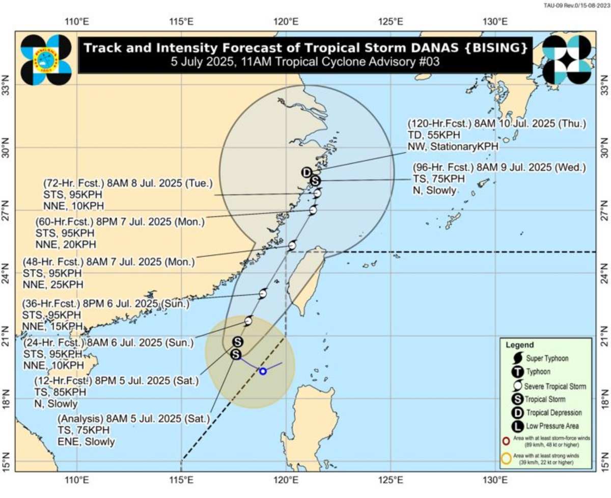
A land warning for Typhoon No. 2 Danas could be issued in Taiwan as early as late as July 5, as the outer reaches of the typhoon begin to bring heavier rain to southeastern areas, including Hualien, Taitung and the Taitung Peninsula, according to the Taiwan Meteorological Administration (China) CWA.
CWA Wu Wan-hua forecaster said today's storm "ays" is expected to move south of the Taiwan Strait, with the most significant impacts expected between July 6 and the morning of July 7. The time of the warning on land will depend on the trajectory and speed of the storm.
The warning of heavy rain has come into effect for the Hang Xuan Peninsula. The rain is expected to gradually move northward on July 5, to central and eastern Taiwan (China), as well as offshore islands such asutes and Kim Mon.
localized heavy rains are also expected in southern and southeastern Taiwan (China), while northern regions may experience thunderstorms in the afternoon.
The storm forecast bulletin of the Vietnam National Center for Hydro-Meteorological Forecasting said that at 1:00 p.m. on July 6, the center of storm No. 2 was at about 22.2 degrees north latitude, 118.2 degrees east longitude; in the northeastern sea of the East Sea. The storm is level 10-11, gusting to level 13, moving in the North Northeast direction, 5-10 km/h and is likely to strengthen. The northeastern sea area of the North East Sea is subject to level 3 natural disaster risk.
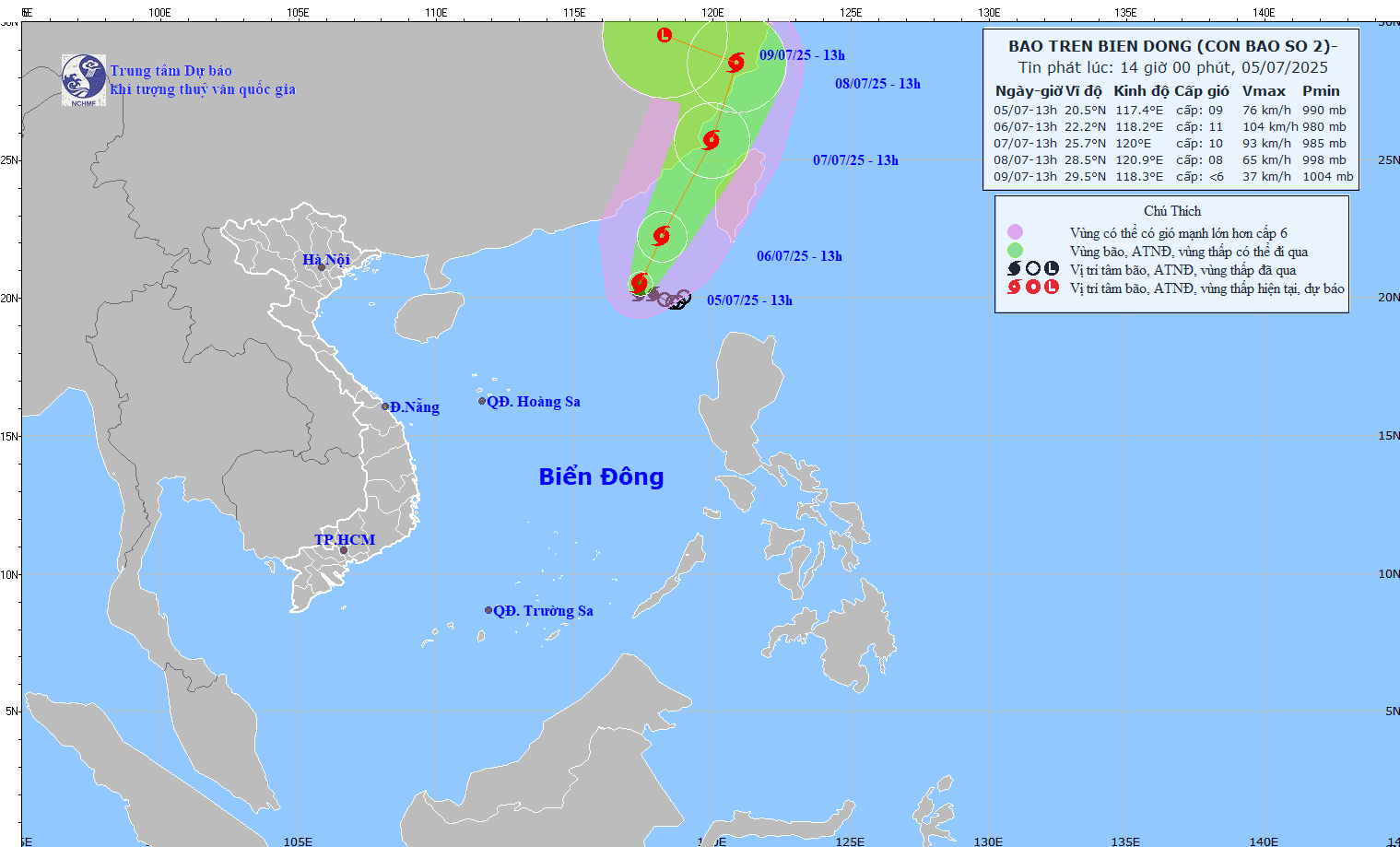
It is forecasted that by 1:00 p.m. on July 7, the center of storm No. 2 will be at about 25.7 degrees north latitude, 120.0 degrees east longitude; in the waters of Fujian province (China). Storm intensity level 10, gusts level 12, moving in the North Northeast direction, 15-20 km/h and likely to strengthen. The northeastern sea area of the North East Sea is subject to level 3 natural disaster risk.
Forecast of storm impact: Strong winds, big waves.
The northeastern sea area of the North East Sea will have storms and strong winds of level 7-8, near the storm's eye level 9-11, gusting to level 13. The sea is rough, with waves 4.0-6.0m high.
Ship operating in the danger zone are at high risk of being affected by thunderstorms, tornadoes, strong winds and large waves.