Forecast of the path and most severely affected area of storm No. 2 Bising

Khánh Minh |

When the tropical depression in the East Sea strengthens into storm No. 2 Bissing, it will cause coastal provinces to face heavy rain, rough seas, and waves 3-5m high.

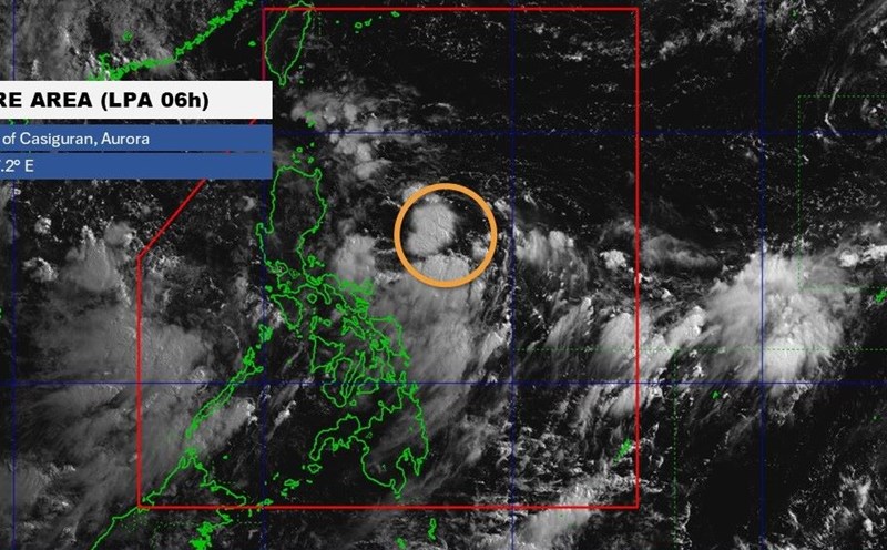
The latest storm information from the Philippine Atmospheric, Geophysical and Astronomical Services Administration (PAGASA) said that on the morning of July 4, the tropical depression in the East Sea is strengthening and is likely to become storm No. 2 Bising as it moves slowly west-southwest over the western sea of Northern Luzon.

At 1:00 p.m. on July 4, the center of Bising was at about 19.8 degrees north latitude, 118.6 degrees east longitude, about 220 km northwest of Laoag City, Ilocos Norte, Philippines. Bising moved at a speed of about 15 km/h, with maximum sustained winds of 55 km/h, gusting up to 70 km/h.

Bising is expected to continue moving slowly and may exit the Philippine Forecast Area (PAR) in the afternoon of July 4. However, according to PAGASA, the system is likely to return by the morning of July 6, depending on interaction with surrounding weather systems.

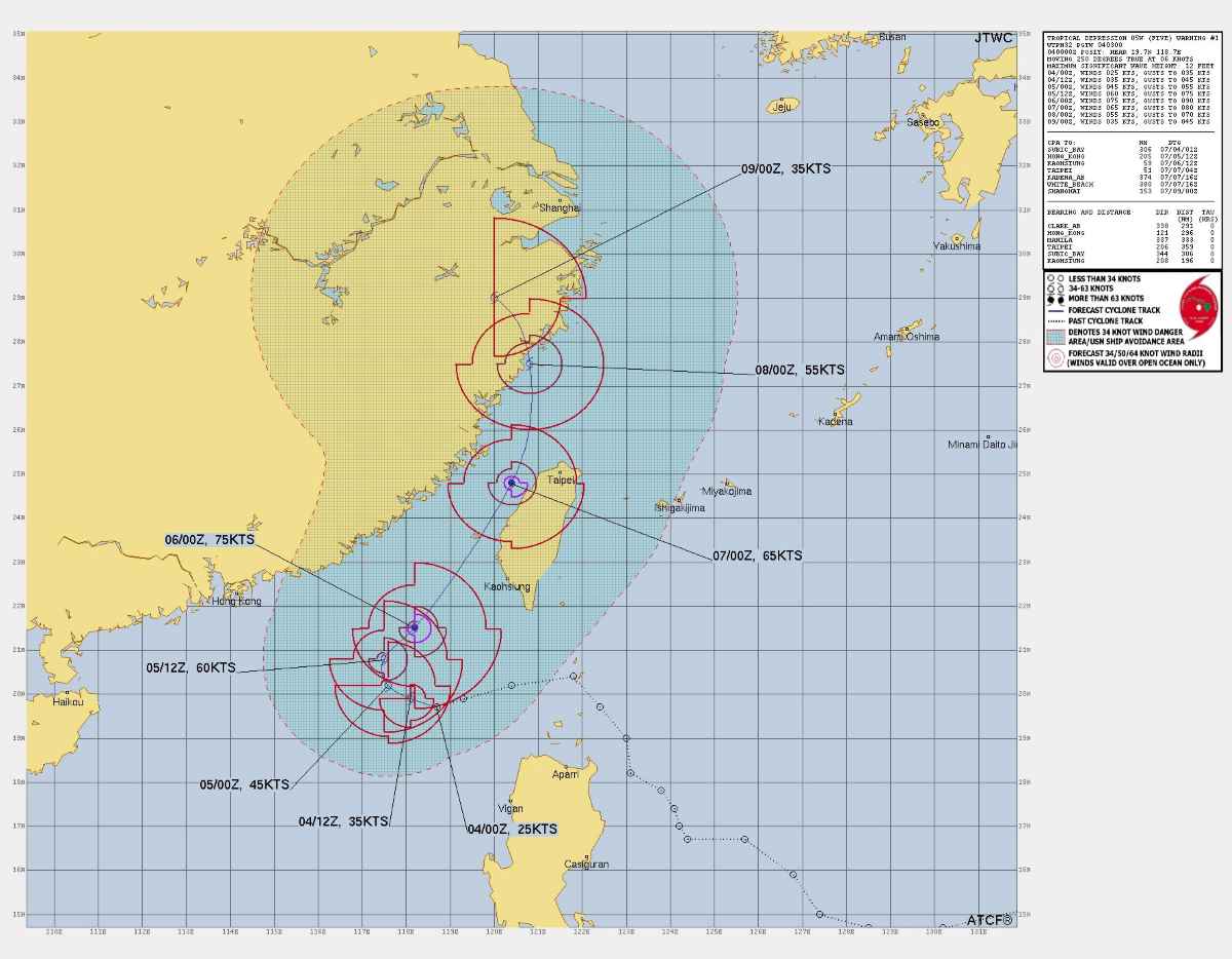
Typhoon forecast models also show that Bising could strengthen into a tropical storm on July 5, as it moves across the waters south of Taiwan (China), becoming the second typhoon in the Philippines in the 2025 typhoon season.

Du bao duong di cua Bising. Anh: ATCF/JTWC
Bising's forecast path. Photo: ATCF/JTWC

The outer circulation of Bising combined with the southwest monsoon is causing a clear impact in some areas of Northern and Western Luzon. The affected provinces are recording strong winds, scattered rain and high waves, especially in places with windy terrain.

Heavy rain forecast for many periods from the morning of July 4 to 5, rainfall in Ilocos Norte is forecast to reach 100-200 mm (heavy to very heavy rain). In Batanes, Cagayan and Apayao, rain will range from 50-100 mm.

PAGASA noted that prolonged rain over the past few days has caused water retention, increasing the risk of landslides and flooding in low-lying areas. Mr. Chris Perez, Deputy Director of the PAGASA Meteorological Services Agency, advised people to closely monitor the weather situation in the coming days.

In the next 24 hours, rough to very rough seas will continue along the coastal areas west of Babuyan and Ilocos Norte, with waves up to 3m high. The seas off La Union, Pangasinan and Batanes will have moderate waves.

According to updated typhoon bulletins, Bising is likely to continue moving off the western coast of Northern Luzon and will completely exit PAR by July 7, but the risk of returning is still being closely monitored.

At 2:00 a.m. on July 4, the weather forecast bulletin of the Vietnam National Center for Hydro-Meteorological Forecasting said that the tropical depression in the East Sea had an intensity of level 7, gusting to level 9, moving slowly to the west.

Tin ap thap nhiet doi tren Bien Dong. Anh: Trung tam Du bao Khi tuong Thuy van Quoc gia Viet Nam
Tropical depression news in the East Sea. Photo: Vietnam National Center for Hydro-Meteorological Forecasting

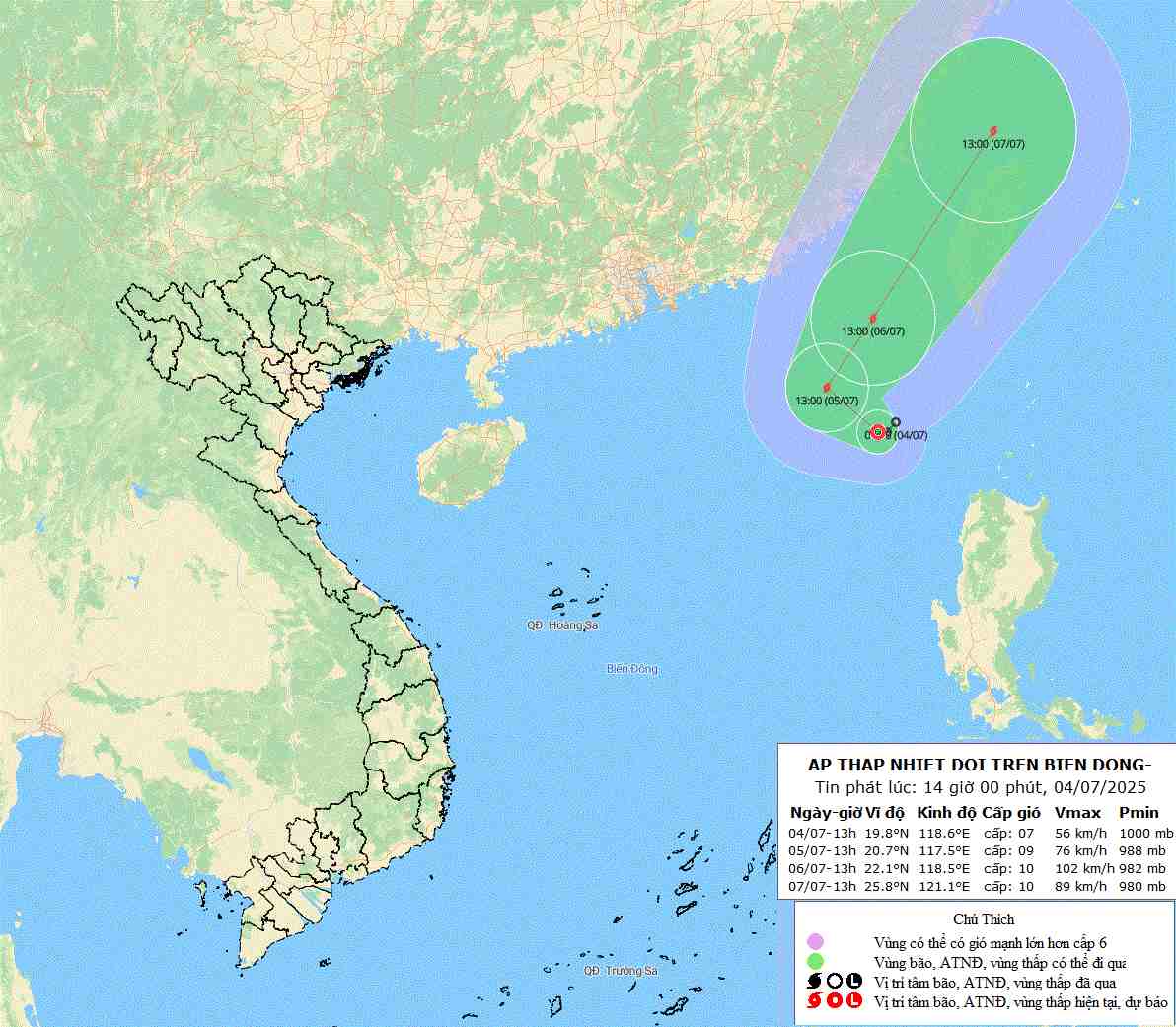
It is forecasted that by 1:00 p.m. on July 5, the center of the low pressure will be at 20.7 degrees north latitude, 117.5 degrees east longitude, in the northeastern sea of the East Sea.

Due to the impact of the tropical depression, the northeastern sea area of the North East Sea will have thunderstorms, strong winds of level 6-7, then increase to level 8-9, gusting to level 11. The sea is very rough, with waves 3-5m high.

Khánh Minh
TIN LIÊN QUAN

Low pressure strengthens into storm No. 2 Bising, strong wind radius up to 200km

|

Typhoon No. 2 Bising has just formed on the morning of July 3 in the Philippine Sea after strengthening from the low pressure.

Storm Bising forecast to form near the East Sea, warning of prolonged heavy rain

|

The low pressure in the Philippines is gradually strengthening and if it strengthens into a storm, it will be named storm Bising.

Low pressure, storms and heavy rain follow each other until the weekend

|

The 2025 typhoon season is heating up with three major storms simultaneously recording strong activity of low pressure, storms and heavy rain.

Benchmark scores for grade 10 admission to 4 specialized schools in Hanoi in 2025

|

The benchmark score for grade 10 of 4 high schools for the 2025-2026 school year has been announced by the Hanoi Department of Education and Training.

Ms. Paetongtarn begins her first day of work in her new position

|

On July 4, Ms. Paetongtarn Shinawatra began her first working day as Minister of Culture after being suspended from the position of Prime Minister of Thailand.

List and codes of 34 provinces and cities, 3,321 new commune-level administrative units

|

The decision stipulates the list and codes of Vietnamese administrative units including 34 provinces and cities used uniformly nationwide from July 1, 2025.

AFC denies Malaysia's investigation into naturalized players

|

The Asian Football Confederation (AFC) has dispelled all speculation about the investigation of Malaysian football, related to the use of naturalized players.

The event expected to have 200 world billionaires in Quang Ninh continues to be postponed

|

Quang Ninh - After a few adjustments and expected in June 2025, up to now, the international event expected to have about 200 billionaires attending continues to be postponed.

Low pressure strengthens into storm No. 2 Bising, strong wind radius up to 200km

Song Minh |

Typhoon No. 2 Bising has just formed on the morning of July 3 in the Philippine Sea after strengthening from the low pressure.

Storm Bising forecast to form near the East Sea, warning of prolonged heavy rain

Ngọc Vân |

The low pressure in the Philippines is gradually strengthening and if it strengthens into a storm, it will be named storm Bising.

Low pressure, storms and heavy rain follow each other until the weekend

Song Minh |

The 2025 typhoon season is heating up with three major storms simultaneously recording strong activity of low pressure, storms and heavy rain.