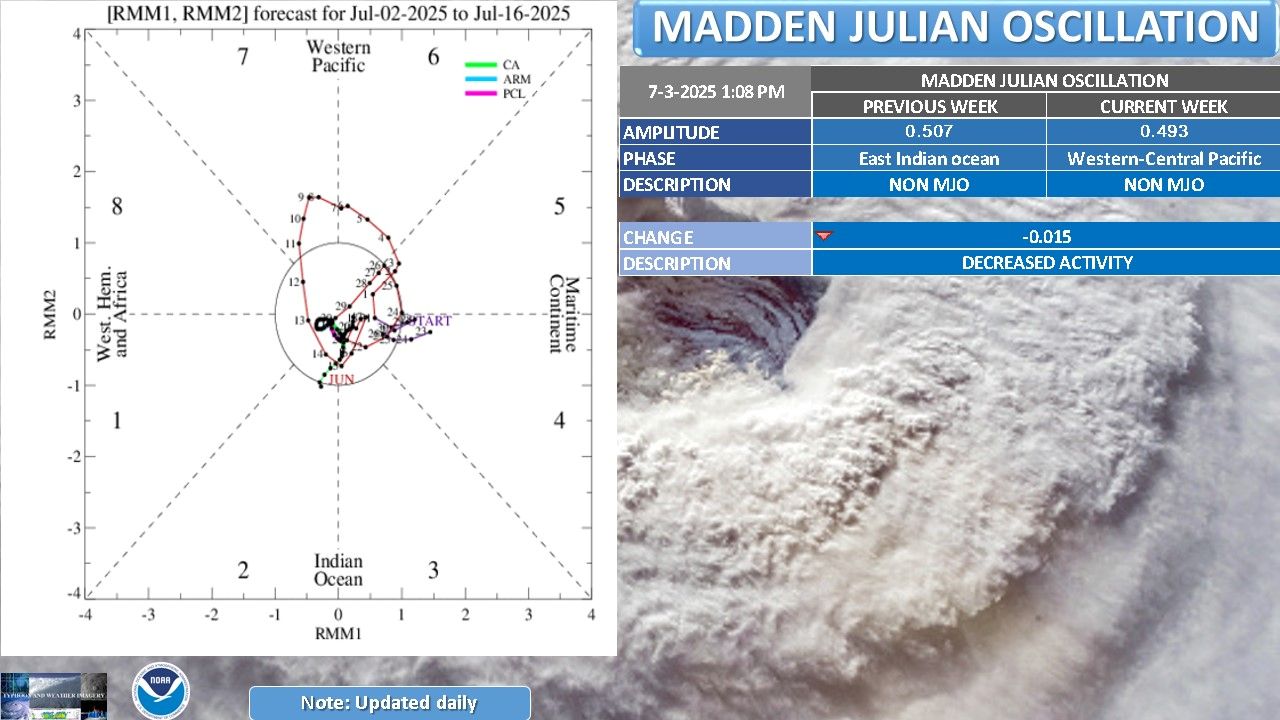
In the last weeks of June and early July, the Madden-Julian fluctuations (MJO) - a large-scale atmospheric phenomenon that often dominates tropical storms - are in a weak and unorganized state.
There is no clear sign that MJO will resume operations within the next two weeks, according to international meteorological centers. Instead, Kelvin and Rossby equatorial waves are becoming the main force, changing the weather landscape of the entire tropical region.
The MJO is a convective fluctuation of the atmosphere moving from the Indian Ocean to the Pacific Ocean, which is likely to promote or inhibit the formation of tropical cyclones. When MJO is active, areas can experience heavy rain, rapid storm formation and accumulation. However, this phenomenon is weakening, showing no signs of spreading eastward - a typical sign of a complete MJO cycle.
Instead, from mid-June, Kelvin - the type of atmospheric wave that spreads rapidly to the east - is dominating. Climate forecast models such as GEFS and ECMWF record active intervention by Kelvin and Rossby waves, creating an unusually high-altitude westerly wind zone extending from the east of the Day Line to the Central Pacific region.
These fluctuations are believed to contribute to activating strong convection and increasing the likelihood of tropical cyclone formation in the Northwest Pacific.
In contrast, in the Atlantic and East Pacific regions, the widespread environment tends to be unfavorable for hurricane formation, at least in the coming weeks. The low-pressure west winds over the Indian Ocean, which used to be strong, are also weakening, reducing the ability to organize convection in this area.
The latest report from the US National Oceanic and Atmospheric Administration (NOAA) said that sea surface temperatures in El Nino regions remained neutral, despite a slight increase in recent weeks. Most climate models predict a neutral ENSO state through this fall, but the chance of La Nina forming in the 2025-2026 winter remains at about 41%.
While MJO has not shown any clear signs of returning, a low- frequency convective bag is forming and gradually stabilizing around Southeast Asia, the Northwest Pacific and the Micronesia archipelago.
Climate centers warn of a possible spike in heavy rains, thunderstorms and storms forming in the area in the second half of July. The slow early season signals in the Northwest Pacific may be replaced by a vibrant phase, when the atmospheric environment converges to prepare for a tropical storm outbreak.
While the Atlantic region and much of the tropics enter a cooling period, the Northwest Pacific could become a water center in July, as Kelvin and Rossby waves rise strongly, paving the way for dangerous storm and super typhoon systems to form.


